Monday, 30 May 2016

In Praise of Limestone.


Saturday 28th May 2016

Circa 1960 (my age, about 19); I am dozing on a hot sunny afternoon on a bank of the Upper Wharfe after several lunchtime pints in the Buck Inn at Buckden. Ian and Tony are similarly arrayed. We have spent the morning trout fishing, but intentions of continuing on the river have been drowned after our sojourn in the pub. Out of the corner of my eye I see an elderly farmer type who has approached and stopped to survey the scene. Despite the sunshine he wears a greasy, work-used three piece tweed suit, and a flat cap moulded to his head, and he has a bucket over his arm; he sums up to himself, "Ee! It must be t' frseh air 'as dun it".

Well today I parked up at Buckden on a thirty-car sized car park that didn't exist in 1960 and paid £4.50 for the privelege. My mission was to walk a previously un-walked section of  the Dalesway. To make this more worthwhile I climbed up onto the high ridge on the western side of the dale and followed, mostly on faint but decent paths, passing  Birks Tarn teeming with gulls and other water birds, to the trig point at Horse Head and beyond. There was a great top-of-the-world feeling up there. I descended to Beckermonds and connected to the Dalesway following the Upper Wharfe downstream, through sheer delight back to Buckden.

I saw nobody until I was on the Dalesway path then casual walkers were abundant, and cars parked on the road across the river  with families picnicking and playing in the tempting pools of the Upper Wharfe. Strangely the dale is called Langstrothdale. Back in Buckden the place was busy with many walkers and visitors and the car park which was empty at 9:00 am was full. I called into the tearooms (back in the 60s there was just a village shop). The proprietor has been in the village for many years and we reminisced about the characters we had both known. Jacky Beresford was a local always found in the Buck Inn;  we used to buy him a pint and get him going with stories of giant trout caught in the river. Jacky operated a school-run business using an old hearse. Then there was Major Horner, notorious, bad tempered landlord of the White Lion at Cray, a mile or so up the road. He once attacked some customers who had caused him some annoyance with a claw hammer. I have tried to research that story which was well publicised at the time, but with no result, but I did find this extract from a nostalgia article in the Craven Herald:

The White Lion was also in the news as its landlord and eight local farm workers were caught drinking when police walked in at 11.30pm. With licensing hours a hot topic today, it is interesting to note that in 1955 last orders was at 10pm with the premises to be vacated 10 minutes later. Major Horner, the landlord, was fined £3 and three of the drinkers fined £1.

I drove home passing through Kettlewell, the departure point for the walk up to the Scout Association owned farmhouse, Hag Dyke just below the summit of Great Wherneside which we visited many times back in the mid 50s - the scoutmaster left us to our own devices exploring potholes and caves with candles and torches - good for him; these days he would probably have been sent to jail - oh dear!

I drove back up Littondale where we also used to fish for trout in the Skirfare. We got to know the Ingleby family who had the big house beyond Litton and they gave us permission to fish. In contrast to Langstrothdale, Littondale was quiet and largely unaltered - it is high on my list of favourite places ever visited.

I like to think of myself as a forward thinking person, but old memories are priceless and a little wallow is not a bad thing now and then.

                                                ----------------------------------------


If it form the one landscape that we, the inconstant ones, 
Are consistently homesick for, this is chiefly 
Because it dissolves in water. Mark these rounded slopes 
With their surface fragrance of thyme and, beneath, 
A secret system of caves and conduits; hear the springs 
That spurt out everywhere with a chuckle,   ...

W.H. Auden 


Buckden from high up on Kirk Gill Moor

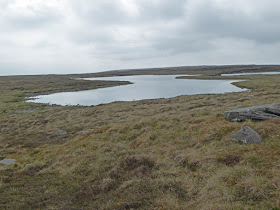
Birks Tarn - it was teeming with bird life (not apparent in the photo)

I think I've got the hang of macro with the TZ60 now


The maps says "area of shakeholes", unfortunately a repository for rusty old fence wire and posts

Descending to Beckermonds. The Dalesway follows the river just beyond the central barn

The delightful infant Wharfe

Clockwise from Buckden - 13 miles - average speed including 20 min stop for munchies and coffee - 2.08mph

Thursday, 26 May 2016

Wray

Thursday 26th May 2015

Thursday walks with Pete continue, but in consideration of Pete's arthritis, we keep within four miles, and preferably avoiding much hill climbing, and wherever possible on surfaced road. With those parameters finding new walks within a reasonable driving distance is becoming increasingly difficult, especially when I add a personal preference for circular rather than linear routes. We have been doing these walks for several years now and have hardly ever repeated a previous route, and rarely experienced rain. 

Pete has no objection to that quirk of mine, pointing out that the view on the return is different, and that companionship and enjoyment of the outdoors in general is more important, and I know he is right.

So, from my standpoint, this opens up a new range of walks. There are many roads in our area that end in the middle of nowhere, and I can just plot back two miles from the end to an undistinguished spot back along the road to create an exact four mile round trip, and so it was today.

I feel liberated.

We had extensive views of the northern edge of the Bowland hills on the outward journey and across to the Three Peaks area of the Yorkshire Dales to the east, and out to the Lancashire coast to the west on our return. All this was enhanced by a mini Farnborough air display as an RAF jet made countless circuits just within sight of the whole of our domain, banking, climbing and making spectacular low level passes. 


Another relic

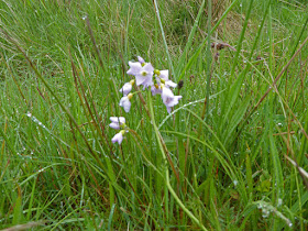
Identification please. Pete says Milkmaid, but I can't track it down in my flower book.
I really must master the macro function on this camera - this photo is pathetic.

Start/finish SD 612 662
North south, south north.
Ignore the cursor stats top left

Tuesday, 24 May 2016

I do a Nick Crane

Anybody who walked for seventeen months non-stop across Europe from Cape Finistere to Istanbul, following the high ground, through all the seasons of the year, has my admiration. What's more is that Nick Crane  also writes well, and Clear Waters Rising is a classic.

My first acquaintance with Nick was on tv years ago when he did walks programmes, and I thought he was a bit of a fraud, with the posing umbrella, and possibly only doing a short part of the walk with the helicopter in the background ready to whisk him off to a luxury hotel. I then  read Clear Waters Rising and found out more about the mass of epic cycle rides and impressive outdoor activities he achieved as a boy and young man encouraged by an enthusiastic father. Well, Nick is entitled to as many helicopters as he wants with that pedigree - he writes about his father and his eccentricities in amusing anecdotes in his Two Degrees West, another minor classic. All that brings me to a particular eccentricity of Nick's that I have observed on his tv programmes when he frequently wades, unhesitatingly across rivers and just carries on walking with sodden boots and socks.

Today I wanted to walk another part of the Dalesway I have not covered before, and not long after the start I would cross the river Lune by Fisherman's Bridge (SD 628 944) to pick up the Dalesway on the other side. Leaving the road at SD 625 943 I was informed by a Yorkshire Dales National Park notice that the route was impassable a few hundred yards down the field where the footbridge  had been washed away by floods. I decided to investigate.

Ambitious to achieve my goal I surveyed the river and thought of Nick and a rude saying I can't include here: faint heart never...

In I launched and waded the knee-deep twenty yard crossing, and in stoic style continued the rest of my walk without bothering to stop and wring out socks etc.

This section of the Dalesway supported my opinion that it is one of the best country walks in England, a view I have substantiated on a previous post on this blog - I have done perhaps half of it in bits and pieces and in a way spoilt the possible enjoyment of doing it as a continuous walk, but I intend to fill in the other gaps on circular day walks whenever the opportunity arises.

PLEASE CLICK PHOTOS TO ENLARGE

Down into the Lune valley - Howgills beyond. How did those eccentrically shaped fields evolve?

Pleasant walking on the way down to the Lune

Looking back at my river wading point


The Lune Viaduct on the now disused railway. The Dalesway goes underneath

Lincoln's Inn Bridge with reflections

Upstream from Killington New Bridge

A welcome lunch spot, or so I thought. The ground was eroded and my feet were dangling with circulation in my legs restricted - 'twas a bit uncomfortable, but this was not on the Dalesway so no marks lost

Clockwise. The river crossing is at the furthest point north

Sunday, 22 May 2016

Cheriton Hill and Wendover Woods, Marilyns


I had only four English Marilyns left to do:  Cheriton Hill near Folkestone and Wendover Woods in an inaccessible, for me, corner of Buckinghamshire, and Kinder Scout and Mickle Fell. The first two of these were disproportionately far away from home to justify the cost, effort, and time needed to tick them off, but then I was blackmailed by Gimmer who comments, here, and is a lifelong friend. We have shared many climbing, caving and walking adventures over the years in the Yorkshire Dales, The Lakes and Scotland.

Gimmer needed help on a job in Chamonix over an eleven day period and promised to let me tick off the two problem Ms on our return car journey if I agreed to accompany him.

So yesterday, after having driven over 500 miles from Chamonix to Dunquerque on Friday, and risen at 4:20am to catch the six 'o clock boat we found ourselves parking in a field at around 9:30 am a few hundred yards from the "summit" of Cheriton Hill. You wouldn't know it is a summit being just a few inches higher mound at the corner of a flat field. However Cheriton Hill did offer  bonuses. I have often ranted about the ubiquitous orange hairy string used by farmers which is impossible to untie once knotted, and more recently with Pete we came across a pink version. But here we found a stile largely constructed from this wretched stuff tied to form a squared grid fencing, but would you believe it in YELLOW! Is this cheapo stuff made in regional colours?

Whilst taking photos of our triumphant conquest a couple of horses arrived and became quite friendly - I'm none too confident with horses  but the white one seemed particularly friendly,

We also found a dilapidated Nissen hut, a remnant of WW2 which made a welcome addition to my "relics" collection. This area was of course the front line of defence, and local roads have wartime names, and there is also a Battle of Britain museum nearby.

So you never know what you might find when you go off list ticking however insignificant the hill may be.

More driving took us to Wendover Woods where you can access this Forestry Commission park by car to within a few hundred yards of flat walking to gain this Marilyn and "the highest point in the Chilterns" - there is even a signpost pointing the way and an arrangement of large stones with a plaque when you get there.

Thanks to Gimmer for making these two of the last four much easier. I hope to mop up Kinder Scout within the next week or so, and Gimmer lives nearly next door to Mickle Fell and we will arrange to do this together after getting permission from the military which will provide a fitting conclusion.

Ingenious use of hairy yellow string (looks a bit green in photo but 'twas yellow for real)

Triumphant at the summit. I'm even wearing my smart brown shoes

Not sure what Gimmer was doing here. It was mighty cold for late May


Nissen hut

Wendover Woods. The highest point in the Chilterns


Monday, 9 May 2016

Bannisdale Horseshoe (Outlying Fells)

Brother RR who comments here has often suggested that we outdoories should include a wider ranging content in our accounts of walks, rather than boring descriptions of the route, and in particular thoughts that pass through our minds.

Well when one walks with BC there is not much opportunity for personal thoughts because non-stop conversation is the order of the day. BUT, today we had not been long on our walk before BC asked me if I knew what Boatey McBoatey was all about (if you don't know Google). I explained what I knew, but I was not sure if there was more meaning to that name than I was aware of, and made a mental note to Google when back home. That resulted in the name flying round in my head for the rest of the walk like a crazy drone. Back home I did Google, and as far as I can tell it is just a silly name that the perpetrator invented.

The Bannisdale Horseshoe is a long wilderness walk with much more accumulated ascent than a casual look at the map conveys -  2500ft plus and nine Wainwright summits with a few others he doesn't include in his list. At last we have some warm, shorts-wearing, weather which although welcome tends to take its toll.

This was the grand finale for our "winter" campaign to conquer all 116 Wainwright's Outlying Fells. From our first summit, Whiteside Pike, we had a grand view up Bannisdale, but not round the last corner to the lonely farm at Bannisdale Head. Across the valley was Capplefell Crag which caught BC's eye, as did Mere Crag across the way from the head of Bannisdale later on - once a climber always a climber. I am sure he is in collusion with Cicerone Press producing a new issue: "Wainwright's Outytling CRAGS."

So, with much regret that is the end of our little project which I reckon has been more worthwhile than I could have imagined.

                                            **************************

Tomorrow I am off to Chamonix with commenter Gimmer to help with a contract job he is doing there. I don't think we'll get a chance to summit Mt. blanc.

Across Bannisdale to Capplefell Crag

Down into Long Sleddale

Minimum effort put into creating this fence crossing - you still had to climb over the lower strand of barbed wire

Skeggles Tarn

Mere Crag

Route clockwise. Start/finish on road at foot of Bannisdale. The other leg to the south is Wainwright's suggestion which adds a couple of miles and more ascent

Thursday, 5 May 2016

Halton, Lancs.

Another Thursday walk with Pete. For some who may be concerned, in a recent post I referred to "my late friend Pete" -  that was not Pete of Thursday walks fame ! It was another friend who I climbed with for a number of years from 1991 who sadly is no longer with us.

At last we have some warm weather and I walked in shorts for the first time this year - what pleasure that was.

The new Panasonic TZ60 is performing well. Although the sensor is supposed to be the same as the old TZ40 I am finding that I am making many fewer adjustment to lighting etc, in Photoshop.

Here are a few photos.

PLEASE CLICK TO ENLARGE

This building bore the plaque shown below

I Googled a translation which left me none the wiser:

"So as to benefit, not for themselves, but for all the President of the..."

The date is 1978 


Zoom to Ashton Memeorial, Lancaster, 4 miles away

If you want an example to define ubiquity here it is (Lucozade in particular)


Clougha Pike and Grit Fell, northern Bowland hills


River Lune

Start/finish at Halton, clockwise