Monday, 28 November 2016

Wyre Way in sections (5)


Sunday 27th November '16

It's a struggle getting up early on these cold, dark mornings, but it means I can be back home by mid afternoon to enjoy a hot bath, a good meal, and an evening of lowbrow entertainment on the tele.
The Wyre Way seems to become less inspiring as I squelch across muddy fields, and further on stumble over plastic bottles, driftwood and other detritus as the river becomes tidal.

Squelchy fields...

...and more squelchy fields (different colour this time)

We've got a funny chimmney

Back to the Wyre, now tidal - I was puzzled because it was flowing the wrong way - tide coming in

Jungle - many plastic bottles underfoot

And more squelch - if you really want to enhance your experience, click to enlarge

Shard Bridge.
 The walk will eventually finish at the lefthand end after continuing up this right bank to Knott End and crossing on the ferry to come back down the other side

Massive pylons take electricity across the Wyre


From Wikipedia:
Out Rawcliffe is a village and civil parish on the north bank of the River Wyre in the Over Wyre area of the Fylde in Lancashire, England... 
... The village has one Anglican church, Out Rawcliffe St John Church, built in 1838 in the Romanesque style by John Deerhurst, the year after he had designed Preston Prison.

I think he must have been suffering from depression after the prison experience - this is one of the ugliest buildings I have seen for a while - (Grade 2 listed)

Click to enlarge - I walked anticlockwise on the Wyre Way (green) from Ratten Row to Hambleton and back on the blue route. The eventual finish and proposed return can be seen arriving at the other side of Shard Bridge

Friday, 25 November 2016

Wyre Way in sections (4), and Thursday "walk" with Pete

Wednesday 23rd November

Just for the record:  a pleasant but muddy walk starting from my last finishing point in Garstang and finishing at Great Eccleston - I caught the bus back to Garstang from there.
                                            🚌🚌🚌🚌🚌🚌🚌🚌🚌🚌

Approaching Lancaster Canal aqueduct from Garstang. The canal is carried over the River Wyre here.


What a superb construction that has lasted for over 200 years, and carrying water at that - unbelievable!
My route went across the aqueduct and up the canal for a hundred yards or so before branching off to follow the river again on the opposite bank


Right of way blocked. There is a huge housing development underway here on the outskirts of Garstang. 
I managed to squeeze through the metal fencing to the left and...

...continued to walk awkwardly - the way was slippery and muddy and obstructed by trees further along

St Michael's church

Toll bridge back over the Wyre to Great Eccleston and my finish - free for pedestrians

🚗🚗🚗🚗🚗🚗🚗🚗🚗🚗🚗

Thursday 24th November
Sometimes the course of a day can be predicable. Not so this Thursday.


Daughter Jill had phoned me last night to say her car had croaked and could she have a lift to school at Barrow so I was off at 7:00 am.

On the way back the warning lights came on Yeti again after I had only picked it up on Tuesday having payed the £780 bill - oh dear! Well, my actual unspoken language was a bit stronger than that.

I phoned Skoda at Morecambe and drove there with my Thursday walking day with Pete now under threat - It was 9:00 am - I usually pick Pete up about 10:30. I was given a horrid little Skoda Citigo courtesy car, but at least I was mobile and drove back to Arnside for Pete. We set off driving to walk on Scout Scar south of Kendal, but on the way my mobile chirped and  Skoda informed me that they had only needed to re-set the warning light system and Yeti was ready again so we turned and drove back to Morecambe.

By now I was beginning to feel disenchanted with Skoda after my ten year relationship with them, and also after reading prophets of doom here on comments on my last post. A few hundred yards from Skoda we passed Rayrigg Motors and I said jokingly to Pete, "we'll call in there on the way back and waste time with one of the salesmen."

There was no way in the world that I thought I could afford to change the Yeti for a new car, but I had been wrestling with the dissatisfaction of having a car that was out of guarantee with the potential for further costly repairs. I was shown a Kia Soul Connect 1.6 petrol demonstrator that had only done 2300 miles reduced from an original retail cost of £16,000 to £11,995.

After several enjoyable rounds of haggling with the salesman going back and forth to his boss I  reduced his original offer to change by £1000 and including £400 worth of towbar to be fitted and six months road tax. That was a bit under the maximum amount I had in mind for changing the Yeti so I signed up.

OK, it is not 4 x 4 or automatic as I would have liked, BUT it has a seven year warranty and a good service plan and is well appointed - in particular, a rear view camera in lieu of reversing sensors and cruise control, and Bluetooth hands free mobile phone facility with voice command, and above all provision of peace of mind for a number of years.

🚗🚗🚗🚗🚗🚗🚗🚗🚗🚗🚗🚗🚗🚗🚗 (mine is white not red)


Monday, 21 November 2016

Wyre Way in sections (3)

Sunday 20th November '16

I have titled this number 3 although the last actual walk was titled number 1.  Back in January 2013, I walked the first part with Gimmer - see post here CLICK, so today's effort is actually the third section walked.

After several days of bad weather and being messed about with the repair to Yeti expecting it to be ready on a daily basis from last Saturday I was suffering acute cabin fever on Sunday, so I was off and away. I am still waiting to hear about Yeti as I write this on Monday morning; I dread to think what the cost of the EGR valve replacement is going to come to - it seems they have to dismantle many parts of the engine to get to it.

I have a basic 1.6 diesel Skoda Rapid courtesy car, and I have to say it is quite impressive with acceleration better than Yeti, and with truly sporty direct steering - I am back in boy-racer mode.

Weather forecasts have been remarkably accurate for more than a year now, but today rain forecast from 2:00pm onwards never arrived and I had blue sky and sunshine all the way, but the predominant ingredient was mud featuring squelchy paths through woods and waterlogged fields, but I am proud to say that my feet were still dry at the end even though I was only wearing trail shoes.

Click to enlarge - Wyre Way from north to south in green first, and return  route in purple. The Wyre Way in green continues north and south before and after my start and finish today

The Wyre looking north from Street Bridge at the start of this walk

These two were threatening each other energetically without actually coming to blows, the guy in the background was moving int to see what all the fuss was about - better than watching tele?

I was off route here - this dump, come scrapyard, come gravel extraction site was about four times bigger than the area seen here. I managed to avoid the barking dogs and eventually found the hidden footpath sign and stile leading into an adjacent feild

One of two M6 crossings. You will see from the map that I was never far away from the motorway and I could hear the roar throughout the whole of the walk

From the M6 bridge with snow covered Bowland Hills.
At about 70m above sea level this was probably as far as I got in terms of "going high"


Out of Scorton.
 The WW folows this road for a couple of kilometres, but just by the distant tree a raised footpath on banking above the river has been constructed as a Milennium project making for pleasant walking despite the road.

Zoom - Nicky Nook - a popular walk ascends this little fell from Scorton - we did it many times when living in Preston - great views

Water pipe bridge (1927) over the Wyre near Garstang -  carries water from Barnacre Reservoir to Blackpool - there is a similar one crossing the Lancaster canal a kilometre or so to the west. The unique architecture seems to be out of place in these surroundings

What can you say?

Grizedale Fell

Monday, 14 November 2016

Planet Earth 2

Last Night I watched David Attenborough's Planet Earth 2.

It is beyond comprehension that they can keep on improving on previous triumphs introduced by DA, but they do just get better and better, BUT...

...last night there was deafening intrusion of orchestral music so loud I had to turn the sound down.

One of the best sequences in the whole film was watching the grizzly bears scratching their backs on the trees. If we had been able to hear properly they were creating their own fascinating ecstatic growling soundtrack, but this was drowned out by cacophonous bongo drums almost demanding the use of ear defenders.

One of the best programmes ever was practically ruined for me as I remained on edge throughout as I kept wincing as yet more inappropriate background, nay foreground music drowned out the sounds of nature.

Many other people complain, but the programme makers seem to be in denial - what are they thinking about?

Sunday, 13 November 2016

NOT Wyre Way in sections (2)

Sunday morning and I am breakfasting as usual, but having some difficulty in pouring tea from the teapot, and looking out of the window at a courtesy car loaned by my Skoda dealership.

Saturday was not good.

Full of noble intentions despite a dodgy forecast I set off early to walk what would have been the title here but without the first word.

Yeti, occasionally gives me palpitations by displaying one of its many warning lights, but usually that has been some triviality: coolant level low, or a blown bulb etc.

In buoyant mood, cruising the M6 south of Lancaster,  with coffee flask and nibbles stowed in the rucksack, I was in good time and looking forward to my twelve mile circular walk. Then the orange light that looks like a coil of wire started flashing. That light normally comes on, without flashing, at startup indicating warming up of the glow plugs, then disappears when that job is completed.

Power dropped off; we had gone into what the manual joyfully calls "limp mode". I motored on to the south Lancaster exit and looked at the manual - by now there was another warning light: a pictogram of a car engine. Pessimistically,  "perhaps I am going to need a new engine?"

Pessimistically again, "I bet the service department of my Skoda dealers in Morecambe isn't open on Saturday morning."  It was 9.15. I phoned. Without hesitation, "bring it in as soon as you can."  Twenty minutes later I was fantasising over a top of the range, four wheel drive Skoda Octavia Estate Car in the showroom whilst drinking a cup of 9.5 out of 10 coffee. "This is going to cost." 

They have an attractive and knowledgeable young lady who fronts up the service department, a masterstroke designed to take the sting out of bad news about expensive replacement parts. A valve in the exhaust system had broken. That was explained in some detail that I can't now remember, but it seems that this part is susceptible to carbon build up leading to its failure (Skoda owners beware!) Replacement cost will be circa £200 plus fitting. They will have the part on Monday or Tuesday. Without further formalities, not even a signature, I was given a Skoda Rapide courtesy car to drive home in - I know all this is going to cost, but such good service from the dealership is priceless.

Things were looking up.

By now it was too late to return to my walk. I decided on a shorter foray nearer home after a bit of shopping at Aldi, Carnforth. Rain had continued beyond the forecast.

At Aldi I marched off from parking to the store still wearing my Crocs -  I prefer them for driving - they allow me to go into cruise control and remove my right foot from the accelerator to stretch my leg and ease my dodgy knee.

The entrance to Aldi is paved with polished ceramic tiles, now wet with the rain. Within a nano-second I was horizontal in the air, then painfully on my back. Much as I wanted to sort myself out I was immediately surrounded by well meaning helpers including an off duty nurse who was taking my pulse. They bundled me into the store, summoned the first-aider who brought a chair. I then saw she had her mobile to hand and it took forcible, and unintentionally ungrateful words from me to stop her calling an ambulance.

My brow was dripping with sweat and I did feel groggy. I had taken the major impact on the upper part of my back with a secondary knock to the back of my head and I had also badly sprained my right thumb and a finger on my left hand.

Eventually I recovered enough to do my shop and drive home.

Thankfully parking on my drive, and looking forward to recumbent recuperation, I realised that in transferring my belongings from Yeti to Rapide I had left my house keys behind. Thankfully daughter Jill has spares and lives in Arnside and the day was saved.

The sprained digits are proving troublesome - last night I had to use some ingenuity to get the cork out of a bottle, but needs must...

This morning I feel fine, but perhaps fortuitously the forecast is bad enough to stop me from charging off again - another day's rest is perhaps a good thing.

Monday, 7 November 2016

Wyre Way in sections (1)


SUNDAY 6th November '16

The Wyre Way is a strange long distance path (LDP), I say long distance but it is only 45 miles. It  starts at Abbeystead and makes a loop north then east following the Tarnbrook River Wyre into the attractive footings of the Bowland Hills then swings south and west to follow the Marshaw River Wyre without going to the source of either of these two feeders, then  returning to Abbeystead where the two rivers join to form the river Wyre proper.

The main river is then followed to its mouth at Knott End-on-Sea where logic would say it had achieved its objective, but no! The ferry is taken across the mouth to Fleetwood from where the walk follows the western coastline before cutting across the peninsula to finish back at the Shard Bridge over the Wyre. There seems to be no rationale for this final section or the finishing point, but there it is. The route is well way-marked, and I think well used.

Click to enlarge - The blue line shows my return path today - see below map for more detail
In January 2013 I walked the first loop from Abbeystead and back with Gimmer.

CLICK HERE TO SEE POST

Today I decided to carry on and walk the rest in sections using other paths to return to my starting point each time, which will take a few visits - I can only walk half the distance on the LDP from my total distance for each walk.

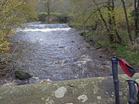
Please click to enlarge. This man-made beauty seemed to rival nature at its best - the whole ambience of the shimmering, flowing water and the sensuous curves moved me quite profoundly

A bit further downstream this elaborately designed bridge must have been associated with the waterworks of the weir - I'm not sure of the date but it comes from an age when design was considered well beyond utility - see next photo

Again, please click to enlarge. Note the round top rail with the contrasting square bottom rail and the elborately designed joining brackets and the elegantly tapered pillars

Back towards the weir - not much sunlight, but autumn colours and light still forceful

I quote below from the above mentioned post recording my earlier visit.
The commemorative stone with the plaque (photo below) is seen bottom left
"Abbeystead, starting point for this walk, was the scene of a dreadful explosion in an underground building at the waterworks in 1984 that killed 16 of a visiting party of 44.

Although I lived only a few miles away in Preston I have always had a feeling that I would somehow be intruding if I visited - the same applies to Lockerbie."


A more modern bridge than the iron beauty - utility rules

Dolphinholme
More attention to attractive stone built architecture in this backwater village
Start Abbeystead - clockwise

This waymarker was not on the Wyre Way, just a minor public footpath on my return route, and I saw no others to supplement it. Anybody any knowledge of its references? Note the letters "TA" on the top surface. As far as I can remeber it was located at approximately SD 554 533


Saturday, 5 November 2016

A bit of tidying up

What a good little outing arising from a prick of conscience. I have many times visited Hutton Roof which name describes a large plateau of limestone six or seven kilometres square with the village of the same name nestling beneath. There is a line of small crags which provide excellent one pitch climbs on a summer's evening which I frequented some years ago in my climbing days, and I have ranged all over tracking down Geoacaches. There is also a trig point which I visited when I was embarked on my trig campaign for that OS sheet, consequently I had, more recently, ticked it off as a qualifying Marilyn.

Recent conversation with Mick and Gayle informed me that the true summit is 110 metres from the trig bearing 64 degrees and 0.6m higher! I might well have trampled over that point at some time but couldn't be sure, and today was blue sky and the best of autumn so I had a double motive for the walk.

I ascended from the quarry car park at SD 552 761. On the summit I met a couple with a border terrier. It turned out they had bought the dog from people who breed them living only a few hundred yards from me in Arnside. Those people were also the same who gave me a lift back from Longsleddale  when I lost my car keys bum-sliding down the fell-side in October 2012 - one of my more self deprecating anecdotes  CLICK HERE TO READ POST.

Having given this couple a bit of directional advice (they had no map or compass) I paced out the 110metres to the grassy lump posing as the true summit then returned to the trig. All of a sudden there was a sort of whoosh behind me and a collie dog came flying through the air and landed on top of the trig - I am not making this up. The dog was followed by two more collies, all very friendly, but less ambitious to leap onto the trig. Their owner appeared and he turned out to be an enthusiastic walker and  very amenable, and we chatted for quite some time about our walking experiences, and our good fortune to live in such a splendid environment.

I decided to drive back on nerve-racking  narrow country lanes with few passing places and much grass growing in the middle. As I descended to Cawthorpe I had to pull in for a large 4 x 4 coming the other way heading for the worrying narrow lanes I had come from. The lady driver stopped and wound down the window, "we're not from around here, can we get to Lake Windermere up here?" I was just dumbfounded - how could anybody think that they may be remotely heading for our largest lake in England over sixteen miles away (even in a straight line) up this road which is not much more than a surfaced cart track. I often wonder what happens to people like this after my encounter.

Wonderful limestone country walking

A bit of a zoom back to the trig from the supposed highest point

Any walk within a radius of thirty miles from my home gives a good chance of seeing Ingleborough


The bottom red dot shows where I met the 4 x 4 and the top one is on Lake Windermere which is probably twenty miles away by road