For newcomers

At the bottom of each post there is the word "comments". If you click on it you will see comments made by followers, and if you follow the instructions you may also comment and I always welcome that. I have found many people overlook this part of the blog which is often more interesting than the original post!

My blog nick-name is SIR HUGH. I'm not from the aristocracy - my middle name is Hugh which relates to the list of 282 hills in Scotland compiled by Sir Hugh Munro in 1891. I climbed my last one (Sgurr Mor) on 28th June 2009

****************************

Showing posts with label canals. Show all posts

Friday, 17 July 2015

Walks and modern life

Yesterday was my Thursday walk Pete and also this time with Pete Two We  had another addition to the party with grandaughter Katie who is now 3yrs and 10 months.

Well, I could do with a similar soothing walk at the moment. A few days ago I negotiated a Vodafone update. I received the wrong phone and today that should have been picked up and the correct one delivered. Not having received the customary confirmation email I have spent all morning on the phone to Vodafone. I lost count but reckon I spoke to six different people, had three seperate long phone calls, and been on hold for several periods in excess of 20 minutes (actually timed by my phone) listening to the same pop song over and over, and over and over. As far as I understand there has been a mess up - the order has now been re-established and I will, supposedly, receive notification of the new delivery/pick-up time within the next 48 hours.

I can't help but be annoyed and frustrated at this service, but putting it in context with the wretched existence humans have in underdeveloped countries, and countries with catastrophic political upheaval I shouldn't really be complaining, but the way things are going I reckon we should not be complacent about our privileged way of life.

We walked up the Lancaster Canal from Crooklands picking up two geocaches and failing on two others. Geocaching is great for young children. The round trip was just over four miles. Normally I think children get bored rather than tired, the symptoms being similar, but geocaching provides interest and diversion. Katie walked well until the last quarter mile on the return when I lifted her onto my shoulders - that took two attempts. I don't think it will be long before I could not physically lift her like that having to fully extend my arms holding her above my head - how fast they seem to grow.


Sunday, 14 July 2013

Kennet and Avon Canal Walk Slideshow

I have discovered Dropbox: a facility  for sharing files and photos so here is the full slideshow for the Avon Canal Walk.

Click

Then click on first photo to see slideshow

Semington to Bath (last day)


Saturday 13th July


A splendid breakfast was delivered before I retired. Fruit juice, two croissants, fresh strawberries, yoghurt, and an apple and banana, and a cheese sandwich.

The forecast said, "hotter than yesterday". I was away at 5:45 hoping to beat the heat, but by 8:00 it was already uncomfortable.

From Bradford-on-Avon the canal was much busier with holiday boats, and many more cyclists to the point where they became a damned nuisance - the heat tends to make me bad tempered. I was too early for any of the cafés I passed, and eventually got a pint of orange and lemonade at The George about three kilometres from Bath. I have been charged £1.86, £2.36, and, at this last call, £3.20 for that drink.


The canal wends its way through the atttractive Georgian architecture of Bath, and finishes in an indeterminate fashion - there is a descending lock which would put you into the River Avon and onwards to Bristol, but from appearance, at this stage it just looks like a continuation of the canal.

At the final lock it was 12:40 so I had covered the fifteen miles in approximately seven hours. Even with that early start the heat was a killer, and I was soaked in sweat and somewhat bemused almost to the point of hallucination when I arrived, and I'm sorry to say I was in no mood to explore the wonders of Bath. I walked the few hundred yards to the railway station. It was 12:50, and luckily, I was able to board the 13:00 train to Birmingham, the first stage of my homeward journey. From Birmingham to Preston took two hours with no air-conditioning. I was running with sweat the whole journey wearing the same shirt I had worn, except for evenings, for the last five days; I don't know if this was apparent to my fellow passengers, but it was not something that was worrying me.

 From Preston I landed at Arnside for 18:41.

----------------------------------------

I would recommend this walk highly. TheKennet Avon is by far the most attractive canal I have explored, and much less walked than I expected, certainly as far as Bradford-on-Avon. Places of refreshment are scarce without diverting from the canal, so if it is hot I suggest carrying plenty of liquid. I can normally go all day without drinking much, but on this trip the heat was intense and after the first three hours I was craving for liquid for the rest of the day. I wonder what it would be like as a winter walk?

-----------------------------------------

At last I can post some decent photos taken with my camera instead of the woeful results from the iPhone.

The River Avon from the Avon Canal aqueduct at Avoncliff

Quite a lot of this walk was fortunately in dappled shade, but there was plenty in uncomfortably hot sunshine as well

On the way into Bath


The final lock taking the Avon Canal into the River Avon. It is not apparent here but we are in the town centre only about three hundred yards from the large railway station


Sent from my iPhone

Friday, 5 July 2013

Sir Hugh is off on holiday

This time it's unashamed indulgence. For the first time ever I have booked accommodation for all five nights in advance and not a campsite, youth hostel, bunk barn or dosshouse in the itinerary, just four pubs and a bed and breakfast. No need for an EPIRB, and no humping tents, sleeping bag, cooking equipment etc, just a diddy little rucksack with a toothbrush and a decent shirt and clean socks to don when I dine.

The Kennet and Avon Canal from Reading to Bath measures 76 miles (123 km.). I take the train from Arnside on Monday, 08.07, and arrive in Reading for 12.39 where I am booked into a hotel. That will give me time to walk to where the canal meets the River Thames to the east of Reading and back again, so that I will be able to start on the canal directly from the hotel next morning walking west.

I bought a superb map on line (Heron Maps - Waterways Series - Kennet & Avon Canal and River Avon). This is a strip map, double sided at 1:50000 with more detail of relevance than you see on the equivalent OS map. The only trouble is its length - nearly two metres. If I try to open it up to re-fold in a high wind I may end up  paragliding part of the route - just hope the wind is blowing from east to west.

Ports of call are Reading, Thatcham Froxfield, Honeystreet, Semmington and Bath.

The map. 

Monday, 1 July 2013

Pictures from the Cheshire Ring Walk

Although I walked the Cheshire Ring canal walk immediately followed by the Sandstone Trail I see them in my mind as two separate events.

For a detailed account of the Sandstone Trail see the next post, bringing together scattered posts and comments made during the trip.

Here are some pictures from the Cheshire Ring.

Typical scenery of the early part

See next photo


This boat was called Pecheur which I egotistically translated to its owner as Fisherman, only to be corrected with the proper translation, Kingfisher, which I was then cross about because it was something I knew

With JJ, Gayle and Mick on the rainy Sunday


Friday, 5 April 2013

Lancaster Canal finale


How does it feel to be on the last leg of a lengthy project, and then completing?

Well I have never seen my Lancaster Canal trip as a demanding goal like the LEJOG and others where ability, or intervention of circumstances may put the outcome in doubt, thereby heightening anticipation. To have walked the whole length in one go would have been more notable, but then it is only 57 miles (as the walk was in sections, returning each time by minor roads and footpaths the total distance covered will be more than twice 57 miles). It wouldn’t have been a huge disappointment if we had not been able to finish, but it is good to be able to add it to the list of achievements - I think we all like to boast a little.

The Lancaster Canal has been a pleasant diversion to give focus to a regular arrangement to walk on Thursdays with my friend Pete with a structure kind to my recovering knee surgery. It is satisfying to have finished now rather than leaving the last leg in abeyance because of planned holidays in the coming weeks. What I can say is that the walks have been full of interest, and beyond expectation, but part of that arises from taking notice of features along the way and having the pleasure of researching further on the Internet.

What are we going to do on Thursdays now? I do have some ideas and these will unfold in future posts, but I am off with the caravan next week heading south for a change to do some Marilyns.

Today we had Pete H. along who also lives in Arnside - another member of our group from West Yorkshire who climbed, walked and drank together back in the fifties and sixties.


A very posh garden hut - looks a bit like an old railway station we thought

I couldn't find any history about this prominent house on the Internet

Tulketh Mill - a splendid bit of industrial architecture left over from Preston's cotton producing era. It has been used more recently as a Vodafone call centre


Make of this what you will. I had visions of late night parties and loud music long into the morning hours

Church of St Walburge - tallest spire in England. Interesting history and stuff about threatened closure by Catholic churchCLICK HERE

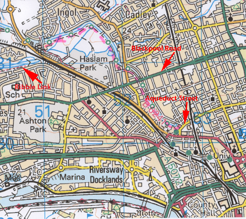
The two Petes - the end of the canal just north of Aqueduct Street.
 The canal originally continued over a now demolished aqueduct to link with a tramway crossing the River Ribble and running to somewhere near Chorley to link up with the Leeds Liverpool Canal. Boats were unloaded at Preston onto that tramway, and then goods reloaded at the other end to continue on the canal - all sounds a bit  laborious, and the cost of construction eventually exceeded what it  would have cost just to extend the canal to Chorley.
Pete and yours-truly celebrating with an uncharacteristic high five

Sunday, 31 March 2013

Lancaster Canal - Hest Bank to Carnforth

This project has been in two halves. I walked the sections north from Hest Bank to Kendal on my own, and south from Hest Bank to Preston with Pete (we still have one more trip to finish at the terminus in Preston).

Originally, walking with Pete had no particular objective other than a regular Thursday outing. It was only when I had done a couple of legs on my own on the northern section that I conceived the idea of walking the whole canal. At that point I knew I had walked the first of the northern sections from Hest Bank to Carnforth several weeks earlier, so I let that count, but now realise that I had taken no photos, nor did I post on the blog. Every other section on the canal has its own post, so  yesterday I cycled and photographed this missing section so that I would have a complete record on the blog.

My bike at Hest Bank

This section mostly runs through pleasant residential territory on one side and the A6 between Lancaster and Carnforth on the other ; the path is hard surfaced as a cycle track all the way

Distant Warton Crag


This was Easter Saturday - one of many dog walkers and casual strollers met along the way just about keeping up with the narrow boat. I must get a better bell for my bike

Close proximity to the A6 most of the way

Moorings at Carnforth

Exit the canal at Carnforth - I cycled back on minor roads

Friday, 29 March 2013

Lancaster Canal and Ribble Link

My last post recorded our continued mission to walk the Lancaster Canal and the Ribble Link, and revealed my puzzlement regarding the continuation of the Ribble Link after the first tier of locks.

Two issues arise: my own failure to look at the scene properly on that visit, and secondly the limitations of the Ordnance Survey 1:50000 map.

Our trip today started a kilometre down The Link from the aforementioned junction with the Lancaster Canal at the point where we finished last time. From that road bridge we followed a surfaced cycle path as far as practically possible. The Tarmac developed into a rough path which was terminated by a tributary flowing into The Link with no easy means of crossing, and no indication on the map that orthodox progress to the junction with the River Ribble a kilometre further was possible.

We returned by the same route then drove back to The Link junction with the Lancaster Canal to try and unravel the mystery.

Looking down the three tier locks and straight ahead the canal apparently continues as an unnavigable stream blocked by a fallen tree, but then we noticed a footbridge going off to the right halfway down the locks, and further examination revealed that the Ribble Link doubles back acutely on itself immediately at the foot of the locks, to flow under the footbridge, followed, again immediately, by a tunnel going under the adjacent road (Tom Benson Way), and straight after this, on the other side of the road another tunnel takes the Link under the railway. A hundred yards or so after that tunnel the path joins the path shown on the OS map which we arrived at by a much more circuitous route last time (see my sketch map).

Chatting with a Waterways worker we were told that the boats are instructed to enter the acute bend at the bottom of the locks in reverse because the space available makes turning unreasonably difficult.

The enlarged OS map below shows a congestion of information, and that there is just no room for the mapmakers to indicate a footpath continuing under the road and the railway. Occasionally the 1:50000 map is just not up to the job, but I still much prefer it to the larger scale 1:25000.

Hopefully we will be out again next Thursday when we will complete this exploration of the Lancaster Canal, when, barring further navigational stupidity, we will arrive at the terminus in the centre of Preston.

The orange marker shows our route which was as far as we could proceed within reason


These guys were not canal workers - they were employed just to lift these Waterways boats out and transport them - they were not very communicative
There is a golf course on the other side


This didn't look high enough for boats to pass underneath - another mystery? Oh no, don't let's start again!


As far as we were prepared (in both senses) to go

The apparent continuation of The Link from the top of the last of the three locks - the Savick Brook was blocked by a tree just after the second arrow. The Link doubles back on itself as indicated by the single arrow. The visible water is not conducive to easy turning of the boats and they go through the hairpin back right in reverse

Click to enlarge
The pink marker shows our original lengthy route.
The yellow marker shows the correct and shorter route
The red dots show public footpath as shown on the OS map

The Link is running under this road. The tunnel under the railway is just beyond the end of the fence on the left

The tunnel under the road and the tunnel under the railway visible behind

Through the railway tunnel. The footpath shown on the OS map commences on the banking beyond, but it is a longer circuitous trip through a housing estate to get there from the Lancaster Canal

Looking back at the three tier locks with The Link doubling back on the left. How we missed all that on our first trip I do not know

The Savick Brook emerging through the tunnel - its continuation at right edge of picture is blocked by a fallen tree

Enlargement of OS map showing the difficulty of showing a footpath going through the road/railway area. The red dots of the two footpaths are visible which explains to some extent the route I took attempting to link them both together

PS - Previously when I clicked on a photo the whole sequence appeared as thumbnails enabling the viewer to see them all as a slide show. Now I seem to have to click each one individually, returning back into the post each time. Anybody got any ideas?

Friday, 22 March 2013

Components of exploration


Thursday 21st March 2013

At the start of an outdoor trip I suppose I hanker after the unexpected, barring outright catastrophe.

There are numerous possibilities. Weather or time may compel plan modification. Interesting highlights may occur worthy of pleasurable Googling back home. Entertaining, objectionable, or bizarre people can be encountered, and then there are miscellaneous unexpectednesses; all these combine with the satisfaction of traveling through an aesthetically pleasing environment and create a unique experience for every outing.

Today we arrived at the Ribble Link on the Lancaster Canal which enables connection with the River Ribble and thereby, after a possibly perilous downriver journey, connection with the Leeds Liverpool Canal, and the UK canal network.

The Ribble Link branches right into a mini marina leading to descending locks, and then a mystery. At the bottom of the locks a shallow, unnavigable stream partly blocked by a tree runs off into the distance.

At home Internet failed to enlighten, and a phone call to the number displayed (see photo) was answered by an office in North Wales, and Ruth, my potential source of information only works Mondays and Wednesdays, so anticipation will be prolonged, unless some enthusiastic commenter intervenes.

Pete and I both value our after walk debriefing in a café, and now, driving further, walking time or café time has to be sacrificed. A conference resulted in a shortcut on the walk (see map), so we could indulge in our new discovery, Café Ambio at the recently built livestock mart near Junction  36 on the M6.

A public footpath took us by concrete steps to a road. I was three steps off the horizontal concrete leading onto the road when a workman across the adjacent railway line bellowed a fortissimo warning not to proceed. The concrete platform had been severed eight feet from the road - the unwary would likely take a painful fall if proceeding. We had to divert over a wire fence into a field and over another wire fence onto the road - no diversion had been fixed.


There is a bit of previous orange route from last time top left corner. Our shortcut is indicated by the pink route

Chacun à son goût
I quite like some of this stuff when it's done well


The Ribble Link going off left (from the south), difficult to photograph...
...leading to this marina...

...and to these locks


At the bottom of the locks there was just a shallow, unnavigable stream?
We wondered which sign came first?


The steps leading to oblivion, taken from the road. We exited field left