Tuesday 22nd October 2024
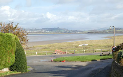
Today's walk had me thinking about local knowledge. Bowland Climber was enthusing about a new guide from Cicerone Press detailing walks around my own domain of Arnside and Silverdale. The guide suggested parking and starting from the Milnthorpe Arnside road at Sandside along the railings of the Kent estuary. When there is a high tide and a contributing wind that road is susceptible to serious flooding. I suggested parking higher up the road leading into Storth village.There is no particular warning that I know of about this and it is an unfortunate omission from the guide. I wonder how often we visit unfamiliar locations and unwittingly launch off without the benefit of some relevant local knowledge.
A short walk back up the road and we were able to double back through the railway cutting footpath. The cutting through solid limestone with a depth of forty feet or so must have been a formidable challenge back in 1876.
The steep exposed rock faces had BC captivated, assessing lines, new routes, first ascents, names in a guide. book, and the like. Some years ago in my Geocaching Period I had told BC about a geocache high up on one of those walls but we never got round to sorting it. Today, thankfully, BC had a look and considered it would need tackling with rope and protection. We moved on.
We passed to the rear of the Ship Inn, now closed and subject to rumours of its ownership by a local property empire builder with some unidentified redevelopment plan.
We made a diversion to view Hollins Well as marked on the OS map - I had been there before. On the way we got mixed up with a dozen or so folk off to annihilate pheasants. We heard their shots for a while as we viewed the less than spectacular stone trough covered with twigs and leaves under a dank wall in gloomy woods. A lady in the shooting party had offered us lemon sweets which I felt a bit guilty for accepting considering my anti "killing things for pleasure" stance.
That all sounds a bit gloomy but weather-wise this was the best for many a day with sunshine and clear blue skies and the best of autumn colours - a good day to be out.
Emerging back onto the road we crossed and followed a loop back to Dallam Bridge following the river Bela where it emerges into the Kent Estuary with expansive views across to Whitbarrow and back down to the Arnside railway viaduct. When the the sun is in the optimum position and the reeds on the far bank of the Bela have turned golden there is the opportunity for a classic photo with the weir in the foreground, the golden glowing reeds to the left on the far bank, and picturesque Dallam Bridge in the background. Somewhere I have that photo but for the moment can't track it down on my Mac photos.
Dallam Estate allows access through its deer populated parkland and gentle climbing gave us more elevated distant views back up the Kent estuary and distant Lake District hills.
Descending through ancient mixed atmospheric woodland BC was keen to locate Dog Hole as marked on the OS map. I had visited previously resulting in a blog post of above average interest which seems to have disappeared, but a subsequent post gives a good summary:
https://conradwalks.blogspot.com/2020/05/the-dog-hole-sd-482-802.html
Also identified on that visit was an ancient oak in the middle of a field which I was given to understand had some designated status. I got a good photo of it today.
Our walk finished back through the village of Storth with its well appointed residences.
As this was a local walk I tended not to record many photos, and overall there is a much more detailed and well written account from BC.
https://bowlandclimber.com/2024/10/24/sandside-discoveries/
 |
| The road that floods and the views up the Kent estuary from our start |
 |
| BC planning first ascents |
 |
| This is just a gate! Note the yellow handle |
 |
| Just right for popping down to the local shop |
 |
| Hollins Well, or perhaps Hollins Unwell? |
 |
| This is an inferior version of the photo opportunity I mentioned above, especially as I managed to miss most of Dallam Bridge |
 |
| In Dallam Estate deer park with the River Bela |
 |
| St. Anthony's Tower above Milnthorpe. When I moved to Arnside over twenty years ago I was compelled to trespass and investigate only to find a dead sheep lying in the bottom |
 |
| The ancient oak tree |
 |
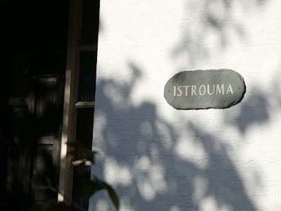
| Unusual house name - Internet came up with: "Istrouma is an unincorporated community in East Baton Rouge Parish, Louisiana, United States." |
 |
| Anticlockwise |


A perfect melange of memories. Thanks for the diversions.
ReplyDelete