For newcomers

At the bottom of each post there is the word "comments". If you click on it you will see comments made by followers, and if you follow the instructions you may also comment and I always welcome that. I have found many people overlook this part of the blog which is often more interesting than the original post!

My blog nick-name is SIR HUGH. I'm not from the aristocracy - my middle name is Hugh which relates to the list of 282 hills in Scotland compiled by Sir Hugh Munro in 1891. I climbed my last one (Sgurr Mor) on 28th June 2009

****************************

Showing posts with label Walking Lakes. Show all posts

Wednesday, 12 March 2014

Deliverance

After what seems like months of climbing stiles, wallowing through mud-bog-gates, encounters with barbed wire, climbing fences, squelching through cattle plugged fields, and pounding the Tarmac, and convincing myself that Geocaching is an acceptable substitute for proper hill walking or long distance backpacking, liberation has arrived.  There was none of that stuff yesterday.

I headed for the quiet part of the Lakes north of the A66, and parked at Stone End Farm to walk the circuit of Carrock Fell, High Pike, Great Lingy Hill and Knott.

That was a 10.5 mile round with a steep ascent to start with, but then mainly high level gentle walking. I saw one person heading in the opposite direction several hundred yards away, and on the summit of Knott, from where I could see The Isle of Man, I met a guy from Cleator Moor who had served in the RAF Mountain Rescue. Immediately after intensive snow and ice training in Scotland, the RAF, in their wisdom sent him out to one of their desert regions for search and rescue.


It was such a pleasure to be on the tops, surrounded by peaks with the odd dotting of snow, cloudless blue sky, silence, heather threatening to bloom, and, on the descent, busy eager streams descending steeply still working hard after all the recent inundation.

Please click to enlarge - at this size the pics are severly challenged


My route indicated by red dots. Carrock Fell summit way beyond skyline


From Carrock Fell summit. High Pike at r/hand end of double arrow


Back to Carrock Fell from High Pike

The back of Skiddaw from Knott.
Knott is another Marilyn - I still have ten unclimbed Ms in The Lakes


Monday, 20 January 2014

A first ascent


Three years ago I was mildly puzzled by people who wanted to talk about, and extol the virtues of grandchildren, but now I am one of them.

Katie is now 2 years 3 months old. On Saturday, along with mother Jill (High Horse), we all made the ascent of the first proper hill for Katie.

Orrest Head, at approximately 750ft is a popular viewpoint above Windermere involving a two mile round trip and 350ft. of ascent, all pretty steep going.

I know it is not so remarkable, but what gave great pleasure was Katie’s obvious enjoyment from beginning to end. Despite a biting wind, rain in the air, and mud underfoot, she walked cheerfully the whole distance. One of my walking poles was requisitioned, and it was obviously too long, so Katie trailed it behind, and told us it was her dog that she was walking. I remarked that there could be a market for walking poles for children until a bit of lateral thinking had me shorten the pole to suit - Katie was well pleased with that.

The weather was hostile on the summit, but no bother to K. She joined in at being pirates looking for treasure when we sought and found the local geocache and she was rewarded with a little spangled booklet which she cherished for the rest of the day.

On the descent K had a little tumble and muddied her jeans, so back in Windermere HH shot into a charity shop and bought a virtually new pair of designer (Joules) jeans for 75p so we were all neat and tidy to finish the day in Café Ambio at The Lakeland Motor Museum.
--------------------

Some of the pics were taken with Jill's iPhone and leave much to be desired.


On the summit
At speed on the descent.
 Note colour difference between my Canon SX150is and Jill's iPhone

iPhone panorama from summit - very pixelated
At Café Ambio
Arriving back at Arnside - nb railway viaduct

****************************************************************


Thursday 16th January

My regular Thursday walk with Pete took us to Humphrey Head setting off from Cedric Robinson's cottage near Allithwaite. Cedric is the Queen's guide for walks across the sands of Morecambe Bay from Arnside to Grange-over-Sands. Some years ago I was on that walk with my old Springer Spaniel, Barney. I was concerned whether he would make it or not in view of his age, but out at the front  was a lady with a little terrier that was on heat and Barney got tucked in behind and never flagged. 

Despite both our ages (Pete is a few years older than me), and not having the same incentive as  Barney, we managed the seven mile round trip in sprightly fashion at an average speed of 2.1 mph including finding three out of four geocaches and taking pics.


Zoom to Arnside Knott 

Tuesday, 10 December 2013

Two walks with two good friends

Pete and I can’t remember cancelling a Thursday walk for weather for a year or more.

Thursday 9:30 am - from my study window, howling gale and lashing rain. I reckon the cancellation phone call is imminent.

No phone call - drive to Pete’s - he gets in  - I suggest cancellation giving him easy option - he is indignant, “it’s only showers” he says. I’m caught on the hop, but  welcome the optimistic stance.

At Levens rain has stopped but wind is ferocious. We have deliberately chosen a short four miler, but apart from being shoved frequently by the wind for several yards in unplanned directions, we only experience one ten minute shower, and even then find  shelter in a barn doorway, and arrive back at the car dry again. 

Coming back into Arnside we find “Road closed” notices, but the combination high tide and high wind has receded and we can drive through with only one section of flood, but Pete’s wife’s art class Christmas party has been abandoned because most people are unable to get there.


Here, and below as a zoom - distant view of our Lake District National Park - for my USA readers: that is an area of lakes, and mountains only up to 3000ft, and about 20 miles east to west and 40 miles north to south. The second part of this post locates in the middle of all that. 


This  was taken on 28th December 2011. On this Thursday, 5th December, water reached a third of the way up the road sign left of picture. Pete's Wife's art class is held in the village hall about a hundred yards up that road

__________________________________________________


Saturday 6th December

My commenter Gimmer is my oldest friend going back to school and scouting days. He studied chemistry and went to Oxford. I went to work.

Gimmer's penchant for chemistry led us to making bombs based on sodium chlorate, (I think), and also something to do with potassium crystals mixed with ammonia. We roamed the Yorkshire Dales and the Lake District, camping, walking, rock climbing, and caving, as well as amusing ourselves by turning off the electrical master switch in the village hall where our soppy contemporaries were dancing. 

In later years we had forays into Scotland, and G accompanied me on the last week of my GR5 trip (Lake Geneva to Nice).  Gimmer lives mainly in the South, but also periodically visits his late parents' house here in The Lakes.

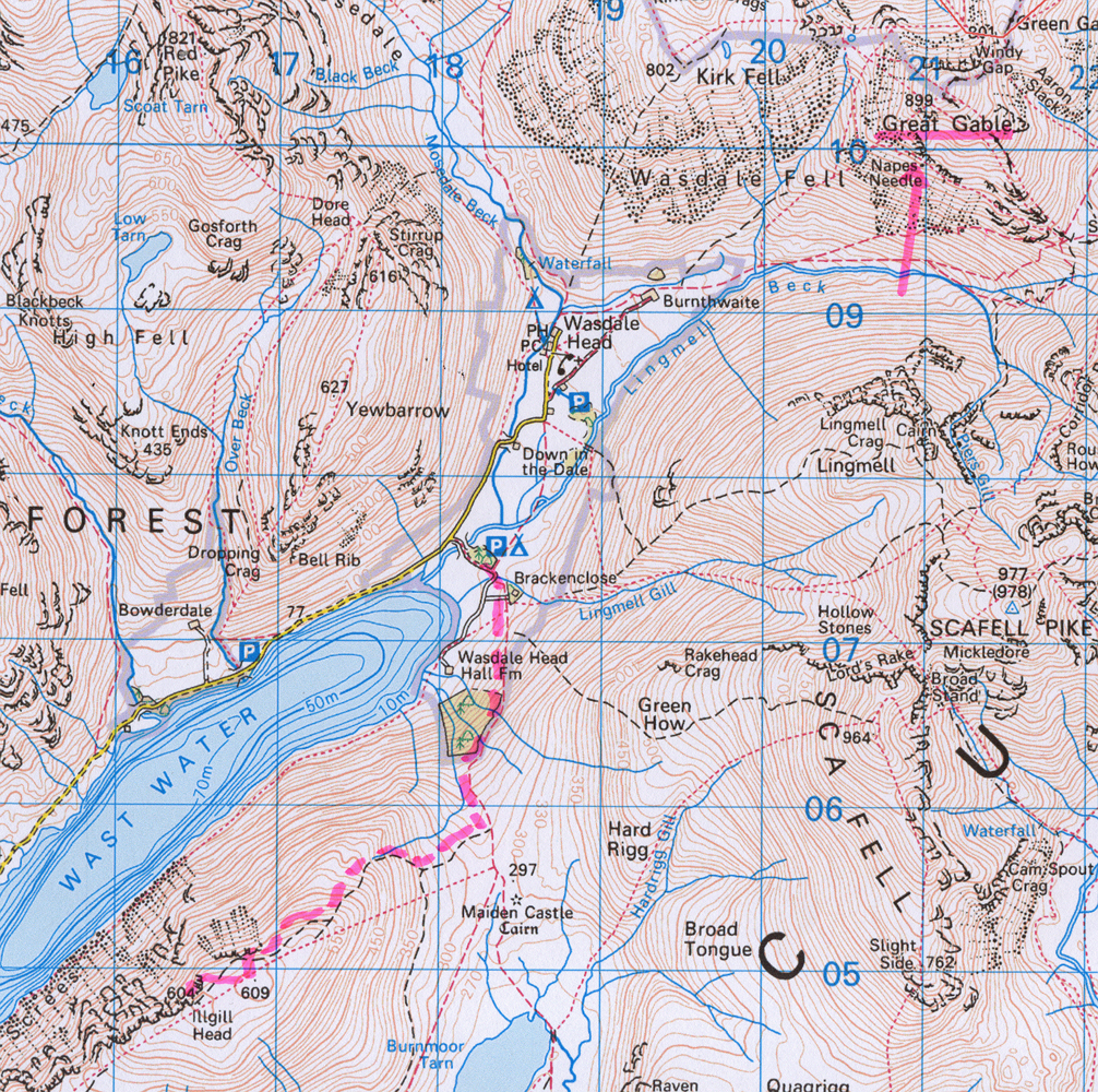
I still have twelve Marilyns unclimbed in The Lakes, so as a means of focus last Saturday, which coincided with my birthday, we made the long drive to Wasdale Head to climb Illgill Head directly above the famous Wastwater screes.

My day was made when, with my recent membership of The National Trust, I saved £4.50 on parking. Unbelievably, ours was the only car there at 10:30am on a Saturday - so much for my frequent grumpy-old-man complaints about the overcrowded Lake District - we met only one lonely fell runner on our round trip.

We visited the traditional and nostalgic Newfield pub in Dunnerdale afterwards, and then back on the LD fringes we had a good birthday meal at The Eagle's Head in Satterthwaite. Almost what some Spanish guys I climbed with would call a dia completo:  a café  coffee meet in the morning, climbing together during the day, and having a convivial meal together in the evening - we only missed the morning coffee.


Great Gable identified:  location of zoom shot below and a major rock climbing venue including the famous Napes Needle


Illgill Head from Wasdale Head car park - the summit is further back. Our route went topside of trees on left
Great Gable - zoom to crags below
Great Gable famous rock climbing location including Napes Needle. The big scree to the left of the crags is Great Hell Gate


On the summit. The pointy one sticking up above the edge is Yewbarrow, one of the steepest ascents in the Lakes.

Saturday, 19 October 2013

Bits and pieces


At a 12 month, (actually 17 months) knee follow, a new surgeon ordered a blood test, scan and x-ray.
Results demanded a fluid sample from the knee. A quick appointment was promised.

After two weeks I telephoned about the appointment. After an hour I had used eleven telephone numbers. The appointment system had blundered.

The new surgeon had re-referred me to my original surgeon, Mr P, who said last week that the scan and the fluid sample were pointless, and surgeon number two didn’t know what he was doing - his actual words!

Mr P ordered an x-ray because he did not have the previous test results, only surgeon number two’s letter.

After the x-ray I was outspoken, which prompted Mr. P to spend half an hour analysing the x-ray and detailing his reasoning, concluding: the joint placement is sound, my pain and discomfort is not unusual, there is no infection present, and as I am able to walk six miles* the operation has been a reasonable success. He saw no point in further investigations. Mr P assured me that if anything needed doing it would be done and I could come back anytime if I had further concerns, and he put me on another twelve month follow up.

I was worrying about further surgery, but I’m now prepared to make the best of it, and already I believe I am benefiting psychologically.

* I was walking fifteen miles backpacking during the summer, albeit with continual discomfort.
----------------------------------------

Three recent outings:

Great Mell Fell and Little Mell Fell ten days ago (two Marilyns west of Ullswater). The weather was so bad no photos were taken.

Thursday 17th October - a walk in the Lune valley with Pete and another Pete.

Friday 18th October - Hallin Fell, (one Marilyn, eastern shore of Ullswater).


One for my "signs" collection. All that work in stone before checking the spelling, unless of course there is a sight on the site

Clay being transported from the hillside to Claughton Manor Brickworks in the valley

Quarry House Farm - under renovation -a remote and windswept place to live

--------------------------------------------------------------

Ullswater north from Hallin Fell

Ullswater south from Hallin Fell

Boredale and Boredale Hause from Hallin Fell
------------------------------------------------------------

Katie update:

from a visit to Wray Castle at the north west end of Winderemere. National Trust have opened all the rooms to include very informal activities for kids - well worth a visit if you are stuck for something to do with the offspring.

With Uncle Will

Moi - Katie was allowed free range with the camera - this is arguably a better effort than the ones of ceilings and floors

K. showing signs of following Mum's footsteps as a teacher


Monday, 14 October 2013

Walking and talking


What possessed the Neolithics (4500 to 2000 BC) to build a stone circle in this desolate location?

What decided farmhouse builders on the location of the slate quarry we explored?

Isn’t it late in the year to find thriving butterfly caterpillars?

Can we remember ever having driven on this remote stretch of single track, unfenced tarmac?

Why don’t farmers put footpath signs through their property?

These and other questions we pose and try to answer as Gimmer and I take a leisurely six mile footpath walk round the lower flanks of Black Coombe.

Other topics:

Defining differences between, concoctions, decoctions and tinctures.

The writings of Thomas Hardie, Elmore Leonard, and Joseph Conrad.

American gun culture and violence portrayed in old Walt Disney cartoons, leading to Gimmer’s chilling account of The Collector by John Fowles. We anticipated defenders of sadistic material saying that it only influenced  "a very small minority" to perpetrate copy-cat actions; well, in a city of say 300,000 one in a thousand that would be 300!

The ability to walk across previously impossible marshy ground now drier through chemical pollution and climate change.

Post war milk deliveries and purchasing of groceries.

Duck and turkey breeding at a remote farm.

The various definitions of the word dike or dyke.

Gimmer’s comparison of planning convoluted circular country walks with our erstwhile pursuit of mountain climbing which only involved deciding which mountain to climb.

Our good fortune at still being able to do even these walks at our advanced years - speculation of a tabloid story of two 70 odd year old men lost on the hills - conclusion:  silly old buffers.

Such is the substance of  walks with a companion interspersed with frequent stops to appreciate views, identify  peaks, take photos, and convivially munch sandwiches and drink hot coffee warding off the now seasonally colder weather.


Stickle Pike, Caw, Old Man of Coniston, Dow Crag and Grey Friar

Traditional sheepfold and the Duddon estuary


Neolithic circle - Swinside - (SD 172 882)

Gimmer christened this The Leaning Lean-to

Monday, 18 February 2013

Connections

Marilyn 280 - High Rigg - NY 308 219

The car park at 9:50 am at Legburthwaite (sounds like a Dickens character) was empty.There is a scale of charges which irritatingly makes you predict how long your walk will take so I had to choose between two hours or four, and had to opt for the latter - £4.50.

Within the first quarter mile I overtook a young couple, and then a group of elderly ladies. In the hills,"elderly" seems to be a relative term depending on how quickly people are walking. At 73 I must qualify for the definition, but I don't put myself in that category. The younger couple were in another familiar category. The man was walking quicker than the girl, and he had to keep waiting for her, so either she was extremely unfit, or just hated walking, and I reckon they would have gone another half  mile before turning back.

Surprisingly, especially as it was  a cloudless, blue-sky Sunday, I had the whole of the tops to myself until dropping steeply off the other end of the ridge. The complex massif of Blencathra scattered with snow dominated, and had me snap-happy. Given the perfect weather and the weekend timing, I had been fortunate - that is the potential reward for an early start.

As I descended to a miniature church I heard the organ playing. After the trauma of the descent, and in no hurry, the idea of a short rest was appealing. There was a convenient bench in the churchyard, and nobody else about, and as I sat music continued, tuneful, melodious, and at a gentle pace mirroring my increased relaxation. This ephemeral moment lasted for several minutes, but it seemed longer, until the music ended, and I heard the  distant sonorous voice of the preacher, slightly muffled and sounding as if coming from the bottom of a very deep well, and  so I moved on.

Low Bridge End Farm has a conservatory converted into a café, sometimes attended, and sometimes serve yourself. I  chatted to the farmer, a well spoken and educated guy in his sixties I guess. His family have been there since 1911, and his father continued walking on the fells until he was 97.

Back at my start the car park was now full. I had not refreshed at the café, and thought I would call elsewhere on the way back, but every lay-by, and pub and café car park was crammed with cars manoeuvring for the next available space, and hoards of people walking everywhere. It would have been more peaceful at Butlins in August.
Top left, Dale Bottom features, where, back in the Sixties The Yorkshire Moutaineering Club had a cottage. We spent many a weekend there. It was basic to the point of disgusting.

All these pics feature Blencathra. Here the summit of High Rigg is beyond the visible ridge

St John's in the Vale


St John's in the Vale church


St John's Beck

Castle Rock.
 One of the best climbing crags in The Lakes where I did a number of routes with Tony including Overhanging Bastion

_________________________________________
Back home I managed to contact the organist at the church after a bit of detective work. The tune was Abbey Sunset written by Harrison Oxley  (decd. 2009) - organist at St Edmunsbury Cathedral, a bit of a maverick. For more info: click here