For newcomers

At the bottom of each post there is the word "comments". If you click on it you will see comments made by followers, and if you follow the instructions you may also comment and I always welcome that. I have found many people overlook this part of the blog which is often more interesting than the original post!

My blog nick-name is SIR HUGH. I'm not from the aristocracy - my middle name is Hugh which relates to the list of 282 hills in Scotland compiled by Sir Hugh Munro in 1891. I climbed my last one (Sgurr Mor) on 28th June 2009

****************************

Thursday 29 September 2022

Trigs 99 - Visit 5

Tuesday 27th September 2022

Raygill House Moor.      SE 091 690.       458m.

6 miles. Ascent 1100 ft. +

Now we are into some quality walking in proper hill country.

Instead of the now tedious route over the A66 to Scotch Corner I am approaching by the A65 Skipton road - always nostalgia fro me; memories of hitch hiking to the Lakes in the late fifties and later driving there most weekends from Bradford.. This is a bit longer approach than that previous route but it doesn't seem so.

From Pateley Bridge the roads become narrower as I head up the lush wide valley of Nidderdale. I park in Ramsgill opposite the Yorke Arms, once a highly rated eating  pub but now only catering for large parties and weddings and the like, and no longer a conventional pub or hotel.

I set off up a private road leading to the farm at Raygill but I have only gone about fifty yards before I am hailed by a woman down near the main road. I had passed her a few minutes earlier where she was just going into the church from her well appointed Range Rover, perhaps "doing" the flowers. She reminded me of Margot in The Good Life.  She turned out to be the farmer's wife at Raygill and told me the road was private . She was mainly concerned that I knew what I was doing and would not be getting lost and she had no objection to me proceeding after I had verified my credentials.

The road was steep with a few hairpin bends but the views back up Nidderdale were superb.

At Raygill I had difficulty getting onto the footpath (not public) marked on the map but eventually I was onto moorland along a gently rising Land Rover track. As indicated on the map this track ended abruptly, tnow marked as a continuing footpath which after a kilometre again terminated on the map. From there I would have to beeline and climb moorland steeply across virgin heather to the trig. That path at the end of the Land Rover track was marked by a substantial cairn which would certainly be a welcome marker for anybody approaching from the other direction. Especially so because the footpath was almost invisible and I lost it for a couple of hundred yards and ended up flailing about in deep heather. 

The one and a half kilometres  continuation from the path end up to the trig was arduous and time consuming. At last the trig was visible standing in lonely isolation in the middle of a huge expanse of moorland, the only object sticking up above the level of the heather.

I headed north to pick up another Land Rover track after visiting the curious collection of large bouldery stones: Ray Gill House Wig Stones. They may be of interest to bouldering aficionados - see  this website:  "Unknown Stones, Wild Bouldering in Yorkshire"

A stop for coffee and a munch and then a walk back on the good track to Ramsgill completed a good walk in magnificent surroundings.

I had researched one other trig a short hop from the road only a couple of miles away. Trigpointing UK informed me of ascents up a private track to lead through a disused quarry and then a couple more fields. I had assumed this would be the most practical route. Parking at the road junction where the track lead off was fortuitous on this narrow country lane.  Up the track I went leading through a field opening to a rusty old iron gate leading into the disused quarry, This gate was propped up by three huge stones. The gate had various metal stakes protruding threatening impalement and it was also leaning awkwardly. I tried to climb over but failed. I wandered up the wall side and found no other weak point. Back at the gate I heaved one of the stones away and managed to open the gate enough to squeeze through - there's always a way?  I trekked across the quarry only to find the only exit was over a low wall with a low non-barbed fence, easy enough to stride over but with an eight foot drop into the field below. The thought of injuring myself and having to call out the boys for help and trying to explain that I was two fields and a quarry into private land, and they would probably need to identify the farmer and gain permission, was a sobering thought and I retreated, replacing the moved stone at the gate. That possibility definitely needs bearing in mind when on private land. Extra care and caution is advisable.

I now looked carefully at the map. I saw that the trig is actually on access land and a short drive up the road identified a gate leading onto that land with an easy walk up to the trig! It was now too late and I will have to leave that for next time but with the research done it will only be a short diversion.


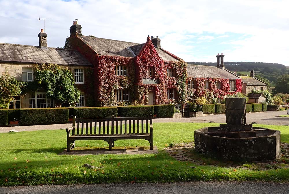
The Yorke Arms, Ramsgill

Looking down to Ramsgill church

Nidderdale

My trig is up there somewhere

Land Rover track, easy going until...

...its termination at this cairn

And some time later after a lot of heather thrashing. Ah! But that is what I came for?


Ray Gill house Wig Stones (perhaps they look like the wigs of old?)


Clockwise from Ramsgill

The second trig. Route from Trig Pointing UK in blue. My researched route for next time in red

That trig in geographical context

Saturday 24 September 2022

A boyhood memory

 I am still battling on making scale models. Each one has to have some resonance with me. The latest completed model is a Harvard RAF trainer. It was also known in Canada as The Texan.

I suppose it was when I was about twelve (circa 1952) that my father would take us three brothers out somewhere on a Sunday afternoon to fulfil his access to us after my parents divorce and we were living with Mother. One of the venues we visited was Yeadon Airfield, a minor affair in those days but important because Avro had a purpose built factory alongside from 1939 where a variety of WW11 planes were constructed and rolled out on Yeadon Airfield for delivery. A short bit of more detailed history,  which is of above average interest, can be seen here : CLICK

Yeadon airfield has since become Leeds and Bradford Airport.

Father was deaf and therefore excluded from regular military service during WW11 but he served throughout manning the Observer Corps station on Otley Chevin with a crew on a rota basis where they would monitor passing aircraft and lookout for invaders. Father therefore had a good working knowledge of operational aircraft at the time.

One of those more or less insignificant snippets that remain inexplicably with one for a lifetime when  much else disappears from the memory was uttered by father in his gruff and authoritative voice as we watched a plane circling in the sky above the aerodrome,

"That's a Harvard, they're very noisy."

With that association and the unusual yellow livery, which I learned was the standard RAF colour for training aircraft, I was hooked when I saw there was a kit available.

Different colour paints have different application qualities. For instance silver demands a black primer. I had forgotten that yellow is difficult to get good coverage and it is best to use a white primer. I used grey resulting in the need to apply more coats of yellow to get good coverage. Scale modelling covers a wide variety of skills, particularly when "weathering" models to make them look realistically used;  learning is a never ending process.

Mine is meant to look as though it has been relentlessly used by many different trainee pilots passing through. 


 Please let me know if there is any problem watching this video.


Sunday 18 September 2022

The Cottage

Saturday 17th November 2022 

A day out with granddaughter Katie and Mum, and Uncle Will.

Fish and chips at The Cottage on the outskirts of Blackpool. A famous venue frequented by many many stars of the stage and entertainment arising from their regular performing in Blackpool, as well as numerous politicians whilst attending their annual conferences. Their photos adorn almost ever inch of wall space. 

We ate at The Cottage as a family when we lived in Preston. That is well over twenty years ago so it was good to find this venue has survived allowing us to  indulge in some family nostalgia.

Photos were taken by Mum except for the final one below so Mum does not appear.

Afterwards we went on to  a "destination' - Barton Grange Garden Centre on the A6 north of Preston. This is a massive purpose built complex encompassing horticulture and all the usual gifty paraphernalia. As we browsed Katie tried on a hat and it so suited her I had to buy it and she was much delighted.

 Later at home I received the final photo seen below from Katie taken by herself on her mobile I think.


Katie with Uncle Will


More indulgence. Just squeezed in after the monster feed at The Cottage


Thursday 15 September 2022

Trigs 99 - Visit 4

Wednesday 14th September 2022

Pillmoor Hill        SE 179 942  229m.

Whit Fell              SE 086 945   411m.

Prospect Hill.       SE 227 967   97m.

This will be the least ambitious outing in this campaign. I am mopping up these three to leave only the hopefully more inspiring seven which will provide a single longer walk (for the sake of it) for each one.

The third listed above was intended as the first. Trigpointing UK told me that permission was given from the adjacent house on a friendly basis. I drove the three hundred yards up the private road. There was nobody about, it was only 9:30 am and I baulked at knocking on the door and decided to call back after visiting the other two.

Pillmoor Hilll was accessed via a field gate from the main road and a plod up pasture lead to a copse surrounded by barbed wire fencing and the trig enticingly visible but untouchable about fifteen feet inside. I carried on south following the fencing until I was able to climb over some wooden fencing without barbed wire and then walk back up the other side. I did not get over the barbed wire into the copse and the trig but I was able to touch it with my walking pole and for me honour was satisfied.

I knew beforehand that Whit Fell was located on a huge military training ground with firing ranges.  My son was impressed and had welcomed the idea of my subversive approach dodging bullets and unexploded ordnance. I was also carried along with that romantic vision. Red flags were flying at intervals closer than those country flags at the Olympics. Warning notices in red were explicit and I couldn't see the excuse of having forgotten my reading glasses impressing some hardened army sergeant/instructor. and then to hit you where it really hurts the threat of £500 fines. My bid for hero status was extinguished. I settled for a zoom photo of Whit Fell.

Back home, and with the help of Photoshop making my zoom photo even more zoomy I found that you could just see the trig  on the summit. Even though it was like coming fourth in the Olympics I gained some satisfaction for at least capturing this trig one way or another.

Back then to Pospect Hill from this morning. Still nobody about. The farmer's wife further down the lane told me the house residents and field owners were out at work, not back till 6:00pm. I was able to enter the field by an easy gate knowing I was unobserved and bag this trig which, rarely on this map, stood in the middle of an elevated filed with views all around. I see on the map High Cowstand Bridge, and Low Cowstand Farm close to each other. I resume the cows at the former worship at a de-luxe consecrated and decorative milking parlour whilst those at the latter in a stripped out nonconformist barn. 

Pillmoor Hill

Whit Fell (out of bounds) - see also below...


 ...Whit Fell.
At least one can SEE the trig in this zoom just sticking up on the
 horizon centre


Ignore blue line - trigs are the green triangles


Friday 9 September 2022

Trigs 99 - Visit 3

Wednesday 7th September 2022 

Lister House  (High Barn)  SE 336 724     72m

Summerbridge (SW of)      SE  210 610   191m

High Crag                           SE 165 628    331m

Harper Hill                         SE 205 700    256m

Oak Bank                           SE 225 774     215m

Ellingstring Plantation       SE172 830      259m

Arklow Hill                        SE184 878     160m

There are differing names for trigs at various sources and differing heights between OS 1:25 and 1:50

Visit One ticked off 5, Visit Two, 6 and this visit 7. There is no way that apparently logical extrapolation will continue. 

I have now visited 19 out of the 29 total, so 10 left to do. Of those there is a group of three which will be done in one hit and will involve the last access from the north via the A66 and Scotch Corner, a route  I have rapidly tired of, especially as it involves uninspiring trips down the A1(M).

After that the remainder can be accessed via the A49, then Grassington and Pateley Bridge. Those trigs mostly cover the higher ground around Nidderdale and lend themselves to separate walks of six miles or so, each in their own right.

Brother RR who comments, nay, generally admonishes here, has taken me to task for ignoring the gift of eccentric place names. Well I can't do much with the plain speaking High Barn, except to wonder at the fate of Low Barn. A handy lay-by a few hundred yards up the road gave a perilous approach before access to the public bridleway through the farm and an arrow straight climb on the  track to the trig. Steely blue cloud cover with hints of silver provided a broody light for decent views of the surroundings.

A slip road into a caravan site on the road south of Hartwith Hil (S. of Summerbridge)l provided good parking. A short walk following a boundary wall up a grassy field led to the trig. The stone walling now uses sqaureish blocks of what I think is millstone grit reminiscent of shredded hands and fingers after a day's climbing at Almscliffe, not very far away. The trig had been decapitated. That would seem to have been done by idiots extracting the surveyor's mounting bracket, to what purpose? It is not obvious but a tube about a foot long extends from the bottom of the bracket down into the cast concrete so if you want to get the bracket out decapitation is the only way. I say "bring back hanging."

Continuing with my recall of rock climbing days High Crag is situated only a few rope lengths away from Guise Cliff which I have a vague memory of visiting once but fifty plus years dims the memory. A pleasant level walk across moorland heather in bloom  took me to an area of rocky boulders, the trig posing on top of one. Wainwright remarked on something similar in Wet Sleddsale saying "On no account should anybody over seventy try to climb this." Of course I heeded not. On descending I sat and shuffled off the edge grazing two of my fingers, one gets more stupid with age. Across the road from my parked car OS informs of Old Wife Ridge. I guess so named sarcastically by New Wife?

Harper Hill involved backtracking. The first approach terminated in a gateless field with a high wall topped with barbed wire. As I retraced I could see a gate giving access to the adjacent field and then another exit gate from there leading to the field containing the trig. To get to that first gate I had to thrash through chest high bracken fearing the worst from ticks and eventually arriving sweaty and bothered but the problem was solved. The trig was hidden again, as many seem to be, in a wood requiring a tricky stride over a barbed wire fence which had obviously been savaged to some extent by earlier trig baggers. I can only presume the wood was not there when the trig was founded.

Oak Bank tested my navigation when I missed the turn off the main path involving more backtracking. Yet another low and savaged barbed wire fence had to be negotiated but 'twas no great problem.

Ellingstring Plantation was the most straightforward of the day. A lay-by opposite a fancy pumping station building gave good parking. An open gateway into the trig field was a gift and a short there and back had this one sorted within less than fifteen minutes. There is a plaque on the trig from The Yorkshire Volunteers - they are an organisation for Territorial volunteers. Internet gives some information. I could find nothing about what I think is an erstwhile permission from Ordnance Survey to "adopt" a trig point. I think it was discontinued.

I had read of difficulty of getting to Arklow Hill on TrigpointingUK website because it is on private land with a house in proximity of the field but the field not owned by the resident so he can't give permission. Having said that one is stumped to access from what would be the most convenient point. I parked at a barn further up the road with gate access to the trig field. There were about twenty cows in the field with the odd calf. I skirted round walking slowly and calmly never advancing directly towards any animal. As I closed in on the trig the cows started following me but in gentle and curious manner only. They watched me taking my obligatory photo - I think it was the highlight of their day. I returned to the car without incident.

I pressed the sat nav in my car for "home. Bearing in mind I was located in a maize of minor single track roads with  many options for getting back to civilisation and good roads the sat nav took only about two seconds to calculate the route of around a hundred miles and its prediction of arrival time turned out to be within two minutes. How does it do that?


These photos do benefit from click to enlarge

On the way to Lister Hill. The trig was just at the top 

Lister Hill trig with the broody sky

From the caravan site car park for Summerbridge

A change from the limestone drystone walls

The vandalised trig at Summerbridge, and general view therefrom below


Starting point for High Crag

High Crag trig, and below


Harper Hill - outward route red arrow to the wall and return blue, see map below


Harper Hill trig in its wood 

Oak Bank  - I had to climb the barbed wire fence to the left.

Strange pumping station building at the start for Ellingstring Plantation

Ellingstring Plantation

No specific info. about this found on the Internet

Arklow Hill, "Are you looking at me"

NB shortcut over stubble field on the return


Guise Cliff across the way


Pink shows road journey