
Sunday, 22 December 2019
AT LAST
At last somebody with clout (Yorkshire Water) is waking up to the management of our moorlands for the sole purpose of grouse shooting. That activity exterminates all other wildlife mercilessly purely for the benefit of THOSE WHO ENJOY KILLING THINGS.
Please follow the link below:
CLICK HERE
Wednesday, 18 December 2019
Christmas cards
Wednesday 18th December
Hare are my two favourite Christmas cards (so far.)
I have chuntered on about stiles all year in my blog posts and during my frequent walks with BC to such an extent I reckon, that it must have registered with Gimmer, another good friend who comments here often. I guess they have heard enough from me about those stiles that try to make my robotic knees bend more than they want to, and those designed to take advantage of my diminishing ability to balance, and those with steps covered in lethal, slippery green algae, and worst of all those that are in a state of disintegration - an accident waiting to happen. This stile has comfortably spaced steps, appears to be well constructed and has high handholds to nullify questionable balance and I wouldn't be surprised to find out that this card from Gimmer was a joint effort along with BC hopefully suggesting I find nothing but such stiles and therefore stile-heaven during 2020.

Number two is from my neighbour and is entitled "Just out of reach."

First of all I like the design. It reminds me of helping Big Brother RR with the design of a cover for one of his novels which had an aeronautical background. We had a suitable photo of an aeroplane and messed about with it for ages. Eventually we had an epiphany when we realised we didn't have to show the whole of the image. As an aside this is a good read and available on Amazon (see my review) - a good little puff for my writer brother eh?
The card photo cleverly only shows part of the dog and part of the tree concentrating the viewer's attention on the essentials.

Secondly, I have always had a soft spot for dogs.
Thirdly, there seems to be something symbolic and profound about this image and its title which had me thinking about interpretations for "just out of reach" giving the card much more potential meaning than initially realised.
Wainwright’s Way - final
Monday 16th December
Wainwright’s Way - Hornby to Wray
This one and a half mile stretch was the last part of Wainwright's Way I had left to do.
It was convenient to start from Hornby and walk south to Wray, the opposite direction from all previous sections except for the penultimate section with BC from Wray back to where I finished after picking up the northern end of Salter Fell Road.
I took a few photos which I produce here as though I had walked south to north. I am not sure why I have felt it necessary to arrange that way, I can only assume it satisfies some mild version of OCD which I recognise in other aspects of my daily life and routines. Having said that Wainwright himself published his Pennine Way Companion to read in the reverse of his recommended direction from south to north. W gives an explanation for this which revolves round the difference between reading a map from down to up or vice versa and whilst I can see a glimmer of logic to this I see it as just another example of W's quirkiness we followers enjoy.
 |
| This was the location in Wray where my walk with BC on the penultimate section (north to south) started |
 |
| 16th Century cottages in Wray - see lintel below |

 |
| Wray main street |
 |
I have recently taken interest in unusual house names. This one relates to:
1. A charity for homeless children in Kenya - https://www.karibuni.org.uk
2. An adventure tour operator in the Uk. http://www.karibuni.co.uk
3. Translation from Swahili = welcome
|
 |
| Hornby Castle originally dating back to 13th Century - the building here is from 16th Century - lots of history including connections with The Gunpowder Plot if you care to Internet search |
 |
| The river Wenning flowing right to left towards Hornby on its way to join the river Lune |
 |
| The blue route shows my return by road |
Sunday, 15 December 2019
Christmas and New Year greetings.
Have a good Christmas and good New Year everybody
Thanks to all my commenters
Keep on blogging

--------------------
But watch out for this impersonator coming down your chimney.
 |
| Yo-ho-ho, I've got loads of prezzies for you but you'll have to give me the shop they come from first. |
Sunday, 8 December 2019
80
Sunday 8th December 2019
A few days ago, much to my surprise I arrived at fourscore years.
This being the nearest weekend, son daughter, and granddaughter Katie took me out for lunch.
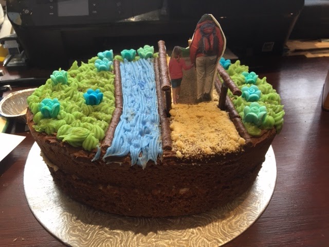
When I was picked up I was presented with a magnificent cake made by Katie. I was emphatically assured that the whole design and making of the cake with its decoration was conceived and made entirely by Katie. Mum said she had no input apart from taking photos of work-in-progress
I am depicted walking with Katie, see clip from photo, alongside a river on a hardcore path, the latter made from crushed shortbread - Katie knows that shortbread is one of my favourites, and as marmalade is another it was so filled in the middle. She also gave me a card with a message saying "I love woking (sic) with you," she is better at cake making and design than spelling (for the moment?)


A few days ago, much to my surprise I arrived at fourscore years.
This being the nearest weekend, son daughter, and granddaughter Katie took me out for lunch.
When I was picked up I was presented with a magnificent cake made by Katie. I was emphatically assured that the whole design and making of the cake with its decoration was conceived and made entirely by Katie. Mum said she had no input apart from taking photos of work-in-progress
I am depicted walking with Katie, see clip from photo, alongside a river on a hardcore path, the latter made from crushed shortbread - Katie knows that shortbread is one of my favourites, and as marmalade is another it was so filled in the middle. She also gave me a card with a message saying "I love woking (sic) with you," she is better at cake making and design than spelling (for the moment?)
Please click first photo to enlarge


 |
Lunching out after receiving the cake.
It was all an enjoyable surprise. I am just as soppy a grandpa as all the people I met and was puzzled by who eulogised about their grandchildren before I happily joined the club.
|
Monday, 2 December 2019
Thwarted - Wainwright's Way - Wray to Wray
Wainwright's Way - Wray to my previous furthest, just after Salter Fell Road (footpath bridge) and back to Wray
Approximately 5.5 miles
The plan:
Meet Hornby - 2 cars
Drive my car to my previous finish parking (SD 600 639)
Walk back to Hornby via permissive footpaths up Roeburn valley back to Wray and Hornby
---------------
Actual:
Drive Hornby to halfway to my previous parking.
Aborted halfway after ascent of ice covered steep hill which would have been followed by steep descent on similar.
Decision: to avoid bringing BC''s car on these potentially dangerous roads - drive my car back to Wray and start walk from there.
--------------------------
Ascending the steep hill after leaving Hornby I only just made it on the ice by zig-zagging and we decided to return very carefully back to Wray.
We walked past the old school in Wray - a plaque commemorates its benefactor and I researched a bit more courtesy of this website - http://wrayendowed-school.co.uk/?page_id=48
The Trust dates back to 1684 when a local lad, made good, returned to the village. Captain Richard Pooley had risen through the ranks of Cromwell’s Round Heads during the English Civil War. He bequeathed a sum of money to be used for the benefit of the school. This was the basis of the current trust.
As at November 2014 the current trust chairman is Bob Smith, who will happily answer any queries anyone may have. Contact can be made by telephone, 015242 22079 or e-mail ritasmithwray@googlemail.com
We had read about the bothy which is marked by OS and we diverted to go and have a look. The approach was over a heart stopping, swinging suspension bridge with ice on the wooden foot slats and we crossed with much laughter and fun - I wisely let BC go first.
The bothy is a large two storey stone built kind of barn but we thought it must originally have had a more sophisticated purpose. It is entered on the second floor by steps to access a dormitory with bunk beds and descent by a vertical iron ladder fixed to the wall to a living and kitchen room below which is pretty well equipped - all was clean and tidy. We were puzzled because we could find no other access to this bothy other than the footpath and perilous bridge by which we came and humping Calor gas bottles and other large heavy items would be arduous to say the least. I spent some time on the Internet trying to find out more but it seems to be a well kept secret.
Returning by the bridge we picked up the path which now ascends high into the woodland then out onto open fell-side before descending where we eventually found the footbridge where I had not crossed on my previous section opting to climb out back onto the road. We crossed the bridge back to that side and walked back on the path and then climbing back up fields to the road a bit further south than my previous exit. Walking back the surface was still frozen on the difficult road ascent from the morning and I was able to photograph my zig-zag tyre marks still there with no hint of there having been a thaw by the winter sun which had prevailed for the whole of our walk.
I thought this walk was going to conclude my Wainwright's Way but because of our altered plan I still have about one and half miles each way between Hornby and Wray to complete.
 |
| The old school in Wray |


 |
| Just out of Wray before entering the wooded valley proper |
 |
| I think I'll wait until I'm in the mood to consult the register |

 |
| The bothy is almost visible in the distance. BC sets off... |
 |
...gets halfway and decides to return.
We then had a vote whether to proceed and we both went on to explore the bothy and then return to pick up our path again
|
 |
The bothy.
I converted to b and w because the original photo had a lurid blue hue giving a false impression - this is much more representative of the chilly day
|
 |
| The living room/kitchen on the ground floor |
 |
| BC descends from dormitory to ground floor |
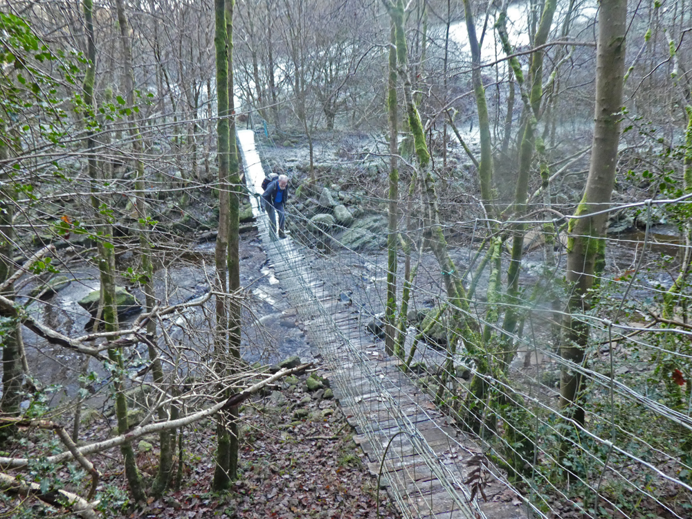 |
| We returned over the bridge now with a bit more confidence but the swaying was still unnerving |
 |
| On our returning walk out my zig-zag marks were still pristine on the road from the morning |
 |
Actual walking route in red.
Blue circular my previous section.
Green AW's Way GPX
Top blue iugnore |
 |
| Yet another shot of Ingleborough. The Panasonic TZ 80 is now refusing to focus when on zoom and intermittently refusing to display the image in the viewfinder when the weather is cold - looks like another of those unsatisfactory guarantee claims looming? This is one of its better attempts at focusing. |
Saturday, 30 November 2019
Wainwright's Way - Dunsop Bridge to Salter Fell Road
Friday 30th November Wainwright's Way
Dunsop Bridge to Salter Fell Road - 11 miles (there and back)
BC had previously walked W's Way from Dunsop Bridge to Hornby. In my last post I walked from the northern end of Salter Fell Road to part way to Hornby and tomorrow (Sunday 1st December) we will both walk the remainder of that part to Hornby. That will leave me the section from Dunsop Bridge to Salter Fell Road as now described. With BC we had previously walked the whole length of Salter Fell Road during our Lancashire Witches walk in June 2016.
------------------------------------------------
A toughy seemed likely based on BC's warning of rough going up Whitendale (he wasn't kidding.) Facing eleven miles there and back including the rough section and diminishing daylight hours I needed an early start.
Drama started before the walk. My drive through and over the Trough of Bowland encountered patches of ice. My Kia Ceed GT Line is really a sports car in disguise and not the best on that kind of terrain. I was gripped several times descending over ice. I vowed not to return that way.
A frosty 8:10 am start treated me to surreal glowing-orange light on the Bowland hills with a carpet of white frost in the foreground.
But for the pre-warning the first five kilometres would have lulled me into thinking this was going to be a cinch. I had been on a private water-board (I think) Tarmac road. Just after Whitendale Farm a gate lead onto virgin fell. A board walk off to the right mislead me especially as it conformed to the GPX route I had downloaded from the Long Distance Walkers Association's website. I tried to follow that route but the path soon faded and I was quickly tackling monster sized tussock grass and wasting time and energy working back towards the stream and finding the proper path. Later, when I was returning the path of course went right back to the gate.
It seemed unfair having to return back down Whitendale after all that effort but there was no alternative. The surroundings on the walk had been spectacular and perhaps worth the effort, but I don't think I will be walking up Whitendale again


Dunsop Bridge to Salter Fell Road - 11 miles (there and back)
BC had previously walked W's Way from Dunsop Bridge to Hornby. In my last post I walked from the northern end of Salter Fell Road to part way to Hornby and tomorrow (Sunday 1st December) we will both walk the remainder of that part to Hornby. That will leave me the section from Dunsop Bridge to Salter Fell Road as now described. With BC we had previously walked the whole length of Salter Fell Road during our Lancashire Witches walk in June 2016.
------------------------------------------------
A toughy seemed likely based on BC's warning of rough going up Whitendale (he wasn't kidding.) Facing eleven miles there and back including the rough section and diminishing daylight hours I needed an early start.
Drama started before the walk. My drive through and over the Trough of Bowland encountered patches of ice. My Kia Ceed GT Line is really a sports car in disguise and not the best on that kind of terrain. I was gripped several times descending over ice. I vowed not to return that way.
A frosty 8:10 am start treated me to surreal glowing-orange light on the Bowland hills with a carpet of white frost in the foreground.
But for the pre-warning the first five kilometres would have lulled me into thinking this was going to be a cinch. I had been on a private water-board (I think) Tarmac road. Just after Whitendale Farm a gate lead onto virgin fell. A board walk off to the right mislead me especially as it conformed to the GPX route I had downloaded from the Long Distance Walkers Association's website. I tried to follow that route but the path soon faded and I was quickly tackling monster sized tussock grass and wasting time and energy working back towards the stream and finding the proper path. Later, when I was returning the path of course went right back to the gate.
 |
Green = already on OS plus GPX route downloaded, but not apparent on the ground.
Blue = the route I took across rough ground.
Turquoise = actual path on the ground used on my returm
|
"Path" was almost a misnomer. Its only merit was just being able to identify it; I couldn't see where my feet were going because it was overgrown and uneven underfoot, and it switchbacked up and down requiring continual awkward stepping. Progress was disappointingly slow. The downloaded route did now coincide, but further on it diverged crossing a fence line to the right but that was not apparent on the ground. I continued on the known option of what I could see. Further on the OS 1:25 indicated another path off to the left, but as mine was intermittently furnished with marker posts I carried on. My path eventually emerged onto the Salter Fell Road between the OS marked path and the downloaded GPX route.
It seemed unfair having to return back down Whitendale after all that effort but there was no alternative. The surroundings on the walk had been spectacular and perhaps worth the effort, but I don't think I will be walking up Whitendale again
Worth clicking to see enlarged


 |
| Hornby Road is the same as Salter Fell Road |
 |
| Looking back at my route up Whitendale - there is more round the back of the distant central fell |
 |
| Two red lines near finish show OS !:25000 path on left. My route on right, and green is the downloaded GPX route. Ignore all other marks scattered about on my computer Memory Map. |
Monday, 25 November 2019
Wainwright's Way (catch-up)
Sunday 24th November 2019
Salter Fell Road to south of Hornby
Rationale - a bit boring put here for the record.
BC, my companion and instigator for walking W's Way has already walked the section between Dunsop Bridge and Hornby - I needed to catch-up.
The total distance is too much for one day, and even if it was contemplated car logistics are not practical.
Dunsop Bridge to the start of Salter Fell Road as a there and back is ok parking at Dunsop Bridge and that will now be my final section - I have previously walked the length of Salter Fell Road recently with BC when we were completing The Lancashire Witches Way - CLICK HERE - it happened to be Saturday 25th June 2016, the day after The Referendum.
That leaves the section from the north end of Salter Fell road to Hornby and today my plan was to walk part of that to reduce the total distance which will need to be double as a there and back.
W's Way by Nick Burton uses the road continuing from the end of Salter Fell but BC had discovered a new permissive path following the River Roeburn for a couple of kilometres before rejoining with Burton's route at Beck Farm.
----------------------------------------
Sunday morning and I had done various household chores by about eleven and on impulse decided to go and walk the bit of Tarmac from a known parking spot where BC's permissive path started up to the start of Salter Fell Road. As this was all on Tarmac and no rain was forecast I couldn't be bothered changing and jumped in the car already wearing approach shoes and a decent pair of M and S chinos.
A quick glance at the map had me thinking that would be easy walking but I ascended about five hundred feet in one and a half kilometres, sorry about mixing metres and feet but that's they way I think. All was quite pleasant as I passed Lower Salter, Middle Salter and Higher Salter farms. At the end of the Tarmac I saw the footpath we had followed on the Witches Walk. At Higher Salter Farm there was more than usual noise from farm dogs and I looked over the wall to see a large cage structure with half a dozen or so collie sheep dogs all giving voice - all looked clean and tidy and I assumed the farmer breeds these as potential One Man and his Dog competitors, or just for daily farming work - it is one of the joys of walking in the country to see these working dogs perform.
Back at the car I was now tempted to reduce the rest of this section more by walking part of the newly discovered permissive path so it was over a ladder stile and onto squelchy muddy field walking - those M and S chinos will never be the same again. The path was fine and eventually dropped down steeply to run alongside the R. Roeburn through autumn tinted woods. I came to a bridge and as no paths are marked on the map this seemed to take me to the wrong side of the river as far as I could tell so I stayed this side and exited up steep banking through the woods to a gate and then fields to arrive back on the road and AW's route proper at the track to Thornbush Farm. That now leaves a comfortable there and back trek from Hornby. I walked back down the road to my car and finished this little trip at The Hornby Tea Rooms for a pot of tea and a jam scone.
The chinos went into the wash and then the dryer - I am now going to the garage to assess the result - my Mountain Warehouse trail shoes had kept my feet dry. What a lot of writing for such a mini walk.
 |
| Salter Fell Road 1.5 km ahead - the start of the permissive path is just behind the camera |
 |
| Just round the corner from the car - pleasant autumn walking |
 |
| Not rare - just sad |
 |
| High Salter Farm - gate in wall is footpath we took on Lancashire Witches Walk |
 |
| Doesn't look familiar to me but Alan R may classify it as not rare? |
 |
| Want to buy a collie to round up your sheep? |
 |
| Lower Salter Farm on the way back - looks like a new wing built on with solar panels |
 |
| On the permissive path not marked on OS map - just before misleading bridge. The path had been well marked up to that point but no markers on the bridge or beyond on my side |
 |
| Hornby Tea Rooms - a bit quiet on this dingy Sunday afternoon |
 |
| Green is official AW's Way. I have shown my day as two separate sections |
 |
Overall view of this logistically difficult section of AW's WAy.
My final completion will be there and back from Dunsop Bridge to Salter Fell Road (halfway up right side of map where it says Croasdale. We previously walked over Salter Fell Road on the Lancashire Witches Walk. I will now have to do a there and back from Hornby top edge of map) to the northern limit of my blue walk today. Ignore trig point markers - the red flag on the "o" of "Forest" is claimed to be the "Centre of England" (or British Isles or whatever) - a subject leading to intense complexity by mathematical and geo-happy nerds - Google if you want.
|
Subscribe to:
Posts (Atom)


