For newcomers

At the bottom of each post there is the word "comments". If you click on it you will see comments made by followers, and if you follow the instructions you may also comment and I always welcome that. I have found many people overlook this part of the blog which is often more interesting than the original post!

My blog nick-name is SIR HUGH. I'm not from the aristocracy - my middle name is Hugh which relates to the list of 282 hills in Scotland compiled by Sir Hugh Munro in 1891. I climbed my last one (Sgurr Mor) on 28th June 2009

****************************

Showing posts with label M6Borrowdale. Show all posts

Wednesday, 19 December 2012

Three miles too far?


Years ago, from the M6 motorway, I spotted the mysterious  entrance to a valley just south of Tebay. Once seen, it was a must explore objective.

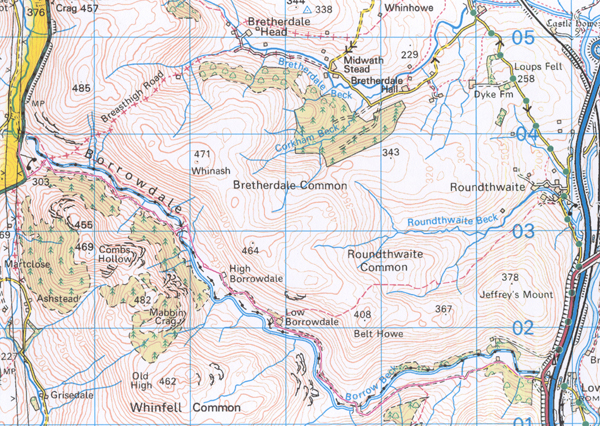
Borrowdale is the small secret cousin to the well known dale south of Keswick. A track, mostly unsurfaced winds up the valley for nearly  five miles from the M6, passing a remote farm halfway and continuing north-westwards to meet the old A6.

The River Borrow continues over the road for another two and a half miles to its source in the wild and rarely visited Shap Fells. I have walked and run the main valley and its northern and southern ridges on several occasions, and the whole area is pure delight. I have never followed the river on the other side of the road, although I have roamed the Shap Fells nearer the source of The Borrow.  A circuit following the river and returning via Bannisdale to the south looks inviting, although there is no continuous path marked on the map, and it could be rough going in parts.

In 2009 a planning application was submitted for a holiday/timeshare cabin village to be built in this dale which would have destroyed its rare solitude forever, but after strong objection permission was fortunately refused. 

Yesterday, in pursuance of flat walking, in consideration of my recovering knee, I walked from the A6 through to the M6 end and back, a distance just short of ten miles. That was further than I have walked since the op, and my inclusive speed was 2.8mph so the knee was painful by the end, and I was overwhelmingly tired that evening, but it had been a more than worthwhile trip re-acquainting myself with an all time favourite venue.


Just after the start looking down Borrowdale towards the M6 end

Looking back to the start. The straight line of the A6 is seen cutting across the centre of the background.
There is much criticism of windmills these days, but what about these three pylons of yesteryear? Click to enlarge for a clearer view of their intrusion on the landscape.

Looking back again towards the start. The peak in the centre is just on the other side of the A6 - High House Bank, 495m.

Low Borrowdale Farm - the halfway point. As far as I could see it was unoccupied, but the barn has had a new roof

The track crosses the stream and becomes Tarmac about half a mile from the minor road near the M6 which leads up to Tebay.

Another one for my "Relics" folder. The colour of the rust was almost surreal.