For newcomers

At the bottom of each post there is the word "comments". If you click on it you will see comments made by followers, and if you follow the instructions you may also comment and I always welcome that. I have found many people overlook this part of the blog which is often more interesting than the original post!

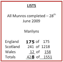
My blog nick-name is SIR HUGH. I'm not from the aristocracy - my middle name is Hugh which relates to the list of 282 hills in Scotland compiled by Sir Hugh Munro in 1891. I climbed my last one (Sgurr Mor) on 28th June 2009

****************************

Thursday 28 April 2022

Blease Fell - Tebay

 Wednesday 27th April 2022 - Blease Fell from Tebay

It is 8:15 a.m. I have just arrived in Tebay wearing shorts motivated by a balmy, warm spring day yesterday signalling time for me to put long trousers into hibernation  but  I have been sandbagged. My car gadgetry tells me it is only 2 degrees outside. There is no hurry and I remain cocooned in the comfy warm car and steal a cup of coffee from my flask at the risk of depriving myself later.

I am here to break new ground on a venture into the northern edge of the Howgills and see what I can see. The Old School is opposite my car and I wonder about its history because of a blocked up arch in the gable end.

Back home I have just Googled hoping for some academic treatise on that architecture. I find that this is now a guest house and it has more first page entries from every accommodation website anybody has ever heard  of, and after five pages I gave up - no mention of its potentially interesting erstwhile life.

Off I plod up a tarmac lane climbing steadily. At  the farm of Tebaygill there is a significant example of corrugated iron architecture in the shape of a barn with a curved roof. Skilful use of that material can produce characterful buildings - this one is only hinting at that possibility, but enough to catch my attention. They are obviously much prone to rust which I guess is a problem for their owners, but something I find attractive with that vibrant colouration.

The tarmac gives way to a rough rocky old lane and the surrounding terrain is that of tussocky pale green and fading yellow grass. No heather on this upland, and as I branch off on a quad bike track to follow the high ground walking is easy. The gradient is steady allowing for non-stop ascent so that when I eventually stop to look behind the view is surprisingly dramatic. I am looking down the long undulating slope back to Tebay, and off to my left I can see the M6 threading through the Lune gorge. The cars are like ants and I wonder if their journeys are more purposeful than those of the industrious insects.

Further on I get a  new elevated view looking up the whole length of Borrowdale (not the Lake District one) and I can even see through to the  old A6 Shap road. Borrowdale is one of my favourite locations. I discovered it years ago by chance rather than recommendation from elsewhere. One's own discovery from exploration is  part of the raison d'être for for this business of walking and absorbing the landscape.

My furthest south finds a jolly little cairn of white stones on Blease Fell, located to obtain the best view of the Lune gorge with it eponymous river, the railway and the M6 all fighting for space. Further to the left I am looking into the heart of the Howgills with Carlin Gill prominent and the deep cleft of Black Force. That was the scene of an exciting day with Bowland climber in September 2019 CLICK HERE 

I spend a while looking at the contrast of timeless hill country against modern intervention thrusting and intruding. I move to slightly higher ground following my GPS eventually having its cursor  over the Ordnance Survey spot height on the map ( 474m.)

Quad bike track has to be vacated for a cross country trek over mildly tussocky terrain to soon join another track leading to Hare Shaw (472m.) Once one has gained height in the Howgills many subsequent summits can be visited by gentle ascents.

From Hare Shaw it is downhill all the way back to Tebay, but I stop halfway for a sandwich, coffee and nibbles. Up until then my hands have been cold even with a pair of modest gloves but at last the sun has made some impression, so much so that I find I have extended my lunch stop by nodding off for a while. There has been nobody about all the way - all is peace, and the only sound comes from the odd skylark.

Well that's some more new and worthwhile ground explored and my early start has left  time to make a long promised visit further north to my friend Gimmer, who comments here, we have known each other from schooldays, I shy at saying exactly how many years ago!
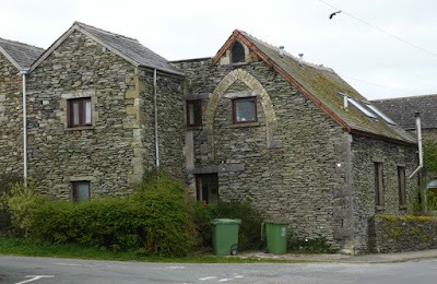

The Old School (guesthouse now) with the record number of accommodation first page entries in Google I have ever come across, I gave up after five pages.


Corrugated iron splendour.
 Blogger is havng one of its tantrums and will not let me dispense with the underlining despite using "clear formatting" which when I tried deleted the photo as well. I have better things to do than spend the rest of the day trying to sort it.

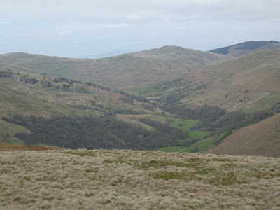
Ty[ical of much of hill country scenery. Perhaps the advent of quad bikes has reduced the need for storage facilities and the like in the more remote parts of these sheep rearing hill farms

Extensive tree planting in Tebay Gill

The quad bike track now left for a less well defined version

Walking was on an easy gradient and I was feeling fit and it was longer than usual before I stopped to look back at my outward route surprising me by its extent


Borrowdale. The light was dingy. This could be a better photo on a day of more amenable weather

This unsightly stuff carried on over a few hundred yards. If it had been effective for the quad bikes I suppose it might have some justification but it was apparent that such was not the case.


This and next - the  Lune Gorge and the M6, Blease Fell cairn in the foreground, and next but one looking to the left...


...into the heart of the Howgills - Csrlin Gill and Black Force. This one for BC

On the way back. That must be the Solway in the distance


Friday 22 April 2022

Smardale from Ravenstonedale

 Thursday 21st April 2022 - Ravenstonedale Smardale circular - 7 miles.

Smardale Bridge features on Wainwright's Coast to Coast  which I walked in April 1990 (32 years ago!)

In 2003 I had a mountain bike ride that passed by. 

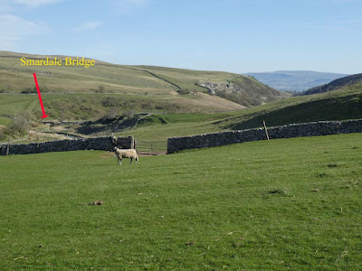
This packhorse bridge from the 1700s has an attraction way beyond its modest construction. It is the way it nestles  comfortably into its surroundings like an aged gent settled into his old armchair, and it is then enhanced by the special cropped greenery of the limestone country with dashes of white and grey here and there where that rock protrudes. Whichever direction you approach from it reveals itself unexpectedly a long way down in its hollow.  When you arrive, which you will, because this is also a crossing point of several routes, adding again to its significance, you will note the old cobbled humpback surface and wonder at those old drovers taking their livestock miles and miles to sell down the country.

Scandal Beck runs below, now a decent sized river after  a short journey from its source on the northern slopes of the Howgills. That beck carves an ever steepening sided gorge necessitating construction of a splendid viaduct for the railway in 1861.

It was built in 1861 by the Cumbrian engineer Sir Thomas Bouch as part of the South Durham & Lancashire Union Railway, which crossed the Pennines to carry coke to the iron and steel furnaces in the Barrow area and West Cumberland. The line was closed in 1962 after steelmaking finished.   Thanks to Visit Cumbria

I have a strange concept about Scandal Beck:  it seems (to me) in parts to be flowing the wrong way in relation to its surrounding landscape.

The bridge, gorge, and the viaduct have provided for a variety of footpaths and walks which have become classics and "must dos" for many a walker, but it was only when I perused a recently purchased Cicerone guide that I realised that possibilities extended north to Smardale and return could be made by traversing the viaduct which is not marked as s public right of way on the OS map, but its length from Smardale south to Smardale Bridge has been incorporated into an accessible nature reserve.

My circular walk was all quiet and peaceful and as good a seven mile circular as you could have anywhere in the country. I expected this to be a popular trek but I only met two other couples the whole way so what has happened to those many many people that walk the Coast to Coast? I am not complaining of or welcoming the dearth of fellow walkers, just informing.


WORTH CLICKING ON PHOTOS TO ENLARGE

    8:30 a.m. start in Ravenstonedale


Ravenstonedale church. I tried to visit on the way back but it was closed


Smardale Bridge comes into view far down below after topping the distant horizon


Note the cobbled pathway


Distant Smardalegill viaduct which I would cross on the return leg

Zoom to same

Smardale Hall
Smardale Hall is a hall house built in the 15th and 16th centuries. The hall has a tower at each corner, very medieval in appearance. There was originally a 14th century tower house on the site, but much of this was demolished to enable the building of the present hall. Some of the original fortified dwelling is built into the current structure. There are earthwork remains of another medieval house in the grounds of the hall, as well as the earthwork remains of a probably medieval motte.Thanks again to Visit Cumbria
 

This is the more modern main line Smardale Viaduct just north west of Smardale village not to be confused with the walkable Smardalegilll viaduct - see next photos.

On the dismantled railway on the way to Smardalegill  Viaduct

Smardalegill viaduct


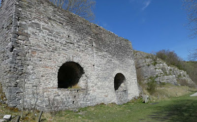
Lime kiln. NB quarry adjacent

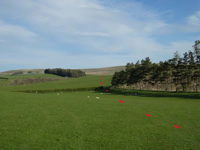
Having left the railway track Smardale Bridge comes back in view. Yellow dots my inward journey and red my return

Scandal beck on my way back into Ravenstonedale village. 


Sunday 17 April 2022

Lowgill and the Lune valley

Friday 15th April 2022

Walk 13  The Lune Valley and Howgills - Cicerone Press guide. Dennis and Jean Kelsall

From Lowgill south of Tebay

A mystery at 7:30 am in Arnside.

I tried to buy a pasty from the bakery on the front but they hadn't come out of the oven. Across the road on our splendid pier I saw about fifty folk assembled along its whole length and out onto the road all with mountain bikes. Some sort of event, but exactly what I couldn't imagine considering the nature of our region.

A mile out of the village the whole of the sea front at Sandside was occupied by a line of cars that had obviously been supervised to park nose to nail to maximise the number to be squeezed in. I don't think most of them could have extricated if they had wanted. When I returned later in the afternoon the cars were still there and also again today (Saturday) as I motored back into Arnside again about 1:00 p.m. No sign of any cyclists, and I also wondered where everybody had been able to overnight.

Later I learnt that I had missed the hottest day of the year so far. Up on the edge of the Howgills it was chilly and overcast until mid afternoon.

I parked in the shadow of Lowgill Viaduct (1860.) The line ran from Ingleton via  Kirkby Lonsdale to Sedbergh and then only to Lowgill. It had been intended as the main line north but disputes and politics sealed its fate as today's line was alternatively established. The Low Gill line is now defunct. plus ça change !

After leaving tarmac I crossed the bridge of an unnamed tributary to the River Lune and it was joined by two others at exactly the same spot, an unusual occurrence for three streams together like that.

Climbing steeply up old packhorse lanes I wondered about the travails of the olden day merchants and travellers. Topping out at High House Farm there were good views back down to the Lune Valley and my car a distant white speck. More climbing fpllowed over friendly sheep fields and  stiles to top out on a road now with renewed views back down to the River Line and my return along its banks.

As I was plodding up to the top of that road I met my first person of the day, a runner coming towards me and we both "helloed" as we passed each other. My brother RR who comments here (see his last comment on my previous post to this one) raised a point about the etiquette of meeting others along the way. I wrote my reply but felt it would be better aired here in a post rather than in comments where it is less likely to be seen.

I am not aware of any formal etiquette in those circumstances. I always say "hello" or "hi" to others approaching when in the countryside where such occurrences are usually infrequent and even in villages where meetings are still well spaced out. Conversation beyond that sometimes ensues especially when I recognise the other as someone embarked on the challenge of waking rather than a casual stroller, but I am aware that this can be unsound presumption because if you take the trouble to promote talk you nearly always find that others have something of interest to pass on. Taking that trouble is something I consciously try to develop given half a chance. If the other has a dog that can often lead to more conversation with relevant comments creating an opening to wider ranging chat.

When I throw out a greeting and get no response which does happen now and again I do have a wounded feeling of rebuff mixed with annoyance, so you may bear that in mind with your own encounters unless you delight in pointlessly rebuffing fellow humans.

All this reminds me of a French kind of etiquette: occasions when I have found myself slogging steeply up a road with a heavy pack sweating profusely under merciless Gallic sun and being hailed by the passenger of a passing motorist leaning from the window shouting "Courage!" I was never sure whether that was genuine encouragement, humour, or sarcasm, but prefer to believe it was the first of those.

Back at home a couple of days ago I was walking one of our woodland paths. A woman with a dog was approaching. The dog, a large rough haired mongrel, came tearing up to me barking viciously and continuing aggressively barking at my ankles just short of inflicting injury, but I was not to know if that would happen and I was scared; unfortunately I was not carrying my walking poles. The woman tried to get control and hauled the dog off whilst I was vociferously making my feelings known using language unbecoming of a retired bank employee. "It's because you're a man" was her riposte as she hurried off, keen to get away from her negligent and irresponsible actions, and I was shouting after her "so, am I expected to turn into a woman?" Pretty topical eh?

Back to my walk. I descended on an old track through more sheep pasture and through a farm, over the aforementioned dismantled railway and down to the footbridge over the river Lune. 

The previous bridge was destroyed by Storm Demond in 2015. The bridge was renewed and reopened in 2018, but later that year it was damaged again  The bridge was craned off and repaired in the adjacent field and then craned back on again. There is a really interesting post on the Walkers are Welcome web site with much more detail - well worth a read. CLICK HERE

I walked back along the river mainly on  the Dalesway footpath which I have often declared as one of the top long distance walks in England. This section didn't disappoint 

At one point the way was blocked by huge fallen trees across a steep slope. I ended up bum sliding, removing rucksack and crawling under - it was not easy. A good walk that bodes well for others from this guide


Mysterious army of mountain bikers on Arnside pier at  7:30 a.m.

My car parked st Lowgill viaduct - I departed right on the road opposite. After fifty yards I was off left on footpaths and climbing high above


Three streams joining on their way to the River Lune

Old packhorse lanes


Back down again to the Lune valley


Fallen trees on the Dalesway. A muddy scramble to get through.

Crook of Lune Bridge (not the one near Halton)

Anti-clockwise from Lowgill