For newcomers

At the bottom of each post there is the word "comments". If you click on it you will see comments made by followers, and if you follow the instructions you may also comment and I always welcome that. I have found many people overlook this part of the blog which is often more interesting than the original post!

My blog nick-name is SIR HUGH. I'm not from the aristocracy - my middle name is Hugh which relates to the list of 282 hills in Scotland compiled by Sir Hugh Munro in 1891. I climbed my last one (Sgurr Mor) on 28th June 2009

****************************

Thursday 29 August 2019

Trig points OS Sheet 91

Monday 26th August 2019

Harter Fell                NY 928 327 - 481m.
Romaldkirk Moor   NY 956 217 - 410m.

This has been a scattered campaign spread over a number of years, but now coming to a conclusion. These are the last ones of fifty excepting two that are on the Warcop military firing range:

Little Fell (Burton Fell) - NY 785 217 and Musgrave Scar - NY 780 174.


For those research to establish non-firing days will be needed. That will have to wait until some time in October I think.

I say that because I have just booked all nights and rail journeys too and from for a seven day backpack starting on Monday 16th September - more of that later.

Today my plan was to walk up Crookdale off the A6 north of Kendal after collecting my iPad mini which was having a new screen fitted in Kendal, but good weather and a change of mind redirected me.

I had previously seen a small lay-by at a telephone box providing parking for Harter Fell - a farm road used by the Pennine Way which I walked in 1986 seemed familiar - I thought it was leading to Hannah Hauxwell's farm. Hannah was an elderly widow farmer "discovered" by a TV producer who produced a documentary in 1972 describing Hannah's harsh life with no electricity or proper heating leading to fame and fortune, a trip to America and a book. I had also "discovered" Hannah on my PW walk but only found out the backstory afterwards. Hannah was heaving bails of hay around in her barn where she had me sit down while she went to fetch refreshment - it was an intensely hot day - she was the personification of kindness. There is much more if you search on the Internet.

The farmer was rounding up his sheep to doctor them. He agreed that the approach to his farm was similar to Hannah's but that was back further south on the PW only a few hundred yards from where I parked my car to climb Brown Rigg Moss from Baldersdale on 23rd July this year - Click for link to post

Hannah's farm - Birk Hat - NY 936 184

So much for my memory.

Again I was heartened by the pleasant unspoilt nature and elevated views on this re-acquaintance with another section of the PW.

The bronze mounting insert on the trig was filled in with something that looked like fine tarmac - strange. Lying in some rocks nearby were two small teddies, lost or left on purpose? I know not. Trig points seem to spawn mysteries.

A short drive took me to a gate on a single track road where, serendipitously I was able to park perilously without going through the gate and after making a ten point turn in the narrow road.

I had to climb a dry stone wall and then two more on my chosen, supposedly easier return route. Cheese and tomato sandwiches cake and coffee were taken at the trig.


First sighting of Harter Fell trig


Selset reservoir from Harter Fell trig

Strange infill in centre of mounting bracket

Two lonely teddies next to trig

My car is the best I have ever had except for its failing off-road - fortunately it was dry and I departed without problem

Down to Middleton-in-Teesdale from Romaldkirk trig


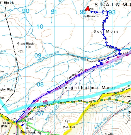
Relevant - red arrow route to Harter and blue arrow route to Romaldkirk - ignore other marks


Wednesday 28 August 2019

Addendum to previous post (parliamentary democracy)


At the time of the referendum I was a remainer and still am. The difference is that as a serial fence-sitter I was prepared to accept that others thought otherwise and so be it - that is part of democracy- now I think I would have to consider my relationship with much more antipathy towards anybody who supports this alarming dismemberment of democracy because it has gone from an economic debate to something that reeks of dictatorship. chicanery, and threatens the whole well being of our country and the foundations of our system, which while not perfect, is respected as the basis of democratic governments worldwide.

Trig points OS Sheet 91

Monday 26th August 2019
Harter Fell              NY 928 327 - 481m.
Romaldkirk Moor  NY 956 217 - 410m.

I had just got as far as the headings above when I had a quick look at BBC News to see the appalling report of Johnson shutting down Parliament. As I write I feel literally physically sick, my stomach is churning. I can't believe that this is the will of the people whether they want to leave or remain - are we prepared to finish with democracy and accept direction from an unelected prime minister who is acting in many respects as a dictator? It is difficult to comprehend that this is happening in our country.

Shades of the 1930s in another country.

I just have no motivation to continue with this post at the moment. What else can one do? I have written to our MP.

I have just found there is a petition to sign:

   Click here.  269157

Friday 23 August 2019

Conder Green and Glasson

22nd August 2019 - Thursday walk with Pete


Having now walked this cycleway from Caton and through Lancaster we felt obliged to backtrack from Conder Green to our last finishing point which was not accessible by car. It remains to be seen how far we can pursue this project.

During my boat building period I was keen to build one of the smaller Wharram catamarans. James Wharram is a designer of catamarans which have become a kind of cult surrounding theories about Polynesian sailing achievements and the like - he is still batting at 91 - see Wikipedia:

click for link

Wharram sells the plans for home build using simple plywood and epoxy methods well within the abilities of the relatively inexperienced for the smaller versions. Where we parked at Conder Green a large Wharram was sitting there on the grass looking dilapidated and forlorn. I wonder how they get these boats into navigable water from these estuarine locations - the river Conder flows past here but it would not be easy to get this big boat down to the sea proper.

We trekked the one kilometre to our previous finishing point then returned and carried on south over the River Conder bridge from where we watched a lady with a couple of dogs having great fun in the fast flowing water below.

There was another decent sized two masted yacht stranded at a crazy angle with its twin bilge keels embedded in the mud on banking high above the small channel below. We thought it may have drifted there by accident - it didn't look like a mooring where a responsible owner would have wanted to leave it.

Our time limit was up as we arrived at the outskirts of Glasson Dock village, but we were alongside a road with a convenient carpark opposite for our resumption of the next section.

Close to the aforementioned Wharram I noticed a memorial plaque to Christine Ann Dawson but Internet searching revealed nothing despite this being a more prominent and larger memorial than usual - one wonders.


We have had two Springers in the family - what a happy and fun loving breed always ready for action and especially with water and MUD!

Would you have left your boat like this?


Wednesday 21 August 2019

Trig Points OS Sheet 91 - Collinson's Hill

Tuesday 20th August 2019 Collinson's Hill - NY 922 104 - 434m.


"At the best of times, even in sunshine this crossing of Sleightholme Moor is like walking in porridge. After heavy rain it is like walking in oxtail soup. In mist, although after the first mile one cannot go far wrong with Coal Gill Sike and Frumming Beck as guides, it is a journey of despair."

Alfred Wainwright, Pennine Way Companion


So says he. As was his perverse wont Alfred walked the Pennine Way from north to south. My route today from Tan Hill Inn went south to north which is the direction most people take as did I in 1987.

Collinson's Hill is only one and a half kilometres south of the A66 but with the need to involve farms, which are not easy to access from the dual carriageway of the A66, that was not an attractive proposition to me. Much better to have some nostalgia re-walking more of the Pennine Way from the south.

As I left the Tan Hill Inn I noticed a gritstone outcrop tucked in behind the the pub but a brief Internet search revealed nothing.

Happily sections of the PW I have re-walked recently have not become fifty foot wide quagmires. Today I found a pleasantly defined path that any walker would welcome, albeit a bit marshy in places. I get the impression that this, the best of England's long distance paths, is not walked as frequently these days. My feelings were more of pleasure than the old curmudgeon's "despair" as I enjoyed the remote moorland country with the purple heather coming into bloom and a wide variety of grasses ranging through the complete palettes of greens, browns, and rusty yellows.

I  branched  off the PW on another plastic terrain track which took me to a Land Rover track leading eventually to within half a kilometre of my trig across medium rough moorland. At the junction of terrain and hardcore there was a jolly sign reading "Killer Butts" to greet the shooters as they would be dropped off to get to their "killing" stations.

Th LR track crossed White Stone Gill by a new substantial bridge where the OS map only says "ford." Following the track climbing up to higher moorland I passed a shooter's hut, then surprisingly a black painted wooden pigeon loft with two pigeons taking the fresh air on their little balcony. My cynical thoughts pondered on the shooter's motives for this incongruity, but my imagination failed, but it still left me with a bet that it was for some dubious purpose. As I plodded I saw several cartridge cases littered on the ground and many traps, all empty - I reckon all wildlife excepting grouse has long since been exterminated.

From Collinson's Hill trig I could see the line of the A66 nearly two kilometres away with a non-stop procession of traffic, the white vans standing out more clearly than others.

On the way back I found what coarse fishermen call a "a good hole" beneath some board walk and munched my Stilton and tomato sandwich and swigged coffee from my flask. A mixed party of four walkers were incoming from the south. They stopped and I was informed they were doing the middle section of the PW only - they hailed from Israel and said I was the first walker they had seen on the trail for two days supporting my suggestion that the PW is now less frequently walked.


Tan Hill Inn - gritstone outcrop behind caravans - also see next photo


Back to THI. The white blobs are bell tents - we used them when I was in the Scouts, rarer these days
Wainwright's version of despair but not so mine.
I could see the A66 just below the skyline about six kilometres away


Apparently little used sheepfold

Somebody knew what they were doing

Death Row?

The Land Rover track went up past the shooter's hut with the enigmatic pigeon loft a bit further on


Modern grouse butt

White vans on A66 just visible on background of trees in the centre


Friday 16 August 2019

Lancaster Cycleway continued

Thursday 15th August 2019 - Walk with Pete - Aldcliffe to Ashton Hall


We have followed the cycleway in sections from Caton in the north now down to Ashton Hall well south of Lancaster and it is beginning to look impressive on the map, especially for eighty-five year old Pete.

Today and the previous section included long stretches of tarmac following an unerringly straight line converging to a vanishing point in the distance. That sort of thing can be dispiriting, but today some views opened up of the now estuarine River Lune. On the other side we saw a huge area covered with solar panels - perhaps that's what farmers will do in the future with their land to counter the proposals for excluding red meat from our diets?

The area is populated with a network of electricity Pylons sourcing from the nearby Heysham power station. In particular two majestic giant pylons carry the cables nearly half a kilometre across the estuary - I have seen their relations doing the same further south crossing the Wyre. I quite like pylons in moderation - I imagine them as human like thus detracting from their static stance and appearing more to be on the move taking massive enviable strides regardless of the nature of the terrain they are ghosting over and hurrying with diminishing perspective into the distance.

There were many more family groups of cyclists and walkers and we were often having to dodge out of the way, but most were friendly. We are at the peak of school holidays.

We walk one hour each way which gives us roughly a four mile trip but Pete likens himself to a horse sensing water (in this case tea and cakes at Café Ambio) and we tend to walk faster on the way back - today we covered our two miles out in exactly one hour, but the return journey was five minutes faster.

When we arrive at the turning point we survey for car parking for our next start. Our two miles finished at an old bridge across the path leading from Ashton Hall which sports a café and golf club, the café of course having public access from the main road. At the bridge a well used mud bank went up the side to arrive onto the track over the bridge leading back to Ashton Hall but there was a notice saying "No unauthorised entry." We will have a look from the café car park next time to see if we can walk down that track - if not we will park in Condor Green and walk the short stretch back to today's finishing point under the bridge, then turn and head south again.

A gap in the hedge giving us one of our occasional views of the now wide River Lune. Note the pylons.

In my imagination the mother and father for the smaller pylons on either side of the estuary

Heysham power station (full zoom). Seen in many other photos on my walks from much greater distances


Only blue north to south track relevant to this walk. My Memory Map is scattered with all sorts of routes and such like 

Again, only the central blue track is relevant showing the whole of the cycleway we have walked to date

Tuesday 13 August 2019

Trig Points OS Sheet 103 (1)

Monday 12th August 2019

Whelp Stone Crag - SD 759 591 - 371m.

THE GLORIOUS TWELFTH? Perhaps my worst walk ever?

I can't allow qualification for the absolute worst - I would have to think about that, but today not the worst because the prime objective was a little gem.

Nearing completion of OS Sheet 91 trigs I have now identified those on 103 -  this is the first. I had to visit the dentist in Kirkby Lonsdale and this little crag has been on my to do list for a few years.

I set off walking at 11:20 having plotted a circular walk taking in what looked like pleasant footpaths following  Bottoms Beck back towards its source.

The footpath from Whelp Stone Lodge was hardly visible and over moderately rough ground, but it was only a short distance to the splendid summit and trig of Whelp Stone Crag - the last high point (with both meanings) of the day. In particular there is a  panoramic view taking in all the Yorkshire Three Peaks (Ingleborough, Whernside and Pen-y-Ghent) when one so often only sees one or two.

The descent, after thrashing through a field of tall reeds, took me into Gisburn Forest.  Here I met three mountain bikers mending a chain. GPS told me the well made footpath was my intended one and happy to be on such a good surface I marched on for quarter of an hour. Then looking at the map and GPS I found I was in the middle of nowhere. It seems Gisburn Forest has been laced with purpose made mountain bike tracks with deliberate snaky bends and banking on the outer edges. As this was dawning on me a couple of mountain bikers came flying towards me and it was difficult to get out of the way and I realised I shouldn't really be there, after all one wouldn't walk round Brands Hatch when the racing was on. I had no idea where the track was leading but had no alternative but to press on.

I was beyond the point of no return.

I emerged on a proper forest road about a kilometre from the path I should have been on which arrives at Hindley Head (see map) so by now I was frustrated and in for a longer walk than planned.

At Hindley Head I passed some guys unloading a monster tree felling machine and then missed a footpath turning to the left walking on a few hundred yards before returning - the footpath departure was not obvious from the forest road. After another check ten minutes in I found I was again off the path marked on my map and spent another twenty minutes backtracking to find again anther non-obvious path branching off. After two hundred yards the whole forest was blocked by trees fallen in all directions.

I was becoming irritated and then telling myself to be resourceful and to rise to meet the challenge, something I have previously itemised as part of the "enjoyment."

Perilously I descended a very steep banking clinging onto and climbing over fallen trees to arrive at a stream. I followed this through waist high vegetation with indecision about which side of a wall to be on and more backtracking to eventually arrive at the path shown on the map skirting the edge of the forest. After three hundred yards this substantial track, not marked on the map, veered off east into the forest. My path, as marked was non-exsistent despite GPS telling me I was exactly on it. This absence of path on the ground continued for most of the rest of this walk and despite wandering back and forth and identifying my supposed location on the path with GPS I never found it. I was following Bottoms Beck but on a steep hillside of waist high reeds,  huge tussocky grass and the stumps and branches of long ago felled trees half hidden in this melange of  almost un-walkable terrain. Because the OS marked path was higher up the hillside I kept ascending steeply to try and find it and then descending again because lower down the terrain was marginally less formidable. There was nearly two kilometres of this stuff and my speed over the ground was hardly measurable, and distance more than apparent looking at the map..

Back home I measured as best I could the route I thought I had followed - 7.09 miles and 6.5 hours (including about ten minutes sandwich break) equals 1.09 MPH.

Near Fair Hill (marked on the map) I picked up a forest road and then a path leading me back over Whelp Stone Crag, and now weary and disillusioned, and much later in the day than I had intended I managed to take the path leading to Brayshaw rather than Whelp Stone Lodge adding a bit more to this unenjoyable walk. Without the gem of Whelp Stone Crag itself I would certainly put this in a list of say the ten worst walks ever.

Whelp Stone Lodge - starting point

From Whelp Stone Lodge to trig then zig zag south and clockwise. The awful part was from Hindley Head  to furthest north. The zig zags are just a representation of the mountain bike track I inadvertently followed instead of the OS marked path leading more directly to Hindley Head

First view of Whelp Stone Crag. I diverted to investigate outcrop right of centre - it was not very interesting, thren I climbed onto and followed the ridge to the trig


The Yorkshire Three Peaks on the horizon

Back to Whelp Stone Crag just before I entered the forest


Tree fellers just arrived. Just beyond here I missed the path off to the left walking on, and then backtracking

Just beyond here I walked past the branching off of my path and had to backtrack. After a short distance the whole forest ended in randomly fallen trees necessitating a perilous descent and then a bushwhacking detour. Not long after this I reckon I lost the will to live and photos took a back seat


********************************************


Football

Just another little rant at the anti-role-model aspect of what should be a fine sport to watch.

From an ITV pundit/commentator the other evening:

Referring to a penalty awarded against a player who blatantly pushed another over with both hands, "A clumsy challenge"  inferring that if the offender had been more skillful he would have got away with an obnoxious foul. I find it particularly objectionable when the commentators themselves are drawn into this adulation of clever fouling.

Wednesday 7 August 2019

Trig Points OS Sheet 91

Wednesday 7th August 2019

Culgaith -                NY 601 301. 152m.
Low Abbey -           NY 652 275. 187m.
Broad Lea               NY 660 234 155m.
Fouson' Rigg           NY 651 189. 210m.
Town Head (near)   NY 606 220  17nm.

This campaign has been badly organised by me. It started in 2009 and carried over into 2010 and was then abandoned until its recommencement in recent months. The two earlier sessions were partly done on my own and partly during a caravan trip to Appleby with Pete. On that trip I didn't keep good records and it has taken me a lot of faffing and detective work but I am now confident I have visited all the trigs barring five still to do. Two of those are on the Army Warcop firing range which will need special attention, and the other three will be done in two visits. The total number is 49.

Today was a pleasant contrast from yesterday's deluge and all was well -  little excursions from the car,  easy parking, and  a grand tour of pretty red sandstone villages.  The remaining three (excluding Warcop) will be a bit more strenuous. I am pretty sure that all today's actual trig locations were on private land and I never saw anybody to ask permission.

Worth clicking first photo to view all as slideshow

Culgaith. Taken from the road. The trig is about thirty yards down the righthand hedge line,
see next photo

Culgaith

Low Abbey 1. Setting off from the road

Low Abbey 2. There was a welcome at the start of this huge wheat field

Low Abbey 3. What's that coming over the hill?

Low Abbey 4. And a cheerio at the end - what a view

Low Abbey 5. Mysterious metal bars attached to the trig. Could they have been used for lifting it - but why?

Low Abbey 6. The trig in context - the northern Pennines in background

Broad Lea. I had to walk a long way up the bridleway beyond the striking off point to find somewhere to climb a barbed wire fence. I found a corner with a helpful tree alongside. The map below shows my wanderings. No expensive gear was ripped and wire cutters were not used 

Broad Lea

Fouson's Rigg. Well camouflaged 

Town Head 1. Chapel Bridge over River Lyvennet on the way to the trig

Town Head. A pleasant walk to get there but disappointing views...

...which lead me to try a bit of experimenting

Culgaith - Through a gate and thirty yards from road

Low Abbey - wobbly blue line shows my route

Broad Lea. Note I walked beyond the fence line leading direct to the ttig so I could find an easier way over the barbed wire

Fouson's Rigg. Blue line shows my route

Town Head. Blue line route starts from road at righthand edge of map

All in general context - bottom left corner one was done yesterday. Ignore green and purple routes - they are just part of a jumble of marks and routes all over my Memory Map. The vertical blue line is the western limit of this OS sheet 91 that I am involved with