For newcomers

At the bottom of each post there is the word "comments". If you click on it you will see comments made by followers, and if you follow the instructions you may also comment and I always welcome that. I have found many people overlook this part of the blog which is often more interesting than the original post!

My blog nick-name is SIR HUGH. I'm not from the aristocracy - my middle name is Hugh which relates to the list of 282 hills in Scotland compiled by Sir Hugh Munro in 1891. I climbed my last one (Sgurr Mor) on 28th June 2009

****************************

Saturday 22 July 2023

Mabel

 Saturday 22nd July 2023

On Thursday, 20th July, along with Pete and Elizabeth Mansbridge we attended the funeral of Mabel Lomas. There may be one or two readers here who knew Malcolm (Sol) Lomas and others from our assemblage of climbers and Yorkshire Mountaineering Club members from the West Riding area back in the late 50s and early 60s. There were over a hundred people at the funeral with a luxury reception back at Cleckheaton Golf Club.

Those early days were good times and then people became married and had families and we more or less drifted apart except for one or two connections that continued over the years.

My walking friend Pete who now lives in Arnside was amongst the aforementioned group and his lifelong pal going back before both of them did National Service was Malcolm (Sol) Lomas and we have all kept in touch periodically over the years. Going back ten years or more when I was closing in on the completion of the Munros I went on several Yorkshire Mountaineering Club Easter meets in Scotland and climbed a number of Munros with Sol. We stayed on caravan sites for those meets and Sol's wife Mabel was a damn good cook and would send tempting dishes of food across to my caravan. All happy memories of a kind friend.

*****************************************************

With Pete and Liz I drove down the A65 to attend the funeral at Elland Crematorium in preference to the shorter in time motorway routes.

On our return journey we had to negotiate the most complex roundabout system I think  I have ever come across at Gildersome.


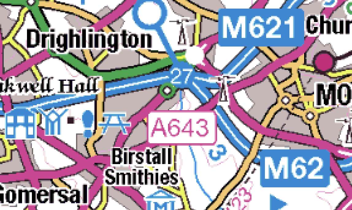
Courtesy of Google Earth


Saturday 15 July 2023

Witherslack circular, 14th July 23

 Friday 14th July 2023

Just trying to find some unwalked paths not far from home.

This little excursion took me unexpectedly up the side of a previously unseen limestone quarry on a scree path: the sort of thing I keep telling myself I should avoid  these days. I huffed and puffed until the scree path joined a better but still steep path through old woodland with an air of mystery.

After levelling out for a while a gate lead onto open level ground, a summit plateau giving easy walking on cropped turf. Sheep  normally run off as though they expect immediate harm from any passer by, but more irritating is their inborn tendency to being herded so they just follow on in front of you instead of moving off to one side to let you pass. But the sheep were  here were strangely tame and one even came to sniff my hand as would do a friendly dog. 

At my furthest north I had a glimpse through the trees of Witherslack Hall School where my daughter used to "try" to teach delinquent kids found uncontrollable in conventional schools and boarded out to this old mansion.

This is not a particularly old building but it has a commanding presence nestling under the steep limestone slopes of Whitbarrow Scar, a venue I have eulogised about here and visited often.

From the link below I gleaned the skimpy bit of history shown below the link, there is little more information on that site for those who may be interested.


Witherslack Hall is home to a large private school having previously been the family home of the Earl of Derby. It dates back to 1874 and has been the home of the school since Word War II.

A winding and attractive path lead through more old woodland back to the road and a short trod back to the car. That was  satisfying to find so much perviously unvisited within a three mile walk close to home. 
PLEASE CLICK PHOTOS TO ENLARGE


The scree path can be seen leading off steeply from the foot of the quarry. The path zig-zags to come out on the plateau of the 
skyline

Much steeper than it looks. Why do photos always disguise steepness?


Out onto the open plateau and the friendly sheep


Lawns House


Witherslack Hall School below the slopes of Whitbarrow Scar

Start finish at the 22 spot height


Sunday 9 July 2023

Unfinished business

 Saturday 8th July 2023

My last post raised a question.

When I am walking and see something off the route I have an innate compulsion to explore and find out more. I also lookout for things to research on the Internet when I get back home. I have noticed many people do not seem to have that kind of curiosity and they can even transmit a disguised minor irritation when I  delay our progress as I poke about to look at the map to find where an inviting looking footpath goes, or examine some other oddity,  or maybe to get a better view of what might be a secret climbing crag. I recognise that irritation when my companion lingers on the spot to wait as I trog off to examine rather than joining me to have a look.

 NOT SO Bowland Climber.

On the aforementioned previous walk with BC we looked across the River Kent from the A590 underpass to see a track coming down to the river from above and branching along the river bank in both directions all looking well maintained, but we couldn't see how far it extended in either direction. The map showed nothing, not even an access point from the road above. 

We both agreed this this must be explored and so that was my mission today.

I had nor gone more than a hundred yards from the car when I was already stopping to look at the map to find the destination of an inviting footpath leading off from an ornate pillar and gate. Further on I came to a barricaded gateway barring the way into a compound I could not see. Signs indicated a connection with the Environment Agency, but obviously not the access for our mystery footpath.

Further on I found a barbed wire protected and padlocked gate with private notices which revealed the path had been provided for river access by an angling organisation. I was not able to find any more about the unusual use of the term "waste fishery" on the Internet. I walked a bit further to where my minor road crosses over the A590 then returned and followed our previous route back to the A 590 underpass. BC had since found out that the limestone wall there was used by local climbers for bouldering. Neither of us had noticed evidence of this and I had a close look and found the unmistakable chalk marks and then a series of red painted dots picking out the line of a long traverse.

I continued on minor roads to make a three mile round trip with two more items of interest.  After risking my life crossing the dual carriageway of the A 590 I found a modest, faded, wooden sign pointing down a track to Cath's Plants. That would not normally be particularly interesting but it had the addition RHS Chelsea Gold Medal Winner. My walking friend Pete's wife Elizabeth was a primary school head mistress, but she could easily have had a career as a plantswoman with her profound knowledge of the rarer cultivated woodland plants and shrubs and their garden is a delight of natural planting. Cath's Plants looked as though they may cater for something more out of the ordinary and I was able to find a website and pass the  link on to Elizabeth in case she was not aware of this apparently hidden source on our doorstep.

A few other footpaths branching off my minor roads were noted for future exploration and then I found an extensive limestone quarry almost hidden from the road which I must have driven past at some time and not noticed, but a couple of hundred yards up a track from the road had me at its base. It was quite overgrown and loose looking, and then tiered  and would not offer much for climbing despite its wide expanse and impressive height of a hundred feet or so.

Quite a rewarding little three mile round trip.

CLICK PHOTOS TO ENLARGE, especially the panorama

Where does this one lead to?


I do not always take heed of private path notices but this lot was enough to put me off

Unmistakable chalk marks, and below, red dots leading off on a long traverse


The fishery path coming down from the road. Below, panorama of its extent


Tuesday 4 July 2023

Taking time out

 Monday 3rd. July 2023

During my walk with Bowland Climber described in my last post here  our wide ranging conversation at one point reminded me of a poem/verse/words, call it what you will, that I wrote some time ago and I thought to dig it out back home. I then decided to re-write it and here it is:


Media news conspires to depress,

Global warming, species extinction, famine. and war.

There are some who care and I donate,

But my conscience is not assuaged. 


Maybe I need some space, temporary denial?

An artist follows News at Ten

She carries a friendly camera through limestone sublime.

No music, just footsteps crunching... and birdsong,

And the varying shush of the wind.


Occasional words with passers-by

And sparingly and gently our artist's artist's thoughts,

And in between, silence…

Silence almost whispers as we value time,

And reflect on pastures green, and wide blue skies

And a river rumbling, then slowing,

To a pool of good brown ale

With clarity letting us see down down deep.

Sunday 2 July 2023

Levens with Bowland Climber

 Saturday 1st July - North from Levens

A combination of many circumstances have prevented a walk with Bowland Climber for a long time. We maintain regular contact with mutual blog comments, emails, phone conversations and visits. At last circumstances have aligned to allow a get together again for a walk. 

Although I can do six miles with relative ease I have to take the slightest gradients slowly and BC being aware of this, and considerate, had found an almost gradient free route only fifteen minutes drive from my home. I have done most of this popular walk but many years ago.

At Levens a slip road shortcut connects the A590 with the old A6 with an extensive lay-by facility  used by car sharers  and walkers. My daughter and I have used this on occasions when Daughter could not take granddaughter Katie to school at Barrow and I would rendezvous with one of her colleagues who lives in Kendal to drop off and pick up Katie.

A large part of this walk goes through the parkland of the Levens Hall estate. Our well founded track follows high above the River Kent and is lined with massive beech trees which must be hundreds of years old. There is also a herd of rare Bagot goats roaming; we did see some but too far away for a photo. At one point BC disappeared until I saw him across the grassland attempting to get the whole of one of the giant beech trees into photo frame.

The river far below follows a twisting course with alternating seductive pools and then fast running water. I have walked the whole of this river wherever that is possible right back into upper Kentmere to Kentmere Reservoir and beyond to its source;  a part of the Lake District with many memories. We walked as far as Natland then headed back closer to the eastern banks of the River Kent on a path not familiar to me with sightings of the river with long dark pools of that brown but crystal clear water like good bitter beer inviting one for a swim.

We found a bench overlooking one such stretch of the river for sandwiches and coffee.  We had only just seated ourselves when a couple with dog appeared and we wondered if they had been anticipating the use of this well placed seat only to find it occupied,  an occurrence I have suffered from myself on many occasions.

Near Low Sizer we had crossed the river again by a well engineered suspension bridge with a warning notice restricting people to a maximum of twenty five. It did sway as we crossed and I wouldn't much like to have been on it with more people, and much less so with the permitted twenty five

A short stretch of tarmac walking took us to a cul-de-sac offshoot where the continuation  encountered the A590 with an ingeniously constructed underpass, a part of the walk that was definitely new to me and again giving more rewarding views of the Kent river. Once on the other side of the A 590 a wide close cropped footpath back though the Leven parkland  had us back to Levens and our car. A most enjoyable six miles in good company.


Looking up the River Kent from close to our car parking - we entered the parkland from this bridge.

Huge beech trees. How many people to link up all the way round?

BC disappeared to get a good photo of the trees

Enticing glimpses of the varied river far below

There is a badly eroded bench mark on the middle keystone, see below. Note here we were following the upper reaches of the Lancaster Canal now drained. It terminates in Kendal. I have previously walked its whole length as recorded in numerous posts on this blog

The bench mark even now difficult to see but more apparent in real life

Sedgwick Hall, Now converted into apartments

Skew bridge/aqueduct carrying the canal (now drained at this stage) The skew bridge is a masterpiece of stonework engineering

Perhaps a feisty sheep longed to get into the next field only to find its efforts thwarted by continuation of the ironwork on the other side?

This swallow (I think) was being fed periodically by its parent as it sat waiting. Attempts to get the feeding action on photo failed. This shot was taken on full zoom then enlarged again snd cropped in Photoshop Elements so detail not bad considering


Our lunch bench was higher up this slope

Twenty five maximum people only permitted. It swayed enough with just BC and myself

Preparing to go under the A590