
Sunday 16th January 2022
Swallow Scars SD748 518 283m
Woodhouse Gate SD 712 540 199m
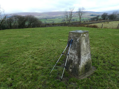
Burn Fell SD 673 535 431m
At last a walk since before Christmas.
'Twas not much fun setting off in the dark at just turned 7:00am. But eventually there was enough light to appreciate one of the most spectacular roads in England which wends its way over the fells to descend to the source of the River Hodder through wild steep hills and moorland with the road twisting, turning, descending, and with blind summits every so often, and sheep wandering and the final steep descent into Slaidburn.
Swallow Scars was about four kilometres east of Slaidburn. With the car parked in a marginal lay-by it was over a stile twenty yards up the road and half a mile of rough swampy moorland and then a left turn to climb on drier ground to the trig now visible on the skyline - forty minutes there and back and then a drive to the west and north of Slaidburn for the next two trigs.
For Woodhouse Gate I was able to park at the entrance to a service road leading to some complex to do with the waterworks of Stocks Reservoir I think. A climb over a locked gate and a couple of hundred yards over a field brought me to a barbed wire fence with my trig only about twenty yards beyond. At first I thought I would have to settle for that. I then noticed a place where a barbed wire support post was leaning away from the normal wire fence with the post at an angle of about 30 degrees from the ground. I was able to crawl through to get in between the barbed and the normal fence wires and then stride over. I was well pleased with that achievement.
The start for Burn Fell was only a few hundred yards drive further up the road. I had researched for parking via Google Earth which showed a wide entrance to a cattle gridded farm road. When I arrived I was not too happy about the possible positioning of my car but then a dog walker appeared and asked if I was lost. She turned out to be the farmer's wife and pleasantly gave me permission to park indicating the appropriate positioning. I could have driven back the few hundred yards to the spot for Woodhouse Gate but this was better and by the time I got back to my car four hours later I was glad I hadn't any further to walk.
Pleasant downhill on the farm road took me through the farm and then onto a short stretch of uphill field and descent to arrive at the cul-de-sac road continuing for miles as Salter Fell bridleway over the tops and down into the Lune valley. The climb up the road was long and steep and I was feeling the strain after my long lay off from walking.
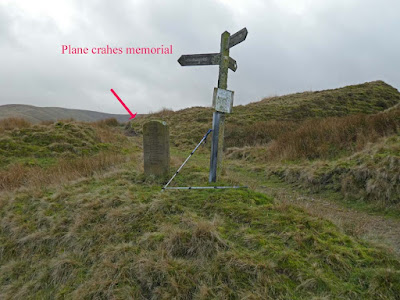
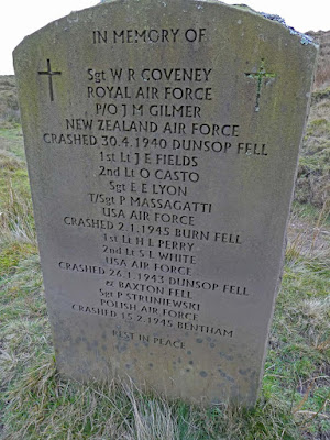
At the end of the tarmac a poignant stone memorial under a wooden finger post tells of various RAF planes that crashed on the adjacent hills during WW2. My path branched west leaving the Salter Fell bridleway. I climbed and climbed following a trough like path with a marginal stream and stones and I alternated between the stony trough bottom and the more pleasant grassy banks on the edge above. At the wall boundary of Dunsop Head I turned south to climb up to my trig. This had been a long relentless ascent. Memory Map tells me the total ascent for the day was 961 ft. Not quite comparable with Munroing, but enough for me these days.
The descent was much quicker. Halfway back down the cul-de-sac tarmac I suffered incredibly painful cramp in my inner left thigh. After various stretching and attempts to relieve I managed to walk on only to get a similar occurrence in my right thigh. The pain was intense but I found the best relief was to continue walking and to stretch that leg as far forwards a I could with each step and after a few minutes I was free of pain. The surroundings up on Burn Fell had seemed incredibly remote and wild as I sat there in my folding chair munching my sandwich and supping my coffee.
I now have only three more of these 76 trigs left to do. Two are in the Trough of Bowland to be done together. The final trig is at Crookrise Crag, a rock climbing climbing venue of old, and I have promised to do this, as and when, as a nostalgia trip with Bowland Climber.
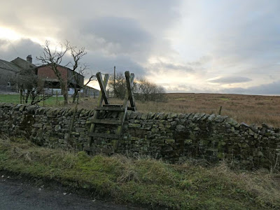 |
Twenty yards from the car - the path through swampy moorland to Swallow Scars trig. It twas about 9:00am, the light is still struggling |
 |
| Left turn here from where I could now see the trig (see next photo) |
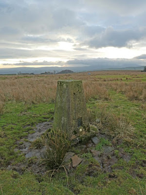 |
| Swallow Scars trig west and... |
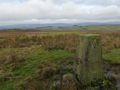 |
| ...east |
 |
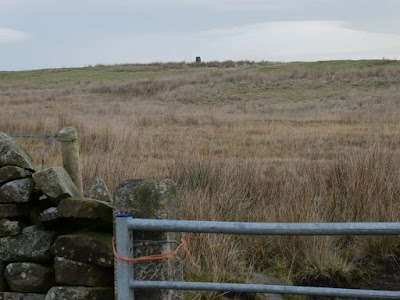
| Woodhouse Gate. A farm was visible down below and I was on private land having engineered the conquest of a barbed wire fence so I was off smartly before I may be spotted |
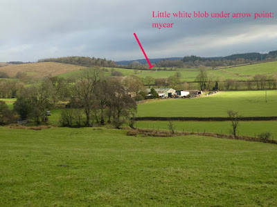 |
| View from the start of the road leading to Salter Fell road. My car in the distance |
 |
| My Dunsop Head path leading off from the Salter Fell track |
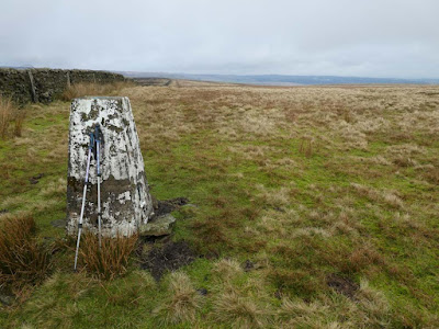 |
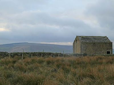
| Burn fell trig looking east |
 |


A long day on rough ground.
ReplyDeleteI was impressed that you walked all the way from the Slaidburn Road through Shay House Farm rather than parking at the top of the lane near the war memorial. Apart from the farmer's wife, did you see anybody?
I'm hardening my heel ready for Crookrise.
BC - I was aware of that possibility but wanted to have a decent walk and my start was conveniently close to the previous trig. I saw one other couple chopping wood in a field. They had two very friendly collies that came racing towards me and leaping up from the muddy terrain, but in friendly fashion. On the summit of the last one I saw another couple passing in the distance. Walking up the road you mention I was passed by two motor cyclists who carried on over Salter Fell as well as another couple just cycling who disappeared in the same direction. You've jogged my memory for items I should have included, also I forgot to do the map. I will add it now.
ReplyDeleteWell done Conrad, good to see you out and about again, though I do still enjoy your modeling postings.
ReplyDeletePhreerunner - Yes. It was boost to my well being, a long time coming. There will be more on the Ducati's intricacies shortly.
ReplyDeleteYou'd have reckoned that some of those later pilots would have learned the lesson.
ReplyDeleteRR - You set me wondering about how RAF crew navigated during WW2 and I came across this reminiscence from a Lancaster navigator:
ReplyDeletehttps://www.forces-war-records.co.uk/blog/2014/10/16/life-as-a-navigator-in-raf-bomber-command-in-world-war-two
How those guys performed such complicated calculations whilst straining to look at the lie of the land below in the dark whilst mayhem prevailed all around is beyond comprehension. As this navigator tells us their calculations were based on met reports that could be woefully inadequate and inputting a given wind speed that was only slightly incorrect could have one miles off track. It is not surprising that many succumbed on our Pennine Hills.
The mortality statistics and comparisons quoted are chilling.
During my RAF national service, my trade was that of Air Wireless Fitter. This meant I was trained to test and repair electronic communications equipment carried by planes. A few extra bits of kit - radio altimeter, hand-generated dinghy emergency transmitter/receiver - were also thrown in.
ReplyDeleteRichard, who had prior Civvy Street electronic experience, was a step above me as an Air Radar Fitter - much more complicated kit. Notably H2S, 24 separate black boxes which combined to create a dynamic if somewhat crude "map" of what the ground looked like immediately below the plane in flight, and Gee, a system which used intersecting radio signals (transmitted from the UK) which could be read off to give an exact position of the plane over enemy territory.
Part of my training included scrambling through the guts of a Lancaster bomber to find where the communications kit (primarily a VHS transmitter/receiver and the all-frequency transmitter/receiver you encountered in one of your models) were located. En route I noted the H2S boxes and was thankful I wasn't responsible for their complexities.
Obviously H2S and Gee were important navigation aids but I wondered if they were introduced when the war was almost won. Not so; they became operational as early as 1942 and must have been a blessing to RAF crews who flew to destinations which were a long way from home, eg, Munich.
To give the crews mentioned on the memorial their due, it's unlikely any of them were flying Lancasters and thus able take advantage of the advanced radar I have mentioned.
RR - That's interesting. I didn't realise they had that more sophisticated stuff so early on. I never heard you talk about crawling about inside Lancasters before - I'm quite envious, but I suspect the downside of National Service outweighed the value of that experience, although you have been able to use the overall experience in your writings in later days.
ReplyDelete