Friday 4th July 2025
This walk starts from Thwaite Bridge, about three kilometers east on the A 684 from The Moorcock Inn. Just beyond Thwaite Bridge there is a large lay-by for parking.
The nine mile drive from Sedbergh down Garsdale to the Moorcock Inn must be one of the longest most twisty roads in Britain. Fortunately it is not single track, but still worryingly narrow. The scenery is dramatic in this steep sided archetypal Dales valley and despite the drama of the road it is always an enjoyable experience enhanced by the knowledge that it is the gateway to the still largely unspoilt Yorkshire Dales.
From the lay-by a fifty yard walk back up the A 684 gives access to the old Thwaite Bridge to cross the River Ure. Straight ahead is a not very obvious path leaving the tarmac into a dark and steep brief ascent through woods. The path then opens out onto upland sheep pasture with tussocks and reeds and, for me relatively, a steep huffing and puffing frequent rests ascent gains what is named as The High Way on the 1:25 OS map. This high level ancient bridleway starts from further east on the A684 from my own start and continues to eventually join the Kirkby Stephen Road with Wild Boar Fell looming up on the other side of that road. This track is included in various long distance walks including Lady Anne's Way. I have previously walked on the section opposite Wild Boar Fell past the Water Cut sculpture.
The views from this track are stunning with a complex of steep sided dales and wild hills in all directions, most of which I have memories of visiting over the years, but others that have been missed and are firing the imagination for exploration.
Most of the way there is a broad grassy path following a wall on my left which on and off shelters me a little from the strong wind that persisted throughout the walk. I keep having to tighten the chin strap on my Tilley hat to stop it turning into an unleashed kite. Every now and then I would peek over the wall and look very steeply down to the river Ure and the A 684 high on the opposite side of the valley. There were a couple of occasions when RAF jets heart stoppingly flew through below my level.
Yet another long distance path, The Pennine Bridleway, branched off to the left to descend to the Moorcock Inn. Where that path crossed the River Ure at Ure Force Rigg there was an attractive mini waterfall and another footpath leading off east to take me back over undulating sheep pastures to Thwaite Bridge. As I was approaching that waterfall I noticed a female walker about fifty yards behind me. I stopped to take a photo and thought she would catch me up, but she also stopped. I guess she thought I may be some kind of predator. It's such a shame that female walkers should feel so threatened. As I went off on my path left she had continued on the path back to the Moorcock.
At Yore House marked on the map I was able to sit on a vehicle trailer for my sandwich and coffee break. This old farm with several buildings was in the process of renovation but had a sort of Marie Celeste atmosphere of dsertion. Tools and equipment had been abandoned looking as though there had been no attempt to tidy before some unexprected urgent departure. Everything about the work being done looked shambolic and disorganised. I'm glad I was not employing the builders involved. I often come across similar rernovations in remote locations all over our countryside where no work is taking place and little evidence of it having been done so recently. Perhaps folk just run out of money, or contractors go bust or walk off after finding the job is more demanding than expected.
I got back to the car at a 3:00 pm. Rain had been forecast for later in the afternoon and it came with a vengeance on the way home, which made me smile a little with some smugness, and I applauded the fairly consistent accuracy of our forecasts these days. It had been a great pleasure to be high up again in the Yorkshire Dales, the best walking area in England in my opinion.
 |
| Thwaite Bridge |
 |
| Sleep ascent from here all the way to The High Way |
 |
| Out onto the fell side, and below |
 |
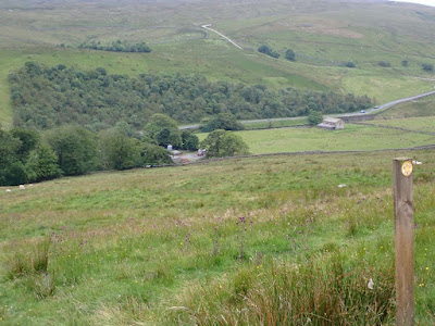
| Looking back up the A684 towards the Moorcock Inn |
 |
| Back down to Thwaite Bridge before gaining The High Way |
 |
| Lime kiln in good condition. One wonders at all the activity that must have been afoot up here at an elevation of 1500ft. or so |
 |
| Just short of my high point on The High Way |
 |
| Looking back down to Thwaite Bridge from The High Way. Note the wall I followed up here sheltering me to some extent from the wild wind |
 |
| Wild Boar Fell |
 |
| Branching off for my descent on the Pennine Bridleway |
 |
| Ure Force Rigg |
 |
| Lunch stop. Yore House, woeful deserted restoration in the background |


Quite a remote area. That road from Sedburgh to Garsdale is in a time warp. Mark and I drove it many times getting to Wlid Boar Fell for the climbing we achieved over the last three years.
ReplyDeleteBC - Thanks for your comment. Without you and Martin and Alan R my blog has become almost without comments for the last year or so, and I'm wondering if it is worth continuing, but I do find it a good rference for my own use so I suppose I will battle on. There was always more response to my multi-day backpacking trips which seemed to be more appreciated than my short day walks.
ReplyDeleteI was thinking of your Wild Boar Fell climbing exploits as the distinctive outline was dominant in the distance for most of this walk, and I was respecting your sustained efforts to visit so many times. But the quality of the climbing, and the excitement of finding such extensive new rock certainly provided a compelling motive. It is surprising that such a venue lay undiscovered and the likelihood of finding anything like that again for anybody is remote.
I fully admit to being woefully lacking when it comes to making comments on the blogs that I read, but I do read everything you write - so I would certainly miss your blog if you stopped writing it.
DeleteThese days, I get far fewer comments on my blogs than you do, but I continue as it's a very useful online memory in place of the one that used to reside in my head.
I also find myself entirely surprised every now and again when I find that someone, who has never commented, reads what I write. I was chatting to someone I didn't really know (in that I knew their name but had never talked to them) a couple of months ago and was taken aback when they referred to something they'd read on my blog.
Keep blogging. Gives a good reason to do a certain walk sometimes. And as you say a good diary reference/
ReplyDeleteGayle - I do wonder if many have drifted over to the dreaded Facebook. I did join up years ago before I realised how puerile it generally is on top of which I just can't find my way round it.I absolutely refuse to get involved there except for perhaps four or five comments in the last five years when it was something I really wanted to get to a wider audience.
ReplyDeleteIn my experience, few people are using Facebook for blog-like purposes. Few of my friends ever post anything these days - Facebook seems to have become more use as a series of forums (in the form of Groups).
DeleteI think Vlogging on YouTube is the more popular choice for those who want to record their lives these days (but clearly, not so useful to be able to search for certain words/terms or to just skim an old post to see if something was as you remembered it).
Gayle - I think many You Tubers do so in the hope that their channel will go viral and make the, lots of money.
Delete