For newcomers

At the bottom of each post there is the word "comments". If you click on it you will see comments made by followers, and if you follow the instructions you may also comment and I always welcome that. I have found many people overlook this part of the blog which is often more interesting than the original post!

My blog nick-name is SIR HUGH. I'm not from the aristocracy - my middle name is Hugh which relates to the list of 282 hills in Scotland compiled by Sir Hugh Munro in 1891. I climbed my last one (Sgurr Mor) on 28th June 2009

****************************

Saturday, 5 January 2013

Mud and measurements


Bowland Climber’s last post, “Walk your paths...if you can”Bowland Climber  ) expressed concern at waterlogged footpaths, and discussed alternative road walking, and I sympathise, but...

...during the last foot-and-mouth outbreak, I found myself devising walks on minor roads, and tracks, which lead me to some interesting places I would not have otherwise visited.

On my Wales walk, (summer 2011), particularly down the eastern border, I tired of footpaths through cow trodden, soggy fields, or knee-high wet grass and brambles, and climbing rickety stiles, and unravelling navigation required for paths invisible on the ground, and often blocked off or diverted by farmers. I reckon that is a pursuit in its own right which is not one of my reasons for outdoor enjoyment. 

BC’s aims to keep our footpaths open, are noble, and I like to think I do my bit, but on the Welsh walk I eventually opted for minor road walking wherever that would fit within my self imposed intention to walk within two kilometres either side of the border. 

Yesterday, I was well aware of potentially gloopy paths, and planned a walk that was mostly on tracks or roads, but mud was still unavoidable.

I am no match for Mick and Gayle’s insatiable immersion in statistics   ( M and G go for walk ) but I have often wondered about the accuracy of different methods of measurement.

Yesterday I used a Memory Map 3500 GPS to record the trip. Back at home I measured the route using Memory Map on my computer, and used my own spreadsheet entering kilometres walked and time taken in hours and minutes. The spreadsheet converts kilometres to miles, and hours and minutes to decimal hours, enabling calculation of average speed in mph and km/hr, and minutes taken per kilometre walked. Minutes per kilometre is useful for estimating walking time to an objective taking advantage of the one kilometre squares on the OS map.

---------------------------------------------

Memory Map 3500 stats.

6.33 miles walked
2.09 mph

Memory Map on computer
and my own spreadsheet.

6.03 miles walked
1.93 mph

Make of that what you will.

I intend to record more of these stats to enable a more reliable comparison.

The start (SD 489 924) is at the car park, bottom of this map, about 3km west of Kendal. My route was anticlockwise
The car park is classic limestone pavement - it would be the envy of any motor manufacturer for use on their test track.


Cunswick Scar - perfect walking on cropped turf, even in current muddy conditions
Distant Kendal from the cairn on Cunswick Scar

Another for my "Signs" collection. I reckon it warns of a berserk runner who has gone round the bend?

Anyone for a bath?

This is a path I could have taken from Fell Gate to Capplerigg (see map), but avoided - here it emerges onto the road at Capplerigg

The strangely named Bonfire Hall. This is shown as an unfenced track on the OS map

My track emerges bottom right to water's edge. At first I though it would be a wading job, but then noticed the stone bridge, bottom left.

Saturday, 22 December 2012

Season's greetings


A couple of years ago I used a Google image of holly illustrating my post to send seasonal greetings to my followers.

Around the same time I wrote an informal review on the blog for Innovate Roclite boots.  The holly and the boots provide the most  frequent word related searches  in the part of Blog Stats, which as far as I understand, shows words or phrases people have used in searches  leading to posts on my blog.

The Roclite boots are long gone. They wore out after 27 days on my walk round the Welsh boundary.

Those boots and the holly still haunt me like Dickens's Ghost of Christmas Past.

I  wish all my readers and commenters the most sincere compliments of the season and best wishes for the New Year - I have much enjoyed all the communications, and also reading the blogs of many others where I have left comments and received replies - they will all know who they are.

Once again, best wishes to you all, and get stuck into that cake.


Wednesday, 19 December 2012

Three miles too far?


Years ago, from the M6 motorway, I spotted the mysterious  entrance to a valley just south of Tebay. Once seen, it was a must explore objective.

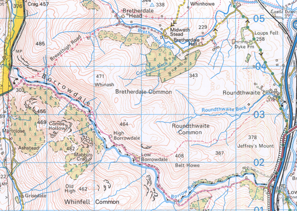
Borrowdale is the small secret cousin to the well known dale south of Keswick. A track, mostly unsurfaced winds up the valley for nearly  five miles from the M6, passing a remote farm halfway and continuing north-westwards to meet the old A6.

The River Borrow continues over the road for another two and a half miles to its source in the wild and rarely visited Shap Fells. I have walked and run the main valley and its northern and southern ridges on several occasions, and the whole area is pure delight. I have never followed the river on the other side of the road, although I have roamed the Shap Fells nearer the source of The Borrow.  A circuit following the river and returning via Bannisdale to the south looks inviting, although there is no continuous path marked on the map, and it could be rough going in parts.

In 2009 a planning application was submitted for a holiday/timeshare cabin village to be built in this dale which would have destroyed its rare solitude forever, but after strong objection permission was fortunately refused. 

Yesterday, in pursuance of flat walking, in consideration of my recovering knee, I walked from the A6 through to the M6 end and back, a distance just short of ten miles. That was further than I have walked since the op, and my inclusive speed was 2.8mph so the knee was painful by the end, and I was overwhelmingly tired that evening, but it had been a more than worthwhile trip re-acquainting myself with an all time favourite venue.


Just after the start looking down Borrowdale towards the M6 end

Looking back to the start. The straight line of the A6 is seen cutting across the centre of the background.
There is much criticism of windmills these days, but what about these three pylons of yesteryear? Click to enlarge for a clearer view of their intrusion on the landscape.

Looking back again towards the start. The peak in the centre is just on the other side of the A6 - High House Bank, 495m.

Low Borrowdale Farm - the halfway point. As far as I could see it was unoccupied, but the barn has had a new roof

The track crosses the stream and becomes Tarmac about half a mile from the minor road near the M6 which leads up to Tebay.

Another one for my "Relics" folder. The colour of the rust was almost surreal.


Friday, 14 December 2012

Two characters in search of an author *


Tuesday 11th December

Many walks have some emergent wannabe actor who doesn’t always get a mention. Today two seats played that role, but more of that shortly.

A call from T (we go back to schooldays) saw the scene set, walking up the River Kent from Burneside, following The Dalesway.

Burneside owes its thriving existence to James Cropper plc (paper manufacturing),  established 1845. The script here, and at Cowan Head, a mile upstream is complex. going back to 1750.   Click here for a history lesson

A mile beyond Cowan Head the second act took us back by paths and minor roads through Bowston, a bit player in the paper making history.

T has a science background, and inevitably an enquiring mind. Trudging down the road we passed a wayside seat, and thirty yards beyond T looked back and noticed it sported an unusual wooden barrier, and insisted we walk back and attempt to unravel the mystery - a play within a play? We concluded it wasn't the set for delivering the prologue, or preaching a sermon, more likely for safety, in consideration of the slope in front of the seat, but we agreed we had not seen anything similar before.

Our dialogue about the oddball seat, now rambling somewhat, continued in fantasy mode as we trudged on, until we suddenly had a massive fright. A car approached from behind, and a small white van (the villain) came towards us at speed from a blind bend. He  saw the other car, swerved, hit some ice, swerved towards us, then managed to correct and squeeze past between us and the other car.

Further on we found another seat hamming it on top of a steep banking which plunged straight down to the road, much more dangerous than its predecessor, AND NOT PROTECTED BY A BARRIER  - we were incensed.

Such musings go through one’s head whilst walking alone, but it was good to have the interactive audience of an old friend to share this frivolity. I would add that there was some more erudite conversation during our walk.

* With apologies to Luigi Pirandello


Complicated use of River Kent by James Cropper plc

A few hundred yards further up it is more tranquil, but the river is still restricted by the weir effect of Cropper's infrastructure

This and the next two pics show the old mill premises at Cowan Head that have been converted to luxury apartments


"First Seat" in the cast list

"Second Seat"


Tuesday, 11 December 2012

Glasson Canal (navigation obstructed?)


Having completed the trip north on the Lancaster Canal I must now search for a new theme incorporating mainly flat walking of around six miles, which seems to be the optimum for my knee at the moment. 

Most outdoor adventurers' accounts find the author itching to be off again after a very short spell at home, and I am no exception. BC commented on my last post pointing out that it was a new beginning after the walk north on the canal, and I take that on board wholeheartedly.

I have a regular arrangement with Pete to walk on Thursdays, and we are now agreed on continuing south on the canal in stages, so I don’t want to encroach on that when I walk on my own. 

On Saturday I contrived a circular route from Glasson Dock walking the Glasson Canal to its junction with the Lancaster Canal just south of Galgate where my last outing with Pete finished.  I was able to return on tracks and quiet roads to Glasson.

There is more to explore in the coastal area around Glasson, and I have identified the eighteen trig points on Sheet 102 (Preston and Blackpool) OS 1:50000 map, so I may well be setting those as focus points for further walks.  A few of the trigs are on minor summits, but I will leave those until I have visited the lower ones, and then see how the knee is progressing.


Start and finish on the northeast side of the marina

Glasson Marina looking back to my starting point...

...and from the same place looking in the direction of my travel

A live-on narrow boat - a bit atmospheric with the smoke


I couldn't resist playing with Photoshop. I have no idea what the obstruction really was


There are six locks on this short canal - they all look like this

Looking back up Glasson Canal from where it joins the Lancaster Canal

Junction with Lancaster Canal

I pondered during the walk whether there would be a café back at Glasson and I wasn't disappointed

Thursday, 6 December 2012

“How did it feel when...?” (final leg - Lancaster Canal - Carnforth to Kendal)


That question has been asked by every sports presenter since the 1948 Olympics.

 The modern day answer is inevitably, “Amazing”.

At the end of my Pennine Way (1987) I was emotional. That was my first proper backpacking trip. It had been a long thought about ambition, and the twelve days leave delicately negotiated from the restraints of family life with young children.

I had heatwave weather until Byrness, the start of the arduous final section over the Cheviots. Here, Wainwright says, “ Gird up your loins as they have never been girded up before”.

I arrived at the old railway wagon refuge, still four miles from the finish, in the dark, and  spent a foul night in a wet sleeping bag and no food, with a gale rocking the shelter.

At 9:54 on a Sunday morning, I walked into Kirk Yetholm, and, yes, I had a tears in my eyes. Everybody was at church, and the silence was palpable. I hitch-hiked home in time for Sunday lunch.

I’m not sure if that describes how I felt, but subsequent long distance trips have usually left me less emotional, and more with the feeling of a job well done, except for my 2009 intended walk “Lowestoft to St Bee’s Head” which had to be renamedThe Broads to The Lakes”, after falling and cutting a vein on my shin descending Nan Bield Pass, therefore finishing two days early.

This last leg of my canal walk to Kendal, is one of those, where the end is not the end. Like climbing the final  Munro, the return to the day’s starting point still has to be made, so there is inevitably anticlimax, and so it was yesterday as I returned through the centre of Kendal, and down the squelchy path alongside the River Kent, in increasing rain.


                                        ********************************


This old boy wasn't for moving

I was asked why the canal was filled in - here's part of the answer

Coming into Kendal - a short stretch of road linked by canal path converted to cycle track

Some fancy wrought ironwork - it was solid, not cable

The bridge mentioned is the next photo - (click to enlarge if too small to read)


The terminus of the Lancaster Canal - Canal Head, now taken over by Kendal waste disposal

Kendal Castle taken from the same spot as the canal terminus pic above.

Kendal dry-ski slope - a bit of an eyesore

Kendal panorama from the castle - normally the background would show the Lake District hills

Kendal Castle - once you've seen one...

Down to the canal terminus, now the recycling depot

I returned through Kendal back the River Kent. After a stop at this Costa coffee shop, I trudged back down the river to the car in squelchy mud, and ever increasing rain

**************************************
Here is one person who made a good stab at answering the opening question: 

We had suffered, starved and triumphed

groveled down yet grasped at glory,

grown bigger in the bigness of the whole.

We had seen God in his splendours,
        heard the text that nature renders.

We had reached the naked soul of man.

                                                  Sir Ernest Shackleton 

With acknowledgement to Robert W. Service - The Call of the Wild.
The whole poem is worth a read - click here:  livepage.apple.com