Tuesday 12th October 2021
Dockber SD 789 467 152m
Mason House SD 692 436 139m
Spire SD 579 466 476m
Waddington Fell SD 714 474 395 (396)m
These four trigs seemed to emphasise and bring into focus the huge width of the Ribble Valley along with the great expanses of wild moorland to the north-west and south-east of Clitheroe. This is not so apparent when you drive through the more urbanised road routes in the valley.
The first two trigs lay only a few minutes walk from the car. The final two I had intended as a linear there and back but that plan changed.
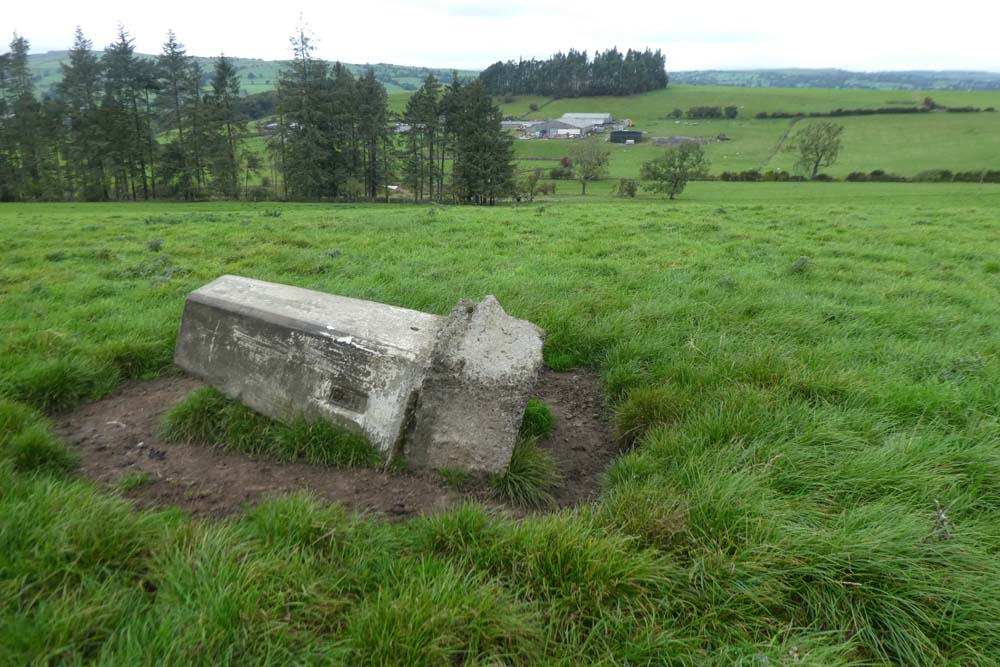
For Dockber I parked in an unpleasant lay-by, apparently part of the old road with access at both ends but sheltered by trees from the busy A59. I reckoned it was just the sort of place you might find a body. The trig was only about two hundred yards from the road but access barred by a substantial hedge. A few perilous hundred yards down the verge as cars whizzed past in excess of 80mph road lead to a public footpath. As I approached, watched with much curiosity by a large herd of sheep, I thought I should be able to see the trig. It was only when I was within ten yards with GPS telling me I was all but on the spot I saw the trig lying unhappily on its side. I wonder why? As I walked back I could see the expanse of the Ribble valley below.
Mason House was reached through a gate on the minor road near Bashall Eaves. I'm not sure if the little field was private but it seemed to be tended as spot to sit on a remembrance bench and muse. The trig was within two feet on the other side of a barbed wire fence but I was able to make human contact. The backdrop was provided by one of BC's oft mentioned hills.
A short drive took me to Spire and my intended linear there and back to Waddington Fell. Spire trig was visible at thirty yards from the car. A few hundred yards further on a curious house named Spire on the map nestles in trees. It has an unusual sort of triple chimney construction. I have done an Internet search but found nothing.
The map shows a path all the way to Waddington Fell but not designated as a public footpath. The going was horrendous. Reeds, tussock grass, bogs, and at one point I took about twenty minutes to get through fifty yards of chest high dead bracken downhill. To start with I was following a walled field boundary but then off into wild moorland with only the occasional faint trace of a trod. The going was heavy. A barbed wire fence was straddled after twisting the barbs back under the plain wire. A wall, part tumbled down was surmounted with difficulty and ingenuity by using my extended walking pole to push the barbed wire away from the wall so I could get down in between. I then realised I had left my other pole behind. I spent another five minutes enticing it at arms length with the wire stretching pole until I could hook its loop and recover. I think if I'd had to get back over that wall I would still be there. This was was one of those days when distance was irrelevant, the overriding factor being the hard going. I watched Sully the other night (landing of the air liner on the Hudson River) and was constantly reminded of the warning issued by the flight simulator saying "terrain,terrain!"
When I arrived at Waddington Fell trig I knew there was no way I was going back the same way.
I had identified a return route to the south involving road walking and footpaths but it was nearly six miles more. I looked good and hard at the map and realised I could return by a shorter route on more amenable tracks and roads to the north, but even that involved a further half hour downhill trek over more pathless moorland before getting onto the easier part.
The final walk out by the road ended with a dispiriting steep ascent to get back to my starting point. I was well tired. According to Memory Map I had covered only 7.74 miles in 6.4 hours with only a stop of about ten minutes for sandwich and coffee. 'Twas an average speed of 1.16 mph, but with ascent of 1358feet. As I said it's the going that matters, not the distance.
 |
| Dockber. I think he'd been on a bender the night before. |
 |
| Looking down the Ribble valley with extensive moorland hills skirting beyond |
 |
| On the way to Mason House. For my fellow blogger* and nature photographer extraordinaire "eat your heart out." |
 |
| Manson House trig situated on the edge of this pleasantly cultivated arbour. |
 |
| For Bowland Climber - see the arrow. The End is nigh! |
 |
| Spire trig from the car, and the reverse below |
 |
| This and Waddington Fell had these Red Rose emblems adorning. Who? Why? |
 |
| Attempts to remove the mounting bracket. They are more secure in that cast concrete than one would think. Ordnance Survey did it right |
 |
| The strangely chimneyed Spire House, and below |
 |
| My route soon left this track and skirted round the left end of the trees with much hard going |
 |
| That is not a path to the right, just a water course |
 |
| Walking pole extended and deployed to increase gap between wall and wire |
 |
| Waddington Fell |
 |
| Miles of wild moorland in every direction |
 |
| Ten out of ten for this versus the convoluted and intricate metal constructions that abound and don't work |
 |
| The final stretch - hard to bear after a tough day |
*Beating the Bounds - have a look:
Click to see his blog.


“Much ado about nothing” Willie would have taken this as a typical Bowland Day.
ReplyDeleteKemple is the End.
There was an easier way back to your car via Crag Stones {see map} but it is all wild moorland.
Congratulations on a good day out.
Mick and I went up Waddington Fell back in 2014. It was an easy ascent from the parking area at the cattle grid to the NE, and I suspect that in hindsight you wish you'd separated Spire and Waddington into two walks, so as to go that way. On the other hand, our short walk was entirely unmemorable (I remember the trig, nearby quarry and mast, but not the walk to get there), whereas you'll not soon forget your approach route.
ReplyDeleteIn a different note: "an unpleasant lay-by, apparently part of the old road with access at both ends but sheltered by trees from the busy A59. I reckoned it was just the sort of place you might find a body."
That sounds like just the sort of place Mick and I would choose to spend the night!
BC - Methinks more like Taming of the Shrew.
ReplyDeleteI see Crag Stones on the map but no indication of a way, and that route would be possibly blocked by several fence/wall boundary lines shown on the map-local knowledge essential. I had intended to take a slightly shorter route on the path going due north from Stone Fold and changed my mind halfway up the track to Stone Fold thinking that the path may present some kind of problem in contrast with the guaranteed safety of the continuing track and road walk. In retrospect I think I was wrong.
-------------------
Gayle - I was aware of the car park you mention but the walk across some previously unvisited wild country appealed to my masochistic instincts. This campaign is not exclusively designed for ticking off the list, it is also the framework to provide for a number of focussed walks within my comfortable distance of eight or nine miles.
I could just imagine me rolling up to that squalid lay-by at 8:30 am to find you two and Bertie parked there. That would be no less remarkable than similar coincidences we have contrived.
Congratulations Conrad, a tough one that, but four more ticked off!
ReplyDeletePaul H. - Now down to 17 remaining. Thanks for the comment.
ReplyDeleteFurther to your route to Waddington Fell, I think the dotted line on the 1:25000 map, 'your path' is a parish boundary. Nevertheless, the whole route is included in open access orange land. This makes a nonsense of open access if you are having to climb walls and straddle barbed wire.
ReplyDeletePS. “Browsholme Spire. It is said that the castellated folly was built as a landmark for shooters on the nearby rough fells.” from https://bowlandclimber.com/2020/11/11/radholme-and-browsholme/
ReplyDeleteBC - Thanks for the enlightenment. I have replied with a new post enabling me to illustrate from the OS legend.
ReplyDeleteRe the Spire, there can't be many places I have been that you haven't.
What gave the idea I hadn't been to the spire — sent you a link. https://bowlandclimber.com/2020/11/11/radholme-and-browsholme/
ReplyDeleteI developed a walk around Bowland several years ago which came that way to Waddington Fell so spent several days searching unsuccessfully for 'paths' in the area.
I've just seen your update post. We have all made the same mistake.
BC - Sorry if I didn't make it clear. It was because you HAD been to the Spire that I couldn't say I had been somewhere you hadn't. I read your link with interest.
ReplyDelete