For newcomers

At the bottom of each post there is the word "comments". If you click on it you will see comments made by followers, and if you follow the instructions you may also comment and I always welcome that. I have found many people overlook this part of the blog which is often more interesting than the original post!

My blog nick-name is SIR HUGH. I'm not from the aristocracy - my middle name is Hugh which relates to the list of 282 hills in Scotland compiled by Sir Hugh Munro in 1891. I climbed my last one (Sgurr Mor) on 28th June 2009

****************************

Monday, 21 July 2025

Tom Jones

Monday 21st July 2025

I have just read (for the second time), Henry Fielding's Tom Jones for my reading group.

In myWordsworth Classics edition  there is a fifteen page introduction written byDoreen Roberts, Rutherford College. University of Kent at Canterbury.

Here is a typical example of some of the worst writing which appears in similar vein throughout the whole piece. I am tempted to use the word "unintelligible" but that means impossible to understand, and to be reluctantly charitable it may be possible to make some sense of this academic self indulgence but not by me. 

Even at the basic level of writing clear English, this extract is inexcusably all one sentence.


Saturday, 19 July 2025

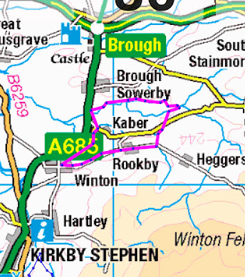
Winton, north of Kirkby Stephen

 Friday 18th July 2025

With my breathlessness affliction walking is now reduced to around five miles. I always take a sandwich and a flask of coffee which usually involves a stop for twenty minutes or so, and including that in the calculation my average speed is coming out at around 1 mph. I''m not bothered about that because at eighty-five I am thankful that even with my problem I am walking further than the majority of folk at this age, and speed is not relevant to enjoyment of the outdoors, rather the slower one goes the more one haas the opportunity to take in the surroundings.

Having said all that I have now, dare I say "inflicted"  on myself, a new means of slowing my pace even more:

The Merlin Bird Recognition App on my iPhone.

With one press of the button you set this device to record birdsong from the surrounding area. Other features provide more detail and means of keeping a record of particular birds identified.  So now I often  find myself stopping on my walks to do a recording. Whilst I believe the app is  sensitive and good at its job I am finding that surprisingly few birds are recorded even in deep countryside where one would expect more. I'm not sure if this is down to a decline in bird populations, or do birds sing more at certain times of day? The rarest recording so far was on my recent walk from Garsdale Station when a Reed Bunting was recorded (but not seen.)

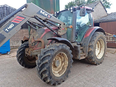
This five mile circuit from Winton involved an initial three kms. of road walking and then varied fields and lanes.You will see a tractor photo below and I chatted the the farmer. I couldn't identify the  make because this monster was so covered in  mud and muck but I was told it was a Valtra, and when I asked permission for the photo he apologised saying he would have washed it if he'd known it was going to be photographed. My later research found that it comes from Finland. Perhaps Alan R will enlighten us a little more?

Towards the end of the walk footpaths avoided the A685 but only after a couple of hundred yards from the road a gate lead into a field. There at thirty yards stood a large white bull with a harem of lady cows just behind. Normally I walk through cow herds without much problem, but here I didn't feel like taking the risk. I backed off and had nearly a mile of dodging traffic on the busy A685 to get back to the finish at Winton.

Leaving Winton. My car is under the big tree

On the way out of Winton

3km. of road walking from Winton but quiet and peaceful


The road obscured the view to the Eden Valley and the hills beyond but a few yards beyond this gate that view opened out, see next photo.
A good bit of recycling here with the tyre


Possibly Mell Fell and Murton Pike


Valtra tractor. Made in Finland.

Leaving the 3km. of road walking

This path was a thistlefest

The public footpath went through this gate, no evidence of recent use

Path went across here, but no path evident on the ground

A feeble trickle was filling the plastic box

"Are you looking st me?"


Belah Bridge. Now bypassed by a modern version on the A685


Start/finish at Winton, anti-clockwise.
The red dots show my diversion down the A685 to avoid bull in field


Thursday, 10 July 2025

North from Garsdale Station

Wednesday 9th July 2025 

For a long time mow I have suffered from far too frequent typos. Unfortunetly I am only a two finger typist which doesn't help. I have just switched off all typing correction except "Check spelling while typing."

This walk was again in Garsdale and adjacent to the Thwaites Bridge walk on my last post. I parked on the road that leads up to Garsdale Station.

Straying from my normal format I will just add captions to the photos and add some other text at the end.


Looking back to the main road from  the station. road 

This was just outside the passenger door of my car.

Strange name. Search for "Mudlocks" revealed a brand of gaiters and a children's play facility

After a couple of hundred yards I left the road for reed and tussocky sheep pasture

Not much of a path but fairly easy going. I met a farmer checking her sheep. She told me I was on the wrong path. I took notice and ended up with a bit of wandering which can be seen on the map below

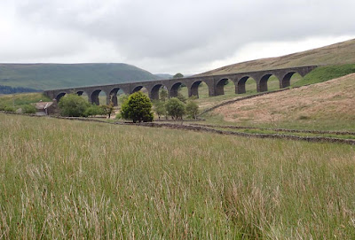
Garsdale railway viaduct. The railway exerts a strong presence in upper Garsdale

Looking back sat Garsdale station


The sun came out suddenly and highlighted these newly shorn sheep

My route went to the railway houses then climbed the fell to the left. I had difficulty finding the path for a while. I have indicated those wanderings on the map below It was all fairly hard going

Having topped out I was now descending on Wainwright's Pennine Journey LDP as far as East House. From there I followed old tracks from one isolated and deserted farm to another.

"Fea Fow" - my photo
17 Nov 2024 — This image was taken from the Geograph project collection. See this photograph's page on the Geograph website for the photographer's contact ...

I think it is now a holiday home. Nobody there today. The public footpath skirted round but I nipped in  through the gate feeling just a little guilty and used the picnic bench for its allocated purpose

"Flust"  - see OS map. Search reveals many different references too numerous to list here but none that would relate to the naming of a remote farmhouse. 

Flust appears to be a used facility for the farmer but I don't think as a residence. It all smacks of bygone farming and a hard life. 

Descent from Flust and my walkout by Grisedale Beck

"Reachey" this and the next. A superbly converted farm residence well in sympathy with the locality
.
Grisedale Back at the approach to Reachey


Grisedale Beck just before it crosses the road to become Clough River flowing off down Garsdale


A lot of this walk had been hard going especially involving 904 feet of ascent. On arrival back at the car I was satisfied and had enjoyed, but felt quite tired.

Have you had that feeling when driving home after a hard cay that time seems to be expanding and that the anticipated hot bath and the like are becoming evermore distant? After leaving the M6 at Jct. 36 the road had just been surfaced with that cop-out method of just chucking down loose gravel. It was like driving through a thick fog and one was conscious of the car being covered in a layer of nasty dust which would need cleaning at the soonest opportunity. At Crooklands the road to Milnthorpe was closed. I had to turn round and go back AGAIN through the dust cloud to Jct. 36 and a three mile detour to get back to Milnthorpe. Unavoidable shopping had me stop at Booth;s supermarket, and then at the garden centre to restock with seed for the starving birds  - was I ever going to get home?

Well I did and because of the tiredness and obstructions on the journey the hot bath was even more appreciated.


Saturday, 5 July 2025

The High Way

 Friday 4th July 2025

This walk starts from Thwaite Bridge, about three kilometers east on the A 684 from The Moorcock Inn. Just beyond Thwaite Bridge there is a large lay-by for parking.

The nine mile drive from Sedbergh down Garsdale to the Moorcock Inn must be one of the  longest  most twisty roads in Britain. Fortunately it is not single track, but still worryingly narrow. The scenery is dramatic in this steep sided archetypal Dales valley and despite the drama of the road it is always an enjoyable experience enhanced by the knowledge that it is the gateway to the still largely unspoilt Yorkshire Dales.

From the lay-by a fifty yard walk back up the A 684 gives access to the old Thwaite Bridge to cross the River Ure. Straight ahead is a not very obvious path leaving the tarmac into a dark and steep brief ascent through woods. The path then opens out onto upland sheep pasture with tussocks and reeds and, for me relatively, a steep huffing and puffing frequent rests ascent gains what is named as The High Way on the 1:25 OS map. This high level ancient bridleway starts from further east on the A684 from my own start and continues to eventually join the Kirkby Stephen Road with Wild Boar Fell looming up on the other side of that road. This track is included in various long distance walks including Lady Anne's Way. I have previously walked on the section opposite Wild Boar Fell past the Water Cut sculpture.

The views from this track are stunning with a complex of steep sided dales and wild hills in all directions, most of which I have memories of visiting over the years, but others that have been missed and are firing the imagination for exploration.

Most of the way there is a broad grassy path following a wall on my left which on and off shelters me a little from the strong wind that persisted throughout the walk.  I keep having to tighten the chin strap on my Tilley hat to stop it turning into an unleashed kite. Every now and then I would peek over the wall and look very steeply down to the river Ure and the A 684 high on the opposite side of the valley. There were a couple of occasions when RAF jets heart stoppingly flew through below my level.

Yet another long distance path, The Pennine Bridleway, branched off to the left to descend to the Moorcock Inn. Where that path crossed the River Ure at Ure Force Rigg there was an attractive mini waterfall and another footpath leading off east to take me back over undulating sheep pastures to Thwaite Bridge. As I was approaching that waterfall I noticed a female walker about fifty yards behind me. I stopped to take a photo and thought she would catch me up, but she also stopped. I guess she thought I may be some kind of predator. It's such a shame that female walkers should feel so threatened. As I went off on my path left she had continued on the path back to the Moorcock.

At Yore House marked on the map I was able to sit on a vehicle trailer for my sandwich and coffee break. This old farm with several buildings was in the process of renovation but had a sort of Marie Celeste atmosphere of dsertion. Tools and equipment had been abandoned looking as though there had been no attempt to tidy before some unexprected urgent departure. Everything about the work being done looked shambolic and disorganised. I'm glad I was not employing the builders involved. I often come across similar rernovations in remote locations all over our countryside where no work is taking place and little evidence of it having been done so recently. Perhaps folk just run out of money, or contractors go bust or walk off after finding the job is more demanding than expected.

I got back to the car at a 3:00 pm. Rain had been forecast for later in the afternoon and it came with a vengeance on the way home, which made me smile a little with some smugness, and I applauded the fairly consistent accuracy of our forecasts these days. It had been a great pleasure to be high up again in the Yorkshire Dales, the best walking area in England in my opinion.


Thwaite Bridge

Sleep ascent from here all the way to The High Way


Out onto the fell side, and below


Looking back up the A684 towards the Moorcock Inn

Back down to Thwaite Bridge before gaining The High Way

Lime kiln in  good condition. One wonders at all the activity that must have been afoot up here at an elevation of 1500ft. or so


Just short of my high point on The High Way

Looking back down to Thwaite Bridge from The High Way. Note the wall I followed up here sheltering me to some extent from the wild wind

Wild Boar Fell

Branching off for my descent on the Pennine Bridleway

Ure Force Rigg

Lunch stop. Yore House, woeful deserted restoration in the background