Saturday 7th May 2022
Walk No. 1 from: The Lune Valley and Howgills, Dennis and Jan Kelsall. Cicerone Press.
A tough little walk for me, eight miles and 1695ft. of ascent, but it was oh so good to get back on some hills again.
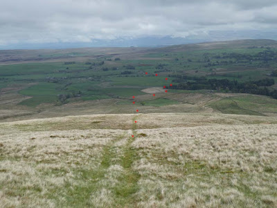
"Twas easy walking as far as Weasedale but then out onto the uncultivated grassy upland and a relentless five kilometre climb much of it on steep ground. I say relentless but from the spot height at 586m, just as one thinks Randygill Top is only now a short distance away one drops very steeply about 100m. to Leathgill Bridge (actually a natural land feature) followed by its corresponding climb out on the other side to gain Randygill summit. If I had looked carefully at the map contours I would have been prepared for this sting in the tail.
From that spot height I thought I could see figures on Randygill summit and I took a zoom shot. When I arrived there was a small orange tent, a radio aerial and a guy with a large, even for its breed, Alsatian dog. The dog saw me and started to bark with savagery but happily for me the guy had hold. However that dog was obviously very strong and its owner was struggling to retain it and I could see a possibility of him loosing control. If that had happened I believe seriously that I would now be dead. I couldn't go to the summit cairn snd turned to pick up the track to Green Bell taking a quick zoom shot back to the summit, the dog, and its owner.
Further down the path a runner came up behind. I had noticed little blue flags marking the path. I was informed that I was on the route used by the SAS as a selection tool for applicants to weed out wanna-bees that would not be up to the mark.
I gleaned more from the marshal on Green Bell. The course is a strenuous fifteen mile trek over these Howgills with a full Bergen rucksack. The guy on Randygill was marshalling a checkpoint. TToday was the annual event open to all, some training to do the selection course for real, and any members of the public who want to have a go either running or walking unencumbered with the rucksack. Today there were fifty entries and they kept passing me from time to time until I veered from their route well down the other side of Green Bell.
A bonus for the walk described in the book was a short diversion to view the source of the River Lune. I have previously been disappointed on similar searches finding nothing much to pinpoint the exact location amongst a mush of peaty ground, but this one didn't disappoint with its well defined spring and a half decent trickle of water and a well defined streamlet leading off to turn west alongside the A 685 and now named River Lune.The first section is named on the map as Dale Gill and this leads into Greenside Beck, but it is quite obvious the these two form the proper origination for the River Lune. I gained a sort of smug satisfaction from this little visit.
That was a good round and would provide an excellent introduction for anybody to the Howgills
 |
| Randygill in the clouds on the right and the summit well back. Green Bell to the left. The clouds cleared and I had good sunny weather for most of the walk |
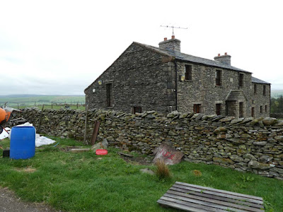 |
| Yet another old farmhouse in the process of renovation. Why do they make such a mess or is it me that is just OCPD? |
 |
| On the way to Randygill |
 |
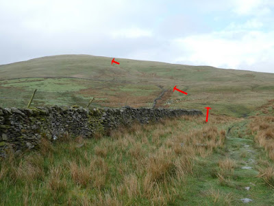
| Red dots - looking back to my route all the way to the A685 |
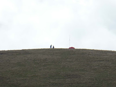 |
| Zoom to strangers on Randygill summit |
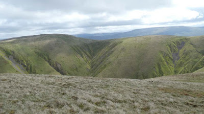 |
| Just a taste of Howgills scenery |
 |
| The loss of height and the required climb out from Leathgill Bridge. It was MUCH steeper on descent and ascent than the photo indicates. |
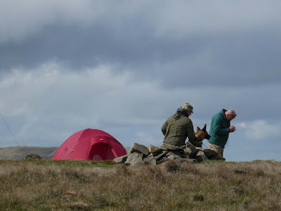 |
| The savage Alsatian on Randygill summit. This was a zoom back I took after putting some distance between me and them |
 |
| On the way to Green Bell |
 |
| A more friendly marshal on Green Bell who told me all bout the SAS selection course and today's event |
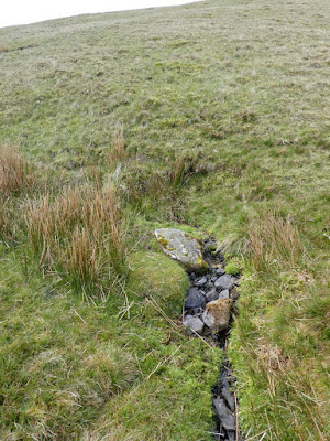 |
| Source of the River Lune and... |
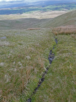 |
| ...off it goes to join the Lune gaining its proper name as it swings west to follow the A685. One would expect this river to flow out north to the Solway but after travelling west to Tebay it swings sharp left and goes south to eventually reach the sea beyond Lancaster. |
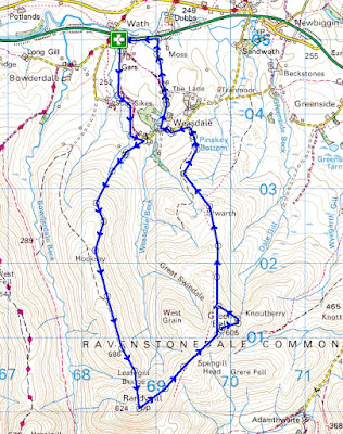 |
| Anti-clockwise from Wath on the A685 |


Been waiting for your next Howgill trip - a good one. Makes me realise I’ve not been in that part of the country for 40 years.
ReplyDeleteWas the Alsatian part of the SAS selection procedure? Put it down as a failure and try again next year.
Not sure about the Alsatian. but would that we could let it loose in the Kremlin.
DeletePity your lovely walk was marred by an aggressive dog Conrad. You seem to have more than your fair share of unpleasant encounters with them.
ReplyDeleteWell done Conrad. You survived yet again! I'd be tempted to get that book, but 'Walking in Lancashire' calls first, as well as being nearer to South Manchester!
ReplyDeleteafoot and phreerunner - I have been a dog enthusiast all my life. We had a Springer spaniel who came with me to Arnside and he sadly went at age 16. I then spent several years looking after my daughter's Springer. I reckon I can read dogs pretty well and even when they come towards me barking I can usually handle them but there are exceptions and I have learnt to be more wary recently. I was genuinely scared by this dog and Alsatians are notoriously unpredictable.
ReplyDelete