For newcomers

At the bottom of each post there is the word "comments". If you click on it you will see comments made by followers, and if you follow the instructions you may also comment and I always welcome that. I have found many people overlook this part of the blog which is often more interesting than the original post!

My blog nick-name is SIR HUGH. I'm not from the aristocracy - my middle name is Hugh which relates to the list of 282 hills in Scotland compiled by Sir Hugh Munro in 1891. I climbed my last one (Sgurr Mor) on 28th June 2009

****************************

Saturday, 30 January 2010

57 - Competition

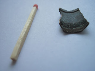
This post poses two puzzles for my followers – there are no prizes for identifying the two items, but I may get less sleepless nights worrying about what they are if somebody out there can provide answers.

I was given a metal detector as a birthday present back in December and have only just got round to using it. The first trial was on the  pebbly beach near home with my daughter Jill. We found a small piece of metal which I am nearly sure is copper or brass. It is curved and on its inner surface has what appears to be a very fine thread. The piece itself appears to be a fragment of something larger.


The next item was found a couple of years ago, and those in the know will instantly recognise the top of a trigpoint. But what is the strange object attached to a sealed  sort of karabiner fixed to a metal bar embedded in the concrete of the trig? It may not be too evident in the pic but there are some sharp spikes sticking upwards on the end of the bottom arm.
The location of the trig was near Calf Holes above Horton in Ribblesdale GR – SD 804 778.

I look forward to some answers!

Wednesday, 27 January 2010

56 - To trust the map or not?

On Mick and Gayle’s last post http://www.gayleybird.blogspot.com/ they discovered a footpath had changed on the map – they were using an older map and found the change updated on a newer version when they got home.

With route and location finding I have found  the map is usually correct. On my last trig points outing (see my Post 55) this was not true. I had difficulty finding the trig at Kelleth NY 664 067 because it was  against a high drystone wall and only visible from the side of the wall we were not on. I was trying to position myself in relation to a mature, deciduous wood that must have been there for over fifty years and measuring perhaps 200m x 200m. This wood turned out to be south-east of the trig and is not shown on the 1:50000 or on the 1:25000 maps although woods to the north of similar size are.


If I can’t make things fit, especially if hot and bothered, or if I’m being blown off my feet by the wind I try to find somewhere to sit down and think it all out carefully. It is so easy to convince yourself that you have made things fit when you haven’t, but if the map is wrong you are unfortunately thrown back onto your, hopefully, vast store of experience.

I have been playing with my Memory Map 2800. Following a footpath on the map there is sometimes a discrepancy between the GPS cursor on the map and the footpath on the map, despite the fact that you know for certain you are on the path. I am not sure whether this is down to inaccurate plotting of the path by the OS or to the vagaries of GPS.

Friday, 22 January 2010

55 - More trig points from OS Sheet 91 - Appleby-in-Westmorland

Thursday 21st January 2009

A pleasant outing with Pete - only a few remnants of the recent snow left.

The first trig was Bretherdale Head (NY 582 053) overlooking the pretty valley of Bretherdale which I have seen before but must be worth another visit.

There was no drama so this is mainly a pictorial report.

We finished off with sandwich and chips in The Black Swan at Ravenstonedale - very agreeable. This is a good venue - they serve this kind of food through the afternoon.


1- Bretherdale Head - 338 m - NY 582 053 


East from Bretherdale Head


Pretty Bretherdale - the trig is up the slope to the right


2 - Kelleth - 307 m - NY 664 058
Looking south to northern end of The Howgills


Kelleth


3 - Wether Hill - 385 m - NY 750 041
Looking south to Wild Boar Fell


Mallerstang Edge in background


Zoom to Wild Boar


On the descent

These three trigs now bring the total visited to nine out of forty nine. I have booked five nights on Wild Rose Caravan Site near Appleby from 11th to 15th April and along with Pete I hope to visit the more northerly ones which are a fairly long drive from my home. Very soon after that trip I hope to backpack the previously mentioned Dales High Way.

Sunday, 17 January 2010

54 - iPhone and Vodaphone stupidity

Well, after all the excitement of the iPhone things have now fallen a bit flat.

I have had two long conversations with Vodaphone. The first ended with a lost connection after being over three quarters of an hour on the phone including waiting time, and just at the point where a solution promised to be forthcoming. The problem was lack of signal at my home, and an inability to connect to my Wi-Fi. The second call informed me that there is no 3G signal in my area, and switching the iPhone to 2G made no difference. I have lived here for over 10 years and have always had medium to good strength signal from Vodaphone as has my daughter Jill. I was told we were lucky because Vodaphone’s information said my post code was only rated for outdoor reception, and my good luck was probably because we use Nokia phones, which are reputedly superior for signal reception.

The result is that the iPhone is going back.

Why don’t Vodaphone look at your post code when you order and advise you about signal strength in your area? I know this can be checked on the Internet, but in my case existing experience told me there was no problem, and many other people would not understand or be aware of the need to check this aspect. Many hours and much money must be wasted by Vodaphone through this lack of customer consideration.

Saturday, 16 January 2010

53 - The speed of technology development


Acquisition of the Memory Map 2800 was intended to save me carrying bulky maps on back packing trips. I also wanted to be able to blog on these trips and therefore ordered an iPhone.

The 2800 was only available from MM just before Christmas and at that time it was state of the art technology. On the same day that I received the iPhone, (Wed. 13th Jan.), I received an email from MM informing me that they will shortly launch an “app” for the iPhone enabling one to load OS maps etc. using the iPhone in the same way as the 2800. If one had not bought the 2800 a month ago and also had the intention of getting an iPhone there would be no need for the 2800, but I now have them both, and will have the disadvantage of carrying both with their respective chargers. Gadgets now seem to be out of date even before they come onto the market!

Further posts will follow on the viability of the iPhone for blogging, and in particular I am interested to discover whether photos from the phone can be uploaded onto a blog.

Thursday, 14 January 2010

52 - Adventurer 2800 by Memory Map

I bought my Memory Map Adventurer 2800 well before Christmas. With some difficulty I purchased and downloaded the French IGN maps I will need for my French trip. I wanted to download the whole of the UK 1:50000 Memory Maps that I have on my PC, but I found the memory card was not big enough. I purchased an 8 gb card from Memory Map and was still unable to download. I had several telephone conversations with MM, and at one stage downloaded a manual for the 2800, the existence of which had not been apparent before. Eventually I got a helpful email detailing an alternative method from Simon Jenkins (Technical Support Development & IT Team Leader) at MM and it was then plain sailing.

Another problem has now developed. When I try to view the French IGN maps on the PC they are just appearing in unreadable, pixelated format. On phoning MM again they are closed because of the bad weather. I have sent an email and am awaiting a reply.

In case anybody out there is having similar problems I would be pleased to share any of the information that I have.

                                           __________________________________
I have been looking at Mick and Gayle's blog  http://gayleybird.blogspot.com/ 
I met them when I was doing my LEJOG walk. They are planning to walk from the southeast tip of Kent to Cape Wrath starting in March. There is a link to a very detailed itinerary that they have planned which may be of interest to readers of this blog.

I admire their detailed planning which is in contrast to my slapdash approach of walking each day and starting to think of finding a stopping place somewhere around 3:00 pm.

Sunday, 3 January 2010

51 Future plans

There is still snow around in Arnside. Local walks have been done each day, but many paths are icy and treacherous. I have had a burst washing machine pipe in the garage, and had to call out Green Flag a couple of days ago to get my car started because the battery had frozen up.

I have booked a flight from Liverpool to Carcassone for 25th May (one way via Ryanair) for my intended walk through The Languedoc and The Cevennes. The plan is to walk north on The GR7 until I am satiated or until I reach Lyons and then improvise on my return journey.

A blog reader requested a copy of my Land’s End/John’oGroats walk journal and subsequent emails revealed his intention to walk The Dales High Way which I mistakenly took to mean The Dalesway, but it turns out that these are two different walks, both of which I reckon are of outstanding quality. I am familiar with most of the territory, but the DHW starts in Saltaire initially traversing the locality of my youth and I fancy a bit of nostalgia, so I intend to do this ninety mile walk on a backpacking basis early in May before I go to France.

I am still committed to completing visits to the forty-nine trig points on OS sheet 91 (see blog number42) of which I have so far visited six. I intend to take the caravan to Middleton-in-Teesdale week commencing either 12th or 19th April for a few days with my friend Pete Mansbridge so that we can do the most northerly of these trigs which are a fair distance from home for day visits. In the meantime I will continue to make day excursions to the more southerly ones.