Wednesday 28th April 2021 - two unnamed summits and an unnamed tarn south of Ings
I suppose it is a bit selfish when I am annoyed when the media publish "the 10 quietest secret places for a walk" or something similar. I have my own such gems and on the whole I'm not particularly keen to broadcast them, but this is one I hope I will be sharing with my readers who are, I believe, mainly like minded souls.
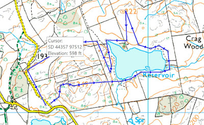
My first ever visit discovered the little hill (spot height 249m on the map below.) The spiky rocky summit is only ten minutes from the minor minor-road but for me it qualifies as a mountain with a character of its own. That narrow, steep road from the A591 at Ings involved opening four gates which is no problem if you have a companion, but drivers more indolent may not think it is worth that effort for such a miniature reward - I think those gates go a long way to preserving the peace of this little area.
The last time I visited was in July 2019 - one of my most pleasurable outings, especially being in the company of granddaughter Katie - the post with the included walk is worth a read supported by jolly photos.
From my first ever visit I had spotted an extensive and pretty tarn down below the other side of my mini mountain. Looking at the map there are no footpaths or public rights of way over an extensive area surrounding the tarn. Neither my hill nor the tarn have names even on the OS 1:25 map, another reason perhaps for their continued tranquility. On another visit I met an angler just setting off to angle in the tarn and we chatted and I realised there must be a way round the shoulder of my hill though the various field boundaries. Today I ascended the peak, dropped down the other side and walked round the tarn, ascended another high point to the north, spot height 222m. and returned by the aforementioned angler's path. That second peak was the third unnamed feature visited and much understated its standing when I had a whole new view of the A591 winding far down below with the backdrop of the Kentmere hills behind.
This less than two mile outing belied its apparent value and long may it continue to do so.
 |
| From the 249m summit with the surprise view of the tarn in a good sized area with, supposedly, no public access |
 |
| Looking back to 249m from the far side of the tarn |
 |
| Number three unnamed is at the peak of the route furthest north |


Nice one JJ. £185 for fishing subs. Does that include chips?
ReplyDeleteApologies "Conrad" i was reading JJ's posting on split screen.
ReplyDeleteBack of beyond.
ReplyDeleteHave you applied for a rod?
Alan R and BC - If I was much younger I would have endeavoured to join. For that kind of environment it would have been worth every penny. By the way, their rule is "catch-and-return only." I used to fly fish in my youth but my attitude to all blood sports, especially grouse and pheasant shooting and hunting with hounds has hardened dramatically over the years and now I would have an uneasy feeling about the fishing, tempered a little by that policy. I think they also use barbless hooks
ReplyDelete--------------------
In the days when rock-climbers all had classical educations they also took advantage of nature's anonymity (as you have done) and christened their ascents accordingly. But they couldn't resist showing they were intellectually superior to the oiks they met across the pub bar subsequently. Hence Innominate this and that, there's more than one I believe. You might wonder if they carried pocket dictionaries for the christening ceremonies but I doubt it. Their reference point would always be the twelve-volume OED, hence the need for Sherpas and thus the need to move out to the Himalayas
ReplyDeleteRR - Others stuck with understatement: Central Buttress, Botterill's Slab, A climb, Great Gully, Main Wall Climb, which give no hint either way of the difficulty. Modern day nomenclature is much more eclectic coming from the full range of social backgrounds - unfortunately I don't think there is a ten volume dictionary of popular music which, if you wanted to interpret, would be helpful, along with a working knowledge of hallucinatory drugs.
ReplyDelete