Sunday 26th June 2022
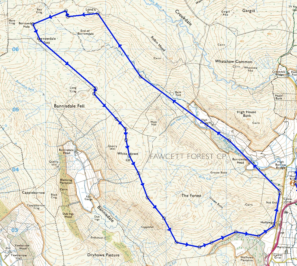
Upper Borrowdale and White Howe - 7.7 miles - 1565 feet of ascent
I believe we all have to-do lists. For me, some get ticked off and others not. This one has been with me for about twenty years soon after I discovered the lower part of this Borrowdale. A few days ago I tackled an unfinished part of that one with the north-west ridge.
I have eyed the map for years for this upper part of Borrowdale to the west of the A6 but have dithered due to absence of footpaths on the map and wall boundaries that are shown potentially hindering the route. My original plot on Memory Map was therefore largely straight lined coming in at 6.95 miles. The route as walked shown below took advantage of paths found extending distance to 7.7 miles.
Some possible rain was forecast but this was my only chance of a decent walk for the next few days. With the car parked conveniently on the verge at the entrance to the private road for High Barrow Farm I had a splendid view of the A6 going north to Shap. The descent coming south from the memorial to the haulage drivers of old at the summit is one of the finest downhill runs on a bike in the country.
The weather was overcast and broody so once again the photos from the new Olympus TG6 were pale, but hopefully because they were portraying the truth of this dreish day.
High Barrow Farm where the tarmac ends is truly isolated and primitive looking. A Land Rover track continues and I was followed by a herd of sheep - I guess they rarely see humans. From a more isolated cottage, unoccupied I was on only rudimentary paths more akin to sheep trods. The feeling of pure wilderness was palpable, and much as I have eulogised about Lower Borrowdale this made that gem seem almost metropolitan, what a discovery! Borrow Beck was not in full force but as we coincided every so often it made a major contribution to this landscape running over its rocky bed with mini waterfalls and deep pools of clear but dark brown water. Further on, the way started to climb and the stream was tumbling steeply down under a rickety old bridge of timber beams which I crossed with some trepidation - rot had set in good and proper.
An area of about twenty metres square had been fenced off marking the point where I started the ascent of High House Fell, the north-eastern marker for the head of Upper Borrowdale. The small enclosure protected one from a gloopy sort of sinkhole with surrounding evil looking bog. If you had the misfortune to get in there I think the chances of getting out would be remote - thanks to whoever had the goodwill to enclose.
A stiff pathless climb took me to the summit and then a trek across the head of the valley where I lost more height than I intended. The rain now started. Waterproof was donned, rucksack cover deployed, compass bearing taken, and then I squelched through reeds and rough marshy terrain to get back on track.
From here on the wind rose to gale force on the tops accompanied by bouts of fairly heavy rain, conditions that hinder route finding and discourage photography. Fortunately stiles were found where I had previously worried about field boundaries. Without being too dramatic I was now in mild survival mode for the rest of the walk. I had bee-lined my route from the trig on the summit of White Howe back to my car, but I found a poor path which lead me round the houses: the main contributor to the route walked being longer than the one plotted. I did keep dry but by the time I got back to the car I was well tired, and not having looked at the time since my ascent to the ridge I was staggered to find I had taken 7.75 hours to walk 7.7 miles (with no stops.) My flask and sandwiches were still in my sack and the latter served as the main part of my evening meal back home.
The lack of decent paths, and the paths found being those only one foot wide troughs interspersed with rocks and tussocks had made for very slow going. The second half of the walk had been hard but that didn't detract from the pleasure of discovery during the walk to the head of Upper Borrowdale and I would recommend that to anybody, but perhaps just as a there-and-back.
 |
| Looking up to the summit of the A6. A fine cycle ride descent |
 |
| Approaching High Barrow Farm - looking up into Upper Borrowdale |
 |
| High Barrow Farm |
 |
| Looking back to High Barrow |
 |
| The sheep followed me in a huge herd until I went through the gate at the white cottage further on |
 |
| After the white cottage just ill-defined footpaths but great scenery and ambiance |
 |
| Note the bridge, and below. |
 |
| Looking back down Upper Borrowdale, and below |
 |
| From the ascent of High House Fell summit. My route crossed terrain to ascend the ridge on the left. The fenced enclosure is centre picture but not easy to see - click to enlarge. |
 |
| White Howe trig. From here self preservation was the priority. not photography |
 |
| My plotted route (not shown) took a straight line from White Howe trig back to the car but a rough footpath lead me on a wandering route as shown but better than a long stretch through rough tussocks, peat, heather, bracken and the rest. |
 |
| In context including Borrowdale proper and my recent route on the north west ridge |


Well done!
ReplyDeleteOlympus camera? What happened to the Lumix? I'm rarely using my TZ90 - not going on holiday often enough!
I thought a few of those ridges looked familiar, and yes we were there back in May 2016 doing the Wainwright Outliers.
ReplyDeletePhreerunner - The TZ 80 stopped operating its zoom. It went back to Panasonic via Wilkinson's Cameras in Kendal. I was told that these long zoom compacts are susceptible to ingesting foreign bodies with the lens popping in ad out. In addition to that I have always been concerned about the camera getting wet in bad weather. Whilst the TZ80 was away I browsed and discovered this Olympus TG6. It is waterproof (it can be used underwater if you want.) It is also built like a steam locomotive and has the designation "tough." The only downside is its limited 4x zoom which operates inside the camera, but still optical. So with my record for camera abuse it sounded like the one for me. I then went through the familiar retail disease of prevarication invoking all kinds of excuses for its acquisition or not. Wilkinsons offered me £90 for the TZ80 when it was returned free of charge under guarantee, so I decided to keep it anyway. There you have it.
ReplyDelete-------------------------------------
BC - Yes, I meant to mention our visit in much better weather I seem to remember. What a grand finale for our Wainwright's Outlying Fells campaign encompassing all the Bannisdale Horseshoe. That was a superb and rewarding project.
Can't believe it was six years ago.
ReplyDeleteGood luck with the Olympus, Conrad.
ReplyDeleteBC - Wow! Six years. It makes one eager to use every moment wisely.
ReplyDelete----------------------------------------
Phreerunner - I'm hoping to give it a better trial today on my walk with Pete although it is still hardly bright and sunny at 8;30 am. We will see.